Pincodes of Almora
Almora Pincodes: Discover the key to precise addressing in the enchanting town of Almora with our comprehensive list of Almora Pincodes. Navigate seamlessly through the picturesque landscapes and historic sites by having the exact postal codes at your fingertips. Whether you’re sending a letter, parcel, or searching for a location, our Almora Pincodes database ensures accuracy. From the bustling markets to serene residential areas, easily locate destinations with our user-friendly interface. Stay connected with the heart of Almora by using Almora Pincodes, your ultimate guide to efficient and reliable postal information for this charming town in Uttarakhand.
Here is a list of Almora Pincodes
| No. | Location | Pincode | District | State |
|---|---|---|---|---|
| 1 | Aina | 263652 | Almora | Uttarakhand |
| 2 | Airari Bisht | 263665 | Almora | Uttarakhand |
| 3 | Ajoli Malli | 263646 | Almora | Uttarakhand |
| 4 | Almiankande | 263645 | Almora | Uttarakhand |
| 5 | Almora | 263601 | Almora | Uttarakhand |
| 6 | Almora College | 263601 | Almora | Uttarakhand |
| 7 | Almora Court | 263601 | Almora | Uttarakhand |
| 8 | Amdhar | 263676 | Almora | Uttarakhand |
| 9 | Amyari | 263645 | Almora | Uttarakhand |
| 10 | Andoli | 263623 | Almora | Uttarakhand |
| 11 | Anuli | 263625 | Almora | Uttarakhand |
| 12 | Asgoli | 263654 | Almora | Uttarakhand |
| 13 | Ayarpani | 263601 | Almora | Uttarakhand |
| 14 | Badiyar | 263622 | Almora | Uttarakhand |
| 15 | Bagswar | 263626 | Almora | Uttarakhand |
| 16 | Bagwalipokhar | 263621 | Almora | Uttarakhand |
| 17 | Bainskhet | 263655 | Almora | Uttarakhand |
| 18 | Bajwar | 263601 | Almora | Uttarakhand |
| 19 | Baldhoti | 263601 | Almora | Uttarakhand |
| 20 | Balta | 263601 | Almora | Uttarakhand |
| 21 | Bamanswal | 263623 | Almora | Uttarakhand |
| 22 | Bamsyun | 263645 | Almora | Uttarakhand |
| 23 | Bangidhar | 263676 | Almora | Uttarakhand |
| 24 | Baninsargaon | 263627 | Almora | Uttarakhand |
| 25 | Banthok | 263623 | Almora | Uttarakhand |
| 26 | Barangal | 263659 | Almora | Uttarakhand |
| 27 | Barechhina | 263624 | Almora | Uttarakhand |
| 28 | Barsimi | 263636 | Almora | Uttarakhand |
| 29 | Basai | 263661 | Almora | Uttarakhand |
| 30 | Basantpur | 263626 | Almora | Uttarakhand |
| 31 | Basbhira | 263653 | Almora | Uttarakhand |
| 32 | Basoli | 263622 | Almora | Uttarakhand |
| 33 | Basot | 263680 | Almora | Uttarakhand |
| 34 | Bawari Kichar | 263665 | Almora | Uttarakhand |
| 35 | Bayeri | 263663 | Almora | Uttarakhand |
| 36 | Bedchula | 263625 | Almora | Uttarakhand |
| 37 | Bergaon | 263678 | Almora | Uttarakhand |
| 38 | Bey | 263601 | Almora | Uttarakhand |
| 39 | Bhabu | 263626 | Almora | Uttarakhand |
| 40 | Bhagoti | 263656 | Almora | Uttarakhand |
| 41 | Bhagtola | 263689 | Almora | Uttarakhand |
| 42 | Bhainsiachhana | 263624 | Almora | Uttarakhand |
| 43 | Bhainsoli | 263652 | Almora | Uttarakhand |
| 44 | Bhainsori | 263684 | Almora | Uttarakhand |
| 45 | Bhairongkhal | 244718 | Almora | Uttarakhand |
| 46 | Bhanoli | 263687 | Almora | Uttarakhand |
| 47 | Bhatkola | 263601 | Almora | Uttarakhand |
| 48 | Bhatkote | 263656 | Almora | Uttarakhand |
| 49 | Bhatronjkhan | 263646 | Almora | Uttarakhand |
| 50 | Bhaunkhal | 263646 | Almora | Uttarakhand |
| 51 | Bheltgaon | 263656 | Almora | Uttarakhand |
| 52 | Bhikiyasen | 263667 | Almora | Uttarakhand |
| 53 | Bhoolgaon | 263627 | Almora | Uttarakhand |
| 54 | Bhujan | 263645 | Almora | Uttarakhand |
| 55 | Bhyari | 263676 | Almora | Uttarakhand |
| 56 | Bilekh | 263663 | Almora | Uttarakhand |
| 57 | Binta | 263621 | Almora | Uttarakhand |
| 58 | Birkham | 263626 | Almora | Uttarakhand |
| 59 | Birkola | 263622 | Almora | Uttarakhand |
| 60 | Birora | 263601 | Almora | Uttarakhand |
| 61 | Bisrakhet | 263661 | Almora | Uttarakhand |
| 62 | Bitholi | 263653 | Almora | Uttarakhand |
| 63 | Chachroti | 263661 | Almora | Uttarakhand |
| 64 | Chagethi | 263623 | Almora | Uttarakhand |
| 65 | Chaikhan | 263625 | Almora | Uttarakhand |
| 66 | Chakargaon | 263659 | Almora | Uttarakhand |
| 67 | Chamarkhan | 263664 | Almora | Uttarakhand |
| 68 | Chamkana | 263676 | Almora | Uttarakhand |
| 69 | Chamtola | 263622 | Almora | Uttarakhand |
| 70 | Chamu Uchyur | 263601 | Almora | Uttarakhand |
| 71 | Chanoda | 263629 | Almora | Uttarakhand |
| 72 | Chantharia | 263653 | Almora | Uttarakhand |
| 73 | Charchalikhan | 263623 | Almora | Uttarakhand |
| 74 | Chaubattia | 263651 | Almora | Uttarakhand |
| 75 | Chaukuni | 263645 | Almora | Uttarakhand |
| 76 | Chaun Dungri | 263622 | Almora | Uttarakhand |
| 77 | Chaunallia | 263680 | Almora | Uttarakhand |
| 78 | Chaunsli | 263601 | Almora | Uttarakhand |
| 79 | Chelchhina | 263623 | Almora | Uttarakhand |
| 80 | Chhana | 263645 | Almora | Uttarakhand |
| 81 | Chhana Kharkota | 263626 | Almora | Uttarakhand |
| 82 | Chhatena | 263653 | Almora | Uttarakhand |
| 83 | Chhatgulla | 263653 | Almora | Uttarakhand |
| 84 | Chhitar | 263656 | Almora | Uttarakhand |
| 85 | Chilianaula | 263645 | Almora | Uttarakhand |
| 86 | Chitai | 263601 | Almora | Uttarakhand |
| 87 | Chitreshwar | 263653 | Almora | Uttarakhand |
| 88 | Dabhra | 263667 | Almora | Uttarakhand |
| 89 | Dal | 263601 | Almora | Uttarakhand |
| 90 | Dania | 263622 | Almora | Uttarakhand |
| 91 | Darmar | 263645 | Almora | Uttarakhand |
| 92 | Darmar Tikhun | 263643 | Almora | Uttarakhand |
| 93 | Dasolibadiyar | 263622 | Almora | Uttarakhand |
| 94 | Daula | 263660 | Almora | Uttarakhand |
| 95 | Dauligarh | 263622 | Almora | Uttarakhand |
| 96 | Daurakhal | 263664 | Almora | Uttarakhand |
| 97 | Debikhal | 263676 | Almora | Uttarakhand |
| 98 | Deghat | 263659 | Almora | Uttarakhand |
| 99 | Deolikhan | 263643 | Almora | Uttarakhand |
| 100 | Deolikhet | 263664 | Almora | Uttarakhand |
| 101 | Dhamas | 263601 | Almora | Uttarakhand |
| 102 | Dhamdewal | 263656 | Almora | Uttarakhand |
| 103 | Dhamera | 263660 | Almora | Uttarakhand |
| 104 | Dharkhola | 263625 | Almora | Uttarakhand |
| 105 | Dhauladevi | 263683 | Almora | Uttarakhand |
| 106 | Dhaulaghat | 263655 | Almora | Uttarakhand |
| 107 | Dhaulara Totashilling | 263629 | Almora | Uttarakhand |
| 108 | Dhaularh | 263627 | Almora | Uttarakhand |
| 109 | Dhaulchhina | 263681 | Almora | Uttarakhand |
| 110 | Dhaunigarh | 263627 | Almora | Uttarakhand |
| 111 | Dhaura | 263601 | Almora | Uttarakhand |
| 112 | Dhura | 263622 | Almora | Uttarakhand |
| 113 | Dhyari | 263622 | Almora | Uttarakhand |
| 114 | Dhyuli | 263625 | Almora | Uttarakhand |
| 115 | Dinapani | 263601 | Almora | Uttarakhand |
| 116 | Doram | 263623 | Almora | Uttarakhand |
| 117 | Dova | 263601 | Almora | Uttarakhand |
| 118 | Dunagiri | 263653 | Almora | Uttarakhand |
| 119 | Dunar | 263623 | Almora | Uttarakhand |
| 120 | Dwarahat | 263653 | Almora | Uttarakhand |
| 121 | Dwarson | 263652 | Almora | Uttarakhand |
| 122 | Gairkhet | 263658 | Almora | Uttarakhand |
| 123 | Ganai | 263656 | Almora | Uttarakhand |
| 124 | Ganiadeoli | 263677 | Almora | Uttarakhand |
| 125 | Garkote Malla | 263676 | Almora | Uttarakhand |
| 126 | Garurabanj | 263623 | Almora | Uttarakhand |
| 127 | Gewapani | 263655 | Almora | Uttarakhand |
| 128 | Gewar | 263653 | Almora | Uttarakhand |
| 129 | Ghatti | 263646 | Almora | Uttarakhand |
| 130 | Ghuguti Kelani | 263659 | Almora | Uttarakhand |
| 131 | Godi | 263656 | Almora | Uttarakhand |
| 132 | Golchhina | 263655 | Almora | Uttarakhand |
| 133 | Gudlekh | 263661 | Almora | Uttarakhand |
| 134 | Gunaditya | 263623 | Almora | Uttarakhand |
| 135 | Gurkande | 263636 | Almora | Uttarakhand |
| 136 | Haldiyani | 263645 | Almora | Uttarakhand |
| 137 | Harara | 263646 | Almora | Uttarakhand |
| 138 | Hawalbagh | 263636 | Almora | Uttarakhand |
| 139 | I.T.i. almora | 263601 | Almora | Uttarakhand |
| 140 | Irah | 263653 | Almora | Uttarakhand |
| 141 | Jageshwar | 263623 | Almora | Uttarakhand |
| 142 | Jaikhal | 263659 | Almora | Uttarakhand |
| 143 | Jainti | 263626 | Almora | Uttarakhand |
| 144 | Jairambakhal | 263656 | Almora | Uttarakhand |
| 145 | Jakh | 263646 | Almora | Uttarakhand |
| 146 | Jalali | 263662 | Almora | Uttarakhand |
| 147 | Jalna | 263625 | Almora | Uttarakhand |
| 148 | Jamoli | 263667 | Almora | Uttarakhand |
| 149 | Jamrari | 263624 | Almora | Uttarakhand |
| 150 | Jaurasi | 263656 | Almora | Uttarakhand |
| 151 | Jayanteshwar Simalchaura | 263661 | Almora | Uttarakhand |
| 152 | Jeoli | 263643 | Almora | Uttarakhand |
| 153 | Jhaldungra | 263626 | Almora | Uttarakhand |
| 154 | Jhankarsaim | 263623 | Almora | Uttarakhand |
| 155 | Jharkote | 263658 | Almora | Uttarakhand |
| 156 | Jhimar | 263676 | Almora | Uttarakhand |
| 157 | Jhupulchaura | 263627 | Almora | Uttarakhand |
| 158 | Jingoli Toli | 263622 | Almora | Uttarakhand |
| 159 | Kafalata Malla | 263676 | Almora | Uttarakhand |
| 160 | Kafalisuwakhan | 263623 | Almora | Uttarakhand |
| 161 | Kafalni | 263622 | Almora | Uttarakhand |
| 162 | Kafara | 263675 | Almora | Uttarakhand |
| 163 | Kafarkhan | 263601 | Almora | Uttarakhand |
| 164 | Kalika Estate | 263645 | Almora | Uttarakhand |
| 165 | Kanarichhina | 263624 | Almora | Uttarakhand |
| 166 | Kanoli | 263664 | Almora | Uttarakhand |
| 167 | Kantali | 263639 | Almora | Uttarakhand |
| 168 | Kasermanya | 263623 | Almora | Uttarakhand |
| 169 | Kathpuria | 263643 | Almora | Uttarakhand |
| 170 | Kausani | 263639 | Almora | Uttarakhand |
| 171 | Kausani Estate | 263620 | Almora | Uttarakhand |
| 172 | Kayala | 263643 | Almora | Uttarakhand |
| 173 | Kelani | 263661 | Almora | Uttarakhand |
| 174 | Khadalgaon | 263661 | Almora | Uttarakhand |
| 175 | Khalna | 263653 | Almora | Uttarakhand |
| 176 | Kharaun | 263601 | Almora | Uttarakhand |
| 177 | Khastilari | 263624 | Almora | Uttarakhand |
| 178 | Khatiyola | 263622 | Almora | Uttarakhand |
| 179 | Khatyari | 263656 | Almora | Uttarakhand |
| 180 | Kheti | 263622 | Almora | Uttarakhand |
| 181 | Khira | 263656 | Almora | Uttarakhand |
| 182 | Khirkhet | 263645 | Almora | Uttarakhand |
| 183 | Khola | 263623 | Almora | Uttarakhand |
| 184 | Khumar | 263676 | Almora | Uttarakhand |
| 185 | Kirara | 263601 | Almora | Uttarakhand |
| 186 | Kosi | 263643 | Almora | Uttarakhand |
| 187 | Kotagiwai | 263680 | Almora | Uttarakhand |
| 188 | Kotar | 263663 | Almora | Uttarakhand |
| 189 | Kotuli Malli | 263646 | Almora | Uttarakhand |
| 190 | Kulanteshwar | 263661 | Almora | Uttarakhand |
| 191 | Kulsibi | 263652 | Almora | Uttarakhand |
| 192 | Kunhil | 263667 | Almora | Uttarakhand |
| 193 | Kuwali | 263652 | Almora | Uttarakhand |
| 194 | Lakhani | 263639 | Almora | Uttarakhand |
| 195 | Lala Bazar | 263601 | Almora | Uttarakhand |
| 196 | Lambagara | 263625 | Almora | Uttarakhand |
| 197 | Laubanj | 263639 | Almora | Uttarakhand |
| 198 | Laxmeshwar | 263601 | Almora | Uttarakhand |
| 199 | Lod | 263627 | Almora | Uttarakhand |
| 200 | Lodhia | 263601 | Almora | Uttarakhand |
| 201 | Lweshal | 263629 | Almora | Uttarakhand |
| 202 | Machhor | 263646 | Almora | Uttarakhand |
| 203 | Mahakaleshwar | 263653 | Almora | Uttarakhand |
| 204 | Maharagaon | 263623 | Almora | Uttarakhand |
| 205 | Maithani | 263676 | Almora | Uttarakhand |
| 206 | Majkhali | 263652 | Almora | Uttarakhand |
| 207 | Manan | 263638 | Almora | Uttarakhand |
| 208 | Manela | 263645 | Almora | Uttarakhand |
| 209 | Mangalta | 263624 | Almora | Uttarakhand |
| 210 | Mangdoli | 263645 | Almora | Uttarakhand |
| 211 | Manhet | 263676 | Almora | Uttarakhand |
| 212 | Maniagar | 263624 | Almora | Uttarakhand |
| 213 | Manila | 263667 | Almora | Uttarakhand |
| 214 | Manuli | 263667 | Almora | Uttarakhand |
| 215 | Marku Bakhal | 263656 | Almora | Uttarakhand |
| 216 | Masar | 263645 | Almora | Uttarakhand |
| 217 | Masi | 263658 | Almora | Uttarakhand |
| 218 | Matela | 263665 | Almora | Uttarakhand |
| 219 | Mathena | 263625 | Almora | Uttarakhand |
| 220 | Maulekhal | 263676 | Almora | Uttarakhand |
| 221 | Mayoli | 263622 | Almora | Uttarakhand |
| 222 | Mirai Malli | 263645 | Almora | Uttarakhand |
| 223 | Mirtola | 263623 | Almora | Uttarakhand |
| 224 | Motiapathar | 263625 | Almora | Uttarakhand |
| 225 | Munani | 263659 | Almora | Uttarakhand |
| 226 | Nagarjhan | 263653 | Almora | Uttarakhand |
| 227 | Nagarkhan | 263624 | Almora | Uttarakhand |
| 228 | Naikana | 263658 | Almora | Uttarakhand |
| 229 | Nail | 263625 | Almora | Uttarakhand |
| 230 | Nail Chaukote | 263665 | Almora | Uttarakhand |
| 231 | Naila | 263660 | Almora | Uttarakhand |
| 232 | Naini | 263623 | Almora | Uttarakhand |
| 233 | Nali | 263623 | Almora | Uttarakhand |
| 234 | Naraindewal | 263624 | Almora | Uttarakhand |
| 235 | Naubara | 263660 | Almora | Uttarakhand |
| 236 | Naughar Estate | 263639 | Almora | Uttarakhand |
| 237 | Naula | 263658 | Almora | Uttarakhand |
| 238 | Naulakote | 263621 | Almora | Uttarakhand |
| 239 | Naura | 263625 | Almora | Uttarakhand |
| 240 | Neoliharara | 263623 | Almora | Uttarakhand |
| 241 | Painsia | 263676 | Almora | Uttarakhand |
| 242 | Paithani | 263653 | Almora | Uttarakhand |
| 243 | Pali | 263680 | Almora | Uttarakhand |
| 244 | Palyun | 263624 | Almora | Uttarakhand |
| 245 | Pandekota | 263645 | Almora | Uttarakhand |
| 246 | Panduwakhal | 263656 | Almora | Uttarakhand |
| 247 | Pantgaon | 263680 | Almora | Uttarakhand |
| 248 | Pantkotuli | 263645 | Almora | Uttarakhand |
| 249 | Panuwadeokhan | 263646 | Almora | Uttarakhand |
| 250 | Panuwanaula | 263623 | Almora | Uttarakhand |
| 251 | Patalibangar | 263636 | Almora | Uttarakhand |
| 252 | Patharkhola | 263661 | Almora | Uttarakhand |
| 253 | Patia | 263601 | Almora | Uttarakhand |
| 254 | Petshal | 263601 | Almora | Uttarakhand |
| 255 | Pilkha | 263601 | Almora | Uttarakhand |
| 256 | Pilkholi | 263671 | Almora | Uttarakhand |
| 257 | Pipalkhal | 263661 | Almora | Uttarakhand |
| 258 | Pipna | 263676 | Almora | Uttarakhand |
| 259 | Pitoli | 263622 | Almora | Uttarakhand |
| 260 | Pokhari | 263638 | Almora | Uttarakhand |
| 261 | Pokharkhali | 263601 | Almora | Uttarakhand |
| 262 | Pubhaon | 263626 | Almora | Uttarakhand |
| 263 | Querala | 263667 | Almora | Uttarakhand |
| 264 | Rajyura | 263626 | Almora | Uttarakhand |
| 265 | Ramara | 263655 | Almora | Uttarakhand |
| 266 | Rampur | 263656 | Almora | Uttarakhand |
| 267 | Ranban | 263638 | Almora | Uttarakhand |
| 268 | Ranikhet | 263645 | Almora | Uttarakhand |
| 269 | Ranikhet Kutchery | 263645 | Almora | Uttarakhand |
| 270 | Ranikhet Sadar bazar | 263645 | Almora | Uttarakhand |
| 271 | Rasyaragaon | 263627 | Almora | Uttarakhand |
| 272 | Ratgal | 263652 | Almora | Uttarakhand |
| 273 | Rikhe | 263655 | Almora | Uttarakhand |
| 274 | Rokhon | 263659 | Almora | Uttarakhand |
| 275 | Rotapani | 263658 | Almora | Uttarakhand |
| 276 | Rudoli | 263661 | Almora | Uttarakhand |
| 277 | Sagneti | 263664 | Almora | Uttarakhand |
| 278 | Sainj | 263624 | Almora | Uttarakhand |
| 279 | Sainmanpur | 263667 | Almora | Uttarakhand |
| 280 | Saknara | 263667 | Almora | Uttarakhand |
| 281 | Salla Bhatkote | 263624 | Almora | Uttarakhand |
| 282 | Salparh | 263622 | Almora | Uttarakhand |
| 283 | Sanara | 263658 | Almora | Uttarakhand |
| 284 | Sarikhet | 263661 | Almora | Uttarakhand |
| 285 | Satyun | 263625 | Almora | Uttarakhand |
| 286 | Sauni | 263663 | Almora | Uttarakhand |
| 287 | Seem | 263680 | Almora | Uttarakhand |
| 288 | Shaharphatak | 263625 | Almora | Uttarakhand |
| 289 | Shishuwa | 263663 | Almora | Uttarakhand |
| 290 | Shitalakhet | 263678 | Almora | Uttarakhand |
| 291 | Silor Mahadev | 263645 | Almora | Uttarakhand |
| 292 | Sinar | 263667 | Almora | Uttarakhand |
| 293 | Sinora | 263645 | Almora | Uttarakhand |
| 294 | Someshwar | 263627 | Almora | Uttarakhand |
| 295 | Sona Shilling | 263622 | Almora | Uttarakhand |
| 296 | Sunoli | 263601 | Almora | Uttarakhand |
| 297 | Sure | 263653 | Almora | Uttarakhand |
| 298 | Suri | 263678 | Almora | Uttarakhand |
| 299 | Syalde | 263661 | Almora | Uttarakhand |
| 300 | Syalidhar | 263601 | Almora | Uttarakhand |
| 301 | Syunai | 263625 | Almora | Uttarakhand |
| 302 | Takula | 263628 | Almora | Uttarakhand |
| 303 | Tamadhaun | 263661 | Almora | Uttarakhand |
| 304 | Tapani | 263622 | Almora | Uttarakhand |
| 305 | Taragtal | 263656 | Almora | Uttarakhand |
| 306 | Tarikhet | 263663 | Almora | Uttarakhand |
| 307 | Taya | 263680 | Almora | Uttarakhand |
| 308 | Thali | 263622 | Almora | Uttarakhand |
| 309 | Thana Bazar | 263601 | Almora | Uttarakhand |
| 310 | Thapania | 263636 | Almora | Uttarakhand |
| 311 | Thikalna | 263623 | Almora | Uttarakhand |
| 312 | Timilkhal | 263658 | Almora | Uttarakhand |
| 313 | Timtha | 263660 | Almora | Uttarakhand |
| 314 | Tolyun | 263646 | Almora | Uttarakhand |
| 315 | Totam | 263646 | Almora | Uttarakhand |
| 316 | Turachaura | 263658 | Almora | Uttarakhand |
| 317 | Udepur | 263661 | Almora | Uttarakhand |
| 318 | Ugalia | 263680 | Almora | Uttarakhand |
| 319 | Ujrar | 263667 | Almora | Uttarakhand |
| 320 | Uprari | 263686 | Almora | Uttarakhand |
| 321 | Uprari Chaukote | 263659 | Almora | Uttarakhand |
| 322 | Zoor | 263601 | Almora | Uttarakhand |
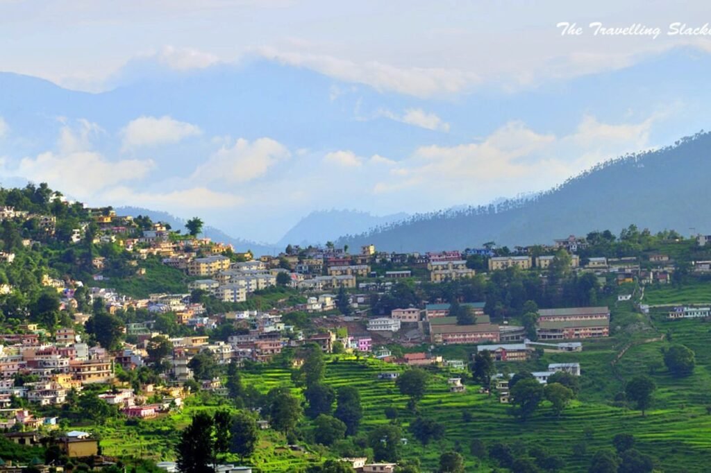
About Almora
Almora, aka Almāḍ in Kumaoni, is a town in Uttarakhand, India, serving as a municipal board and cantonment. Serving as the administrative hub of Almora district, it perches atop a ridge at the southern fringes of the Kumaon Hills in the Himalayas. Flanked by the Koshi (Kaushiki) and Suyal (Salmale) rivers, this scenic town offers a backdrop of the majestic snow-capped Himalayas. Established in 1568 by King Kalyan Chand, its roots trace back to ancient times, mentioned even in the Mahabharata. Almora, once the seat of Chand kings ruling the Kumaon Kingdom, remains the vibrant cultural nucleus of Uttarakhand’s Kumaon region.