Banswara Pincodes
Enter the Pincode or Location Below in the Box
Pincodes of Banswara
Banswara Pincodes: Discover the Precise Postal Codes of Banswara, RajasthanWelcome to ‘Pincodes of My Location,’ your go-to destination for accurate postal information in India. Explore Banswara’s diverse landscape with ease by accessing a comprehensive list of Banswara pincodes right here. Whether you’re sending mail, ordering online, or simply need to locate a specific area, our Banswara pincodes directory ensures you never miss a beat. With Banswara’s rich cultural heritage and picturesque locales, our service simplifies your postal needs. Stay connected and informed with ‘Pincodes of My Location,’ providing Banswara’s postal codes at your fingertips.”
Here is a list of Banswara Pincodes
About Banswara
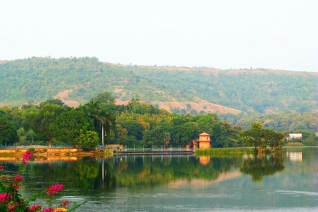
Banswara, often dubbed the ‘City of a Hundred Islands,’ earns its moniker as the ‘Cherrapunji of Rajasthan’ for being the state’s rainiest locale. This charming city is renowned not only for its annual downpours but also for the multitude of islands that dot the Mahi River, lovingly called ‘Mahati’ in the Vayu Purana text. This river gracefully winds its way through the heart of Banswara. With its lush greenery and verdant landscapes, Banswara proudly claims the title of being Rajasthan’s greenest city, all thanks to its generous rainfall, which not only quenches the earth’s thirst but also paints the town in vibrant shades of green.
History
Banswara, often referred to as ‘the bamboo city,’ was a Rajput feudatory state nestled in the heart of Rajputana during the British Indian era. This picturesque enclave shared its borders with Gujarat and was flanked to the north by the princely territories of Dungarpur and Udaipur, belonging to the revered Mewar region. To the northeast and east lay Partapgarh, while to the south, it shared boundaries with Holkar’s dominions and the state of Jabua. On its western front, Banswara found itself adjacent to the state of Rewa Kantha. This historical region boasted a rich tapestry of culture and heritage, steeped in Rajputana’s illustrious past.
Demography
“According to the 2001 Indian census,[12] the city of Banswara boasted a population of 101,177 individuals. In this demographic, males comprised 51% of the populace, while females made up the remaining 49%. Impressively, Banswara city displayed a commendable average literacy rate of 86.98%, significantly surpassing the national average of 59.5%. The gender disparity in literacy was notably low, with 92.76% of males and 81.01% of females achieving literacy. These statistics underscored the city’s commitment to education and empowerment, fostering a more equitable and enlightened society.
Geography
The landscape of this region is a tapestry of diverse terrain features. To the west of Banswara, the land undulates in short ridges, presenting a rugged topography. Conversely, the eastern part of the area is dominated by the presence of flat-topped hills characteristic of the Deccan plateau. At its southern extremity, the region melds with the Aravali mountain range. The primary drainage network is defined by the Mahi River, originating from the Amjera hills near Dhar in Madhya Pradesh. This river is nourished by several vital tributaries, including the Anas, Chanp, Erav, Hiran, and Kagdi, which collectively sculpt the region’s distinctive geographical profile.