Pincodes of Chittorgarh
Chittorgarh Pincodes Your Ultimate Guide to Locating Chittorgarh AddressesWelcome to “Pincodes of My Location,” your one-stop destination for all Chittorgarh pincodes. Chittorgarh, a city steeped in history and culture, boasts a diverse range of localities and neighborhoods. Finding the right pincode can be a breeze with our comprehensive database. Whether you’re sending a parcel, planning a visit, or simply exploring Chittorgarh, our user-friendly platform ensures you can access accurate information effortlessly. Navigate the city with ease, connect with locals, or order online—all by knowing the precise Chittorgarh pincode. Your gateway to seamless navigation starts right here at “Pincodes of My Location.”
Here is a list of Chittorgarh Pincodes
| No. | Location | Pincode | District | State |
|---|---|---|---|---|
| 1 | Achalawada | 312615 | Chittorgarh | Rajasthan |
| 2 | Achalpur | 312605 | Chittorgarh | Rajasthan |
| 3 | Achnera | 312615 | Chittorgarh | Rajasthan |
| 4 | Adana | 312203 | Chittorgarh | Rajasthan |
| 5 | Adityapuram | 312622 | Chittorgarh | Rajasthan |
| 6 | Akhepur | 312605 | Chittorgarh | Rajasthan |
| 7 | Akiya | 312001 | Chittorgarh | Rajasthan |
| 8 | Akola | 312205 | Chittorgarh | Rajasthan |
| 9 | Akola Kalan | 312024 | Chittorgarh | Rajasthan |
| 10 | Alod | 312404 | Chittorgarh | Rajasthan |
| 11 | Amarpura | 312022 | Chittorgarh | Rajasthan |
| 12 | Ambawali | 312604 | Chittorgarh | Rajasthan |
| 13 | Ambirama | 312613 | Chittorgarh | Rajasthan |
| 14 | Amlawad | 312605 | Chittorgarh | Rajasthan |
| 15 | Angona | 312605 | Chittorgarh | Rajasthan |
| 16 | Annuppura | 312621 | Chittorgarh | Rajasthan |
| 17 | Anoppura | 312202 | Chittorgarh | Rajasthan |
| 18 | Anushakti | 323303 | Chittorgarh | Rajasthan |
| 19 | Anwaleshwar | 312605 | Chittorgarh | Rajasthan |
| 20 | Anwalheda | 312022 | Chittorgarh | Rajasthan |
| 21 | Arned | 312402 | Chittorgarh | Rajasthan |
| 22 | Arni | 312203 | Chittorgarh | Rajasthan |
| 23 | Arnia Joshi | 312620 | Chittorgarh | Rajasthan |
| 24 | Arniapanth | 312612 | Chittorgarh | Rajasthan |
| 25 | Arnod | 312615 | Chittorgarh | Rajasthan |
| 26 | Arnoda | 312620 | Chittorgarh | Rajasthan |
| 27 | Asawara | 312602 | Chittorgarh | Rajasthan |
| 28 | Asawata | 312605 | Chittorgarh | Rajasthan |
| 29 | Babarana | 312204 | Chittorgarh | Rajasthan |
| 30 | Badolighata | 312601 | Chittorgarh | Rajasthan |
| 31 | Badolimadhosingh | 312601 | Chittorgarh | Rajasthan |
| 32 | Badoliya | 323307 | Chittorgarh | Rajasthan |
| 33 | Badwai | 312402 | Chittorgarh | Rajasthan |
| 34 | Badwal | 312401 | Chittorgarh | Rajasthan |
| 35 | Badwaskalan | 312615 | Chittorgarh | Rajasthan |
| 36 | Bagund | 312024 | Chittorgarh | Rajasthan |
| 37 | Bajranggarh | 312605 | Chittorgarh | Rajasthan |
| 38 | Balarada | 312202 | Chittorgarh | Rajasthan |
| 39 | Balkundikalan | 312023 | Chittorgarh | Rajasthan |
| 40 | Balvas | 312901 | Chittorgarh | Rajasthan |
| 41 | Bambori | 312614 | Chittorgarh | Rajasthan |
| 42 | Banakiyakalan | 312207 | Chittorgarh | Rajasthan |
| 43 | Bangreda | 312601 | Chittorgarh | Rajasthan |
| 44 | Bangreda Ghata | 312601 | Chittorgarh | Rajasthan |
| 45 | Bansen | 312001 | Chittorgarh | Rajasthan |
| 46 | Bansi | 312401 | Chittorgarh | Rajasthan |
| 47 | Banslai | 312613 | Chittorgarh | Rajasthan |
| 48 | Barawarda | 312616 | Chittorgarh | Rajasthan |
| 49 | Bardia | 312623 | Chittorgarh | Rajasthan |
| 50 | Bari | 312601 | Chittorgarh | Rajasthan |
| 51 | Barilank | 312605 | Chittorgarh | Rajasthan |
| 52 | Barisadari | 312403 | Chittorgarh | Rajasthan |
| 53 | Barisagthali | 312613 | Chittorgarh | Rajasthan |
| 54 | Barodia | 323307 | Chittorgarh | Rajasthan |
| 55 | Barotha | 312605 | Chittorgarh | Rajasthan |
| 56 | Baru | 312207 | Chittorgarh | Rajasthan |
| 57 | Basad | 312605 | Chittorgarh | Rajasthan |
| 58 | Basera | 312605 | Chittorgarh | Rajasthan |
| 59 | Bassi | 312022 | Chittorgarh | Rajasthan |
| 60 | Bedma | 312615 | Chittorgarh | Rajasthan |
| 61 | Begun | 312023 | Chittorgarh | Rajasthan |
| 62 | Bhabhanagar | 323307 | Chittorgarh | Rajasthan |
| 63 | Bhadesar | 312602 | Chittorgarh | Rajasthan |
| 64 | Bhadsaura | 312024 | Chittorgarh | Rajasthan |
| 65 | Bhagwanpura | 312614 | Chittorgarh | Rajasthan |
| 66 | Bhallundi | 312602 | Chittorgarh | Rajasthan |
| 67 | Bhalotha Ki kheri | 312206 | Chittorgarh | Rajasthan |
| 68 | Bhanuja | 312603 | Chittorgarh | Rajasthan |
| 69 | Bhatoli Bagrian | 312024 | Chittorgarh | Rajasthan |
| 70 | Bhatoli Brahmnan | 312403 | Chittorgarh | Rajasthan |
| 71 | Bhatton Ka bamniya | 312202 | Chittorgarh | Rajasthan |
| 72 | Bhawalia | 312620 | Chittorgarh | Rajasthan |
| 73 | Bhenshroadgarh | 323304 | Chittorgarh | Rajasthan |
| 74 | Bhichore | 312022 | Chittorgarh | Rajasthan |
| 75 | Bhimgarh | 312203 | Chittorgarh | Rajasthan |
| 76 | Bhopalnagar | 312204 | Chittorgarh | Rajasthan |
| 77 | Bhupalsagar | 312204 | Chittorgarh | Rajasthan |
| 78 | Bhuwasia | 312623 | Chittorgarh | Rajasthan |
| 79 | Bijaipur | 312026 | Chittorgarh | Rajasthan |
| 80 | Bilesari | 312605 | Chittorgarh | Rajasthan |
| 81 | Biloda | 312402 | Chittorgarh | Rajasthan |
| 82 | Binayaka | 312404 | Chittorgarh | Rajasthan |
| 83 | Binota | 312614 | Chittorgarh | Rajasthan |
| 84 | Boheda | 312404 | Chittorgarh | Rajasthan |
| 85 | Bolon Ka sanwata | 312901 | Chittorgarh | Rajasthan |
| 86 | Bood | 312901 | Chittorgarh | Rajasthan |
| 87 | Borav | 323304 | Chittorgarh | Rajasthan |
| 88 | Borda | 312901 | Chittorgarh | Rajasthan |
| 89 | Bori | 312616 | Chittorgarh | Rajasthan |
| 90 | Borikhera | 312616 | Chittorgarh | Rajasthan |
| 91 | Cement Factory | 312021 | Chittorgarh | Rajasthan |
| 92 | Chakunda | 312205 | Chittorgarh | Rajasthan |
| 93 | Chandera | 312613 | Chittorgarh | Rajasthan |
| 94 | Chanderia | 312021 | Chittorgarh | Rajasthan |
| 95 | Chenchi | 312023 | Chittorgarh | Rajasthan |
| 96 | Chhoti Sadari | 312604 | Chittorgarh | Rajasthan |
| 97 | Chhotisadri City | 312604 | Chittorgarh | Rajasthan |
| 98 | Chikarada | 312024 | Chittorgarh | Rajasthan |
| 99 | Chiklad | 312621 | Chittorgarh | Rajasthan |
| 100 | Chiksi | 312613 | Chittorgarh | Rajasthan |
| 101 | Chittorgarh | 312001 | Chittorgarh | Rajasthan |
| 102 | Chittorgarh Fort | 312001 | Chittorgarh | Rajasthan |
| 103 | Chogawadi | 312901 | Chittorgarh | Rajasthan |
| 104 | Chorwadi | 312205 | Chittorgarh | Rajasthan |
| 105 | Chupna | 312615 | Chittorgarh | Rajasthan |
| 106 | Collectorate chittorgarh | 312001 | Chittorgarh | Rajasthan |
| 107 | Dabda | 312605 | Chittorgarh | Rajasthan |
| 108 | Dalla (kishanpura) | 312601 | Chittorgarh | Rajasthan |
| 109 | Dalot | 312613 | Chittorgarh | Rajasthan |
| 110 | Damakhera | 312202 | Chittorgarh | Rajasthan |
| 111 | Daulatpura | 312023 | Chittorgarh | Rajasthan |
| 112 | Delwas | 312404 | Chittorgarh | Rajasthan |
| 113 | Deolia | 312621 | Chittorgarh | Rajasthan |
| 114 | Deopura | 312023 | Chittorgarh | Rajasthan |
| 115 | Deori | 312001 | Chittorgarh | Rajasthan |
| 116 | Dewad | 312605 | Chittorgarh | Rajasthan |
| 117 | Dhamana | 312202 | Chittorgarh | Rajasthan |
| 118 | Dhamancha | 312023 | Chittorgarh | Rajasthan |
| 119 | Dhamotore | 312616 | Chittorgarh | Rajasthan |
| 120 | Dhanet | 312024 | Chittorgarh | Rajasthan |
| 121 | Dhanet Kalan | 312201 | Chittorgarh | Rajasthan |
| 122 | Dheerji Ka khera | 312602 | Chittorgarh | Rajasthan |
| 123 | Dhiknia | 312616 | Chittorgarh | Rajasthan |
| 124 | Dhulapani | 312604 | Chittorgarh | Rajasthan |
| 125 | Dindoli | 312203 | Chittorgarh | Rajasthan |
| 126 | Doongla | 312402 | Chittorgarh | Rajasthan |
| 127 | Dorai | 312023 | Chittorgarh | Rajasthan |
| 128 | Doria | 312601 | Chittorgarh | Rajasthan |
| 129 | Dowani | 312202 | Chittorgarh | Rajasthan |
| 130 | Dudhli Tanda | 312616 | Chittorgarh | Rajasthan |
| 131 | Dugar | 312022 | Chittorgarh | Rajasthan |
| 132 | Eklingpura | 323307 | Chittorgarh | Rajasthan |
| 133 | Fathegarh | 312615 | Chittorgarh | Rajasthan |
| 134 | Gadola | 312623 | Chittorgarh | Rajasthan |
| 135 | Gagrol | 312604 | Chittorgarh | Rajasthan |
| 136 | Gandher | 312605 | Chittorgarh | Rajasthan |
| 137 | Ganeshpura | 312604 | Chittorgarh | Rajasthan |
| 138 | Gangrar | 312901 | Chittorgarh | Rajasthan |
| 139 | Gangrar r.s. | 312901 | Chittorgarh | Rajasthan |
| 140 | Gardana | 312603 | Chittorgarh | Rajasthan |
| 141 | Ghatiawali | 312612 | Chittorgarh | Rajasthan |
| 142 | Gilund | 312612 | Chittorgarh | Rajasthan |
| 143 | Gomana | 312604 | Chittorgarh | Rajasthan |
| 144 | Gopalpura | 323304 | Chittorgarh | Rajasthan |
| 145 | Gosunda | 312201 | Chittorgarh | Rajasthan |
| 146 | Gotarsi | 312605 | Chittorgarh | Rajasthan |
| 147 | Gulana | 312023 | Chittorgarh | Rajasthan |
| 148 | Gundli | 312205 | Chittorgarh | Rajasthan |
| 149 | Gyaspur | 312621 | Chittorgarh | Rajasthan |
| 150 | Harnathpur | 312203 | Chittorgarh | Rajasthan |
| 151 | Hathiyana | 312202 | Chittorgarh | Rajasthan |
| 152 | Hinglat | 312615 | Chittorgarh | Rajasthan |
| 153 | Hingoria | 312207 | Chittorgarh | Rajasthan |
| 154 | Idra | 312024 | Chittorgarh | Rajasthan |
| 155 | Industrial area chittorgarh | 312021 | Chittorgarh | Rajasthan |
| 156 | Jadana | 312203 | Chittorgarh | Rajasthan |
| 157 | Jainagar | 312023 | Chittorgarh | Rajasthan |
| 158 | Jajli | 312615 | Chittorgarh | Rajasthan |
| 159 | Jalampura | 312612 | Chittorgarh | Rajasthan |
| 160 | Jaliya | 312601 | Chittorgarh | Rajasthan |
| 161 | Jalkheda | 323307 | Chittorgarh | Rajasthan |
| 162 | Jaloda Jagir | 312614 | Chittorgarh | Rajasthan |
| 163 | Jalodia | 312604 | Chittorgarh | Rajasthan |
| 164 | Jarkhana | 312403 | Chittorgarh | Rajasthan |
| 165 | Jashma | 312202 | Chittorgarh | Rajasthan |
| 166 | Jawada 1 | 312023 | Chittorgarh | Rajasthan |
| 167 | Jawada ii | 312601 | Chittorgarh | Rajasthan |
| 168 | Jawahar Nagar | 326501 | Chittorgarh | Rajasthan |
| 169 | Jawasia | 312901 | Chittorgarh | Rajasthan |
| 170 | Jeerawata | 312613 | Chittorgarh | Rajasthan |
| 171 | Jhansri | 312605 | Chittorgarh | Rajasthan |
| 172 | Jitiya | 312207 | Chittorgarh | Rajasthan |
| 173 | Jojron Ka kheda | 312901 | Chittorgarh | Rajasthan |
| 174 | Jolar | 312621 | Chittorgarh | Rajasthan |
| 175 | Kachotiya | 312605 | Chittorgarh | Rajasthan |
| 176 | Kailash nagar | 312617 | Chittorgarh | Rajasthan |
| 177 | Kalyanpura | 312605 | Chittorgarh | Rajasthan |
| 178 | Kanad | 312615 | Chittorgarh | Rajasthan |
| 179 | Kanakhera | 312204 | Chittorgarh | Rajasthan |
| 180 | Kanera | 312606 | Chittorgarh | Rajasthan |
| 181 | Kangarh | 312613 | Chittorgarh | Rajasthan |
| 182 | Kankarwa | 312204 | Chittorgarh | Rajasthan |
| 183 | Kannoj | 312613 | Chittorgarh | Rajasthan |
| 184 | Kanora | 312623 | Chittorgarh | Rajasthan |
| 185 | Kanthariya Chobe ji ka | 312201 | Chittorgarh | Rajasthan |
| 186 | Kanti | 312901 | Chittorgarh | Rajasthan |
| 187 | Kapasan | 312202 | Chittorgarh | Rajasthan |
| 188 | Kapasan town | 312202 | Chittorgarh | Rajasthan |
| 189 | Karjali | 312205 | Chittorgarh | Rajasthan |
| 190 | Karju | 312403 | Chittorgarh | Rajasthan |
| 191 | Karsana | 312404 | Chittorgarh | Rajasthan |
| 192 | Karunda | 312620 | Chittorgarh | Rajasthan |
| 193 | Kashmore | 312201 | Chittorgarh | Rajasthan |
| 194 | Katunda | 312023 | Chittorgarh | Rajasthan |
| 195 | Keli | 312601 | Chittorgarh | Rajasthan |
| 196 | Kerwas | 312605 | Chittorgarh | Rajasthan |
| 197 | Kesharpura | 312623 | Chittorgarh | Rajasthan |
| 198 | Kesunda | 312604 | Chittorgarh | Rajasthan |
| 199 | Kewalpura | 312401 | Chittorgarh | Rajasthan |
| 200 | Kharkhanda | 312901 | Chittorgarh | Rajasthan |
| 201 | Khatikhera | 323307 | Chittorgarh | Rajasthan |
| 202 | Kheda | 312623 | Chittorgarh | Rajasthan |
| 203 | Kheranarsingh Mata | 312616 | Chittorgarh | Rajasthan |
| 204 | Kheri | 312022 | Chittorgarh | Rajasthan |
| 205 | Khermalia | 312603 | Chittorgarh | Rajasthan |
| 206 | Kherot | 312605 | Chittorgarh | Rajasthan |
| 207 | Kherpura | 312022 | Chittorgarh | Rajasthan |
| 208 | Kherudvala | 312403 | Chittorgarh | Rajasthan |
| 209 | Khodip | 312614 | Chittorgarh | Rajasthan |
| 210 | Khoria | 312623 | Chittorgarh | Rajasthan |
| 211 | Kiratpura | 312403 | Chittorgarh | Rajasthan |
| 212 | Kotri | 312615 | Chittorgarh | Rajasthan |
| 213 | Kotri Kalan | 312601 | Chittorgarh | Rajasthan |
| 214 | Kotwal | 312621 | Chittorgarh | Rajasthan |
| 215 | Kulthana | 312605 | Chittorgarh | Rajasthan |
| 216 | Kunni | 312605 | Chittorgarh | Rajasthan |
| 217 | Kunthana | 312024 | Chittorgarh | Rajasthan |
| 218 | Kunwalia | 312901 | Chittorgarh | Rajasthan |
| 219 | Kutchery Partabgarh | 312605 | Chittorgarh | Rajasthan |
| 220 | Lalgarh | 312615 | Chittorgarh | Rajasthan |
| 221 | Langach | 312207 | Chittorgarh | Rajasthan |
| 222 | Lasadiaya Kalan | 312206 | Chittorgarh | Rajasthan |
| 223 | Lasdawn | 312601 | Chittorgarh | Rajasthan |
| 224 | Laxmipura | 312403 | Chittorgarh | Rajasthan |
| 225 | Leswa | 312024 | Chittorgarh | Rajasthan |
| 226 | Lothiyana | 312024 | Chittorgarh | Rajasthan |
| 227 | Luharia | 312605 | Chittorgarh | Rajasthan |
| 228 | Madhura Talab | 312616 | Chittorgarh | Rajasthan |
| 229 | Magroda | 312623 | Chittorgarh | Rajasthan |
| 230 | Maharaaj Ki netawal | 312207 | Chittorgarh | Rajasthan |
| 231 | Mahuda | 312401 | Chittorgarh | Rajasthan |
| 232 | Mandawara | 312605 | Chittorgarh | Rajasthan |
| 233 | Mandawari | 312023 | Chittorgarh | Rajasthan |
| 234 | Mandesara | 323306 | Chittorgarh | Rajasthan |
| 235 | Mandfiya | 312901 | Chittorgarh | Rajasthan |
| 236 | Mandkalan | 312621 | Chittorgarh | Rajasthan |
| 237 | Mandla Charan | 312614 | Chittorgarh | Rajasthan |
| 238 | Mangalwar | 312024 | Chittorgarh | Rajasthan |
| 239 | Mangrol | 312620 | Chittorgarh | Rajasthan |
| 240 | Manohar Garh | 312605 | Chittorgarh | Rajasthan |
| 241 | Manpura Jagir | 312403 | Chittorgarh | Rajasthan |
| 242 | Marjivi | 312601 | Chittorgarh | Rajasthan |
| 243 | Marni | 312203 | Chittorgarh | Rajasthan |
| 244 | Meghniwas | 323304 | Chittorgarh | Rajasthan |
| 245 | Melana | 312601 | Chittorgarh | Rajasthan |
| 246 | Meriyakhedi | 312616 | Chittorgarh | Rajasthan |
| 247 | Metawal Garh pachholi | 312001 | Chittorgarh | Rajasthan |
| 248 | Mishron Ki pipli | 312201 | Chittorgarh | Rajasthan |
| 249 | Mohana | 323307 | Chittorgarh | Rajasthan |
| 250 | Moheda | 312615 | Chittorgarh | Rajasthan |
| 251 | Morwan | 312024 | Chittorgarh | Rajasthan |
| 252 | Mota Dhamaniya | 312605 | Chittorgarh | Rajasthan |
| 253 | Motikhedi | 312605 | Chittorgarh | Rajasthan |
| 254 | Motipura | 312022 | Chittorgarh | Rajasthan |
| 255 | Mowai | 312615 | Chittorgarh | Rajasthan |
| 256 | Mungana | 312204 | Chittorgarh | Rajasthan |
| 257 | Munjwa | 312403 | Chittorgarh | Rajasthan |
| 258 | Murla | 312205 | Chittorgarh | Rajasthan |
| 259 | Muroli | 312203 | Chittorgarh | Rajasthan |
| 260 | Nadakhera | 312024 | Chittorgarh | Rajasthan |
| 261 | Nagawali | 312024 | Chittorgarh | Rajasthan |
| 262 | Nagdi | 312615 | Chittorgarh | Rajasthan |
| 263 | Nagri | 312022 | Chittorgarh | Rajasthan |
| 264 | Nahargarh | 312613 | Chittorgarh | Rajasthan |
| 265 | Nakor | 312621 | Chittorgarh | Rajasthan |
| 266 | Nandwai | 312023 | Chittorgarh | Rajasthan |
| 267 | Nannana | 312614 | Chittorgarh | Rajasthan |
| 268 | Napania | 312024 | Chittorgarh | Rajasthan |
| 269 | Napawali | 312603 | Chittorgarh | Rajasthan |
| 270 | Narani | 312604 | Chittorgarh | Rajasthan |
| 271 | Narayankheda | 312616 | Chittorgarh | Rajasthan |
| 272 | Narela | 312207 | Chittorgarh | Rajasthan |
| 273 | Naugama | 312615 | Chittorgarh | Rajasthan |
| 274 | Nevaria | 312206 | Chittorgarh | Rajasthan |
| 275 | Nikumbh | 312603 | Chittorgarh | Rajasthan |
| 276 | Nilod | 312205 | Chittorgarh | Rajasthan |
| 277 | Nimbahera | 312601 | Chittorgarh | Rajasthan |
| 278 | Nimbahera r.s. | 312601 | Chittorgarh | Rajasthan |
| 279 | Ninor | 312613 | Chittorgarh | Rajasthan |
| 280 | Ochhari | 312001 | Chittorgarh | Rajasthan |
| 281 | Odund | 312201 | Chittorgarh | Rajasthan |
| 282 | Pachunda | 312023 | Chittorgarh | Rajasthan |
| 283 | Pahuna | 312206 | Chittorgarh | Rajasthan |
| 284 | Pal | 312022 | Chittorgarh | Rajasthan |
| 285 | Palasia | 312204 | Chittorgarh | Rajasthan |
| 286 | Palka | 312022 | Chittorgarh | Rajasthan |
| 287 | Palod | 312402 | Chittorgarh | Rajasthan |
| 288 | Pandawa | 312621 | Chittorgarh | Rajasthan |
| 289 | Pandoli S t | 312202 | Chittorgarh | Rajasthan |
| 290 | Pandolimataji Ki | 312201 | Chittorgarh | Rajasthan |
| 291 | Panmodi | 312623 | Chittorgarh | Rajasthan |
| 292 | Pari | 312204 | Chittorgarh | Rajasthan |
| 293 | Parliya | 312605 | Chittorgarh | Rajasthan |
| 294 | Parsoli | 312022 | Chittorgarh | Rajasthan |
| 295 | Partabgarh | 312605 | Chittorgarh | Rajasthan |
| 296 | Pateliya | 312605 | Chittorgarh | Rajasthan |
| 297 | Patoliya | 312205 | Chittorgarh | Rajasthan |
| 298 | Peelikheda | 312604 | Chittorgarh | Rajasthan |
| 299 | Peend | 312603 | Chittorgarh | Rajasthan |
| 300 | Phalodara | 312404 | Chittorgarh | Rajasthan |
| 301 | Phalwa | 312601 | Chittorgarh | Rajasthan |
| 302 | Piloo | 312623 | Chittorgarh | Rajasthan |
| 303 | Pipalwas | 312001 | Chittorgarh | Rajasthan |
| 304 | Pirana | 312402 | Chittorgarh | Rajasthan |
| 305 | Pithalwadikalan | 312604 | Chittorgarh | Rajasthan |
| 306 | Potlajagir | 312602 | Chittorgarh | Rajasthan |
| 307 | Punawali | 312603 | Chittorgarh | Rajasthan |
| 308 | Putholi | 312021 | Chittorgarh | Rajasthan |
| 309 | Raghunathpura | 312901 | Chittorgarh | Rajasthan |
| 310 | Raipur | 312613 | Chittorgarh | Rajasthan |
| 311 | Raipurjangal | 312613 | Chittorgarh | Rajasthan |
| 312 | Raita | 312023 | Chittorgarh | Rajasthan |
| 313 | Rajgarh | 312022 | Chittorgarh | Rajasthan |
| 314 | Rajpura | 323306 | Chittorgarh | Rajasthan |
| 315 | Rampuria | 312605 | Chittorgarh | Rajasthan |
| 316 | Ranasanga bazar chittorgarh | 312001 | Chittorgarh | Rajasthan |
| 317 | Ranikhera | 312601 | Chittorgarh | Rajasthan |
| 318 | Rashmi | 312203 | Chittorgarh | Rajasthan |
| 319 | Ratanpuria | 312605 | Chittorgarh | Rajasthan |
| 320 | Rathajana | 312623 | Chittorgarh | Rajasthan |
| 321 | Ratichandjikakhera | 312403 | Chittorgarh | Rajasthan |
| 322 | Rawarda | 312023 | Chittorgarh | Rajasthan |
| 323 | Rawatbhatta bazar | 323305 | Chittorgarh | Rajasthan |
| 324 | Rawatpura | 312402 | Chittorgarh | Rajasthan |
| 325 | Rewara | 312206 | Chittorgarh | Rajasthan |
| 326 | Rewlia Khurd | 312201 | Chittorgarh | Rajasthan |
| 327 | Richawara | 312605 | Chittorgarh | Rajasthan |
| 328 | Rolahera | 312021 | Chittorgarh | Rajasthan |
| 329 | Rolia | 312202 | Chittorgarh | Rajasthan |
| 330 | Rood | 312901 | Chittorgarh | Rajasthan |
| 331 | Sadalkhera | 312603 | Chittorgarh | Rajasthan |
| 332 | Sadarbazar chittorgarh | 312001 | Chittorgarh | Rajasthan |
| 333 | Sadas | 312901 | Chittorgarh | Rajasthan |
| 334 | Sadi | 312901 | Chittorgarh | Rajasthan |
| 335 | Sagathali Thana | 312615 | Chittorgarh | Rajasthan |
| 336 | Sainik School | 312021 | Chittorgarh | Rajasthan |
| 337 | Sakriya | 312623 | Chittorgarh | Rajasthan |
| 338 | Salamgarh | 312618 | Chittorgarh | Rajasthan |
| 339 | Samari | 312612 | Chittorgarh | Rajasthan |
| 340 | Samaria Khurd | 312023 | Chittorgarh | Rajasthan |
| 341 | Sangesara | 312024 | Chittorgarh | Rajasthan |
| 342 | Sangria | 312404 | Chittorgarh | Rajasthan |
| 343 | Sankhali | 312203 | Chittorgarh | Rajasthan |
| 344 | Sarsi | 312601 | Chittorgarh | Rajasthan |
| 345 | Satkhanda | 312612 | Chittorgarh | Rajasthan |
| 346 | Satola | 312403 | Chittorgarh | Rajasthan |
| 347 | Satpura | 312201 | Chittorgarh | Rajasthan |
| 348 | Sawa | 312613 | Chittorgarh | Rajasthan |
| 349 | Sehnwa | 312001 | Chittorgarh | Rajasthan |
| 350 | Selarpura Kalan | 312605 | Chittorgarh | Rajasthan |
| 351 | Semalpura | 312001 | Chittorgarh | Rajasthan |
| 352 | Semarthali | 312604 | Chittorgarh | Rajasthan |
| 353 | Semlia | 312001 | Chittorgarh | Rajasthan |
| 354 | Semlia Peela khera | 312402 | Chittorgarh | Rajasthan |
| 355 | Semnop | 312623 | Chittorgarh | Rajasthan |
| 356 | Senthi | 312001 | Chittorgarh | Rajasthan |
| 357 | Sewna | 312613 | Chittorgarh | Rajasthan |
| 358 | Shabhupura | 312612 | Chittorgarh | Rajasthan |
| 359 | Sidhpura | 312616 | Chittorgarh | Rajasthan |
| 360 | Sihana | 312206 | Chittorgarh | Rajasthan |
| 361 | Singhpur | 312207 | Chittorgarh | Rajasthan |
| 362 | Siyakhedi | 312604 | Chittorgarh | Rajasthan |
| 363 | Sonagar | 312022 | Chittorgarh | Rajasthan |
| 364 | Soniyana | 312901 | Chittorgarh | Rajasthan |
| 365 | Sripura | 323304 | Chittorgarh | Rajasthan |
| 366 | Subi | 312604 | Chittorgarh | Rajasthan |
| 367 | Sudri | 312901 | Chittorgarh | Rajasthan |
| 368 | Suhagpura | 312605 | Chittorgarh | Rajasthan |
| 369 | Sukhwara | 312613 | Chittorgarh | Rajasthan |
| 370 | Surajpole Partabgarh | 312605 | Chittorgarh | Rajasthan |
| 371 | Surpur | 312201 | Chittorgarh | Rajasthan |
| 372 | Suwania | 312901 | Chittorgarh | Rajasthan |
| 373 | Swaroopganj | 312604 | Chittorgarh | Rajasthan |
| 374 | Tambolia | 323304 | Chittorgarh | Rajasthan |
| 375 | Tana | 312205 | Chittorgarh | Rajasthan |
| 376 | Teela | 312616 | Chittorgarh | Rajasthan |
| 377 | Thada | 312623 | Chittorgarh | Rajasthan |
| 378 | Thukrai | 312023 | Chittorgarh | Rajasthan |
| 379 | Tumbadia | 312901 | Chittorgarh | Rajasthan |
| 380 | Uchnarkhurd | 312202 | Chittorgarh | Rajasthan |
| 381 | Udpura | 312620 | Chittorgarh | Rajasthan |
| 382 | Umand | 312205 | Chittorgarh | Rajasthan |
| 383 | Undwa | 312901 | Chittorgarh | Rajasthan |
| 384 | Unkliya | 312620 | Chittorgarh | Rajasthan |
| 385 | Untakheda | 312616 | Chittorgarh | Rajasthan |
| 386 | Unthel | 312613 | Chittorgarh | Rajasthan |
| 387 | Upreda | 312203 | Chittorgarh | Rajasthan |
| 388 | Usrol | 312204 | Chittorgarh | Rajasthan |
| 389 | Varmandal | 312605 | Chittorgarh | Rajasthan |
| 390 | Veerawali | 312615 | Chittorgarh | Rajasthan |
| 391 | Veerpur | 312605 | Chittorgarh | Rajasthan |
| 392 | Vikramgarh | 323306 | Chittorgarh | Rajasthan |
About Chittorghar
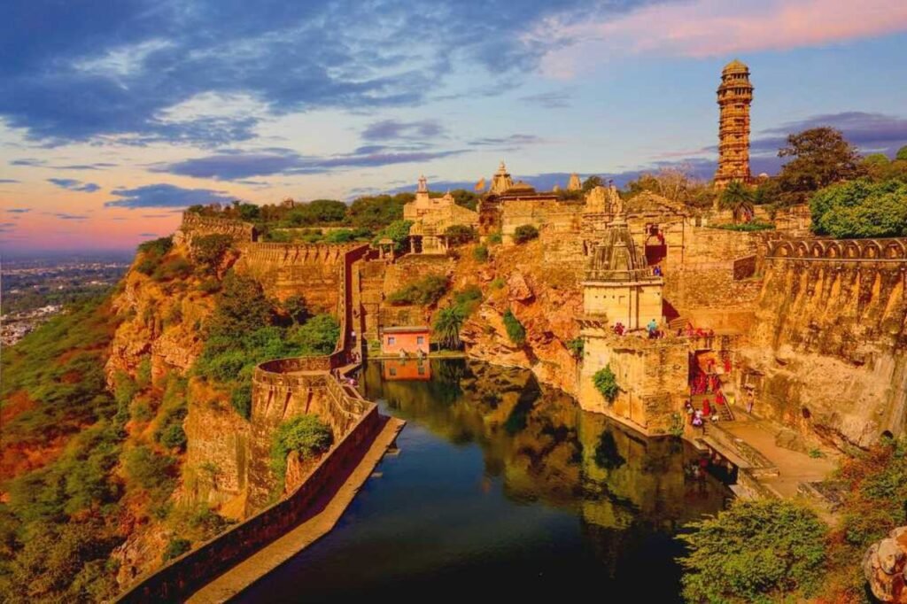
Chittorgarh, also known as Chittor or Chittaurgarh, is a significant urban center situated in western India’s Rajasthan state. Nestled along the Berach River, a tributary of the Banas, it serves as the administrative hub for Chittorgarh District. Historically, it played a pivotal role as a stronghold in the Rajput State of Medapata (modern Mewar). This historic city is positioned on the serene banks of both the Gambhiri and Berach rivers, lending it a rich cultural and geographical significance.
History
Once known as Chitrakuta, the Chittor Fort’s origins are attributed to its construction by Chitranga, a Mori king. Legend has it that Bappa Rawal, a Guhila (Gahlot) ruler, seized control of the fort around either 728 CE or 734 CE. Nonetheless, historical skepticism surrounds this narrative, as some scholars question the accuracy of this account, asserting that the Guhilas might not have ruled over Chittor until the reign of the later ruler, Allata. The intricate history of Chittor Fort continues to be a subject of intrigue, with debates persisting over the true origins of this iconic Rajasthani stronghold.
Demography
As of the 2011 census, Chittorgarh district boasted a population of 1,544,338, which is approximately equivalent to the entire nation of Gabon or the U.S. state of Hawaii in terms of population size. This places the district at the 323rd position in India’s population rankings, out of a total of 640 districts. Chittorgarh’s demographic statistics highlight its significance within the country and underscore its unique place in the Indian demographic landscape, contributing to the rich tapestry of diversity and culture that defines the nation.
Geography
Chittorgarh, situated at coordinates 24.88°N latitude and 74.63°E longitude, boasts an average elevation of 394 meters (1,292 feet). This historic city is nestled in the southern region of Rajasthan, in the northwestern expanse of India. It rests adjacent to a prominent hill, overlooking the tranquil Gambhiri River. Chittorgarh is geographically positioned between 23° 32′ and 25° 13′ north latitudes and 74° 12′ and 75° 49′ east longitudes, situated in the southeastern sector of the Rajasthan state. The district encompasses an area of 350.8 square kilometers, contributing 3.17 percent to the total land area of the Rajasthan state.
Economy
In 2006, Chittorgarh was designated as one of India’s 250 most economically disadvantaged districts by the Ministry of Panchayati Raj, within a total of 640 districts nationwide. Presently, Chittorgarh is among the twelve districts in the state of Rajasthan that benefit from financial assistance through the Backward Regions Grant Fund Programme (BRGF). This program aims to support and uplift regions facing economic challenges, facilitating their development and progress. Chittorgarh’s inclusion in this initiative underscores the government’s commitment to addressing socio-economic disparities and fostering growth in the district, thereby improving the quality of life for its residents.