Pincodes of Jalaun
Welcome to our Jalaun Pincodes database, your reliable source for locating the postal index numbers (PIN codes) of many localities in the ancient district of Jalaun, located in the northern Indian state of Uttar Pradesh. Jalaun is well-known for its cultural history, beautiful scenery, and thriving neighborhoods. PIN numbers are an important aspect of the postal system since they ensure the effective sorting and delivery of mail and shipments. Each locality in Jalaun is allocated a unique PIN code, which allows postal services to precisely route and deliver mail to its intended recipients. Using the correct PIN code is critical for ensuring that your mail is delivered on time.
Here is a list of Jalaun Pincodes
| No. | Location | Pincode | District | State |
|---|---|---|---|---|
| 1 | Abhedepur | 285130 | Jalaun | Uttar Pradesh |
| 2 | Aeir | 285001 | Jalaun | Uttar Pradesh |
| 3 | Aindha | 285223 | Jalaun | Uttar Pradesh |
| 4 | Ait | 285201 | Jalaun | Uttar Pradesh |
| 5 | Ajeetapur | 285129 | Jalaun | Uttar Pradesh |
| 6 | Aknewa | 285205 | Jalaun | Uttar Pradesh |
| 7 | Akorhi | 285201 | Jalaun | Uttar Pradesh |
| 8 | Akorhi Dubey | 285123 | Jalaun | Uttar Pradesh |
| 9 | Alipur | 285203 | Jalaun | Uttar Pradesh |
| 10 | Amkhera | 285123 | Jalaun | Uttar Pradesh |
| 11 | Anda | 285205 | Jalaun | Uttar Pradesh |
| 12 | Ata | 285202 | Jalaun | Uttar Pradesh |
| 13 | Atagaon | 285121 | Jalaun | Uttar Pradesh |
| 14 | Atarehati | 285121 | Jalaun | Uttar Pradesh |
| 15 | Atariya | 285123 | Jalaun | Uttar Pradesh |
| 16 | Atra Kalan | 285123 | Jalaun | Uttar Pradesh |
| 17 | Aurekhi | 285123 | Jalaun | Uttar Pradesh |
| 18 | Babai | 285123 | Jalaun | Uttar Pradesh |
| 19 | Babina | 285203 | Jalaun | Uttar Pradesh |
| 20 | Bagi | 285203 | Jalaun | Uttar Pradesh |
| 21 | Bahadurpur | 285124 | Jalaun | Uttar Pradesh |
| 22 | Bairai | 285204 | Jalaun | Uttar Pradesh |
| 23 | Bandhauli | 285122 | Jalaun | Uttar Pradesh |
| 24 | Bangra | 285121 | Jalaun | Uttar Pradesh |
| 25 | Baoni Estate | 285203 | Jalaun | Uttar Pradesh |
| 26 | Baragaon | 285001 | Jalaun | Uttar Pradesh |
| 27 | Barkhera | 285203 | Jalaun | Uttar Pradesh |
| 28 | Baroda Kalan | 285205 | Jalaun | Uttar Pradesh |
| 29 | Barsar | 285223 | Jalaun | Uttar Pradesh |
| 30 | Baseeth | 285206 | Jalaun | Uttar Pradesh |
| 31 | Basob | 285201 | Jalaun | Uttar Pradesh |
| 32 | Beerpura | 285001 | Jalaun | Uttar Pradesh |
| 33 | Beri | 285203 | Jalaun | Uttar Pradesh |
| 34 | Bhadari | 285205 | Jalaun | Uttar Pradesh |
| 35 | Bhadeikh | 285125 | Jalaun | Uttar Pradesh |
| 36 | Bhadreikhi | 285202 | Jalaun | Uttar Pradesh |
| 37 | Bhaoupura | 285128 | Jalaun | Uttar Pradesh |
| 38 | Bharsoonda | 285201 | Jalaun | Uttar Pradesh |
| 39 | Bhend | 285205 | Jalaun | Uttar Pradesh |
| 40 | Bhendi | 285203 | Jalaun | Uttar Pradesh |
| 41 | Bichauli | 285130 | Jalaun | Uttar Pradesh |
| 42 | Bilayan | 285201 | Jalaun | Uttar Pradesh |
| 43 | Bilond | 285124 | Jalaun | Uttar Pradesh |
| 44 | Binaura | 285223 | Jalaun | Uttar Pradesh |
| 45 | Birasni | 285201 | Jalaun | Uttar Pradesh |
| 46 | Birguwan Buzurg | 285201 | Jalaun | Uttar Pradesh |
| 47 | Birguwan Khurd | 285201 | Jalaun | Uttar Pradesh |
| 48 | Chaki | 285123 | Jalaun | Uttar Pradesh |
| 49 | Chamari | 285202 | Jalaun | Uttar Pradesh |
| 50 | Chamend | 285205 | Jalaun | Uttar Pradesh |
| 51 | Chandurra | 285201 | Jalaun | Uttar Pradesh |
| 52 | Chatela | 285203 | Jalaun | Uttar Pradesh |
| 53 | Chhani | 285205 | Jalaun | Uttar Pradesh |
| 54 | Chhiriya Salempur | 285123 | Jalaun | Uttar Pradesh |
| 55 | Chhonk | 285202 | Jalaun | Uttar Pradesh |
| 56 | Chilli | 285001 | Jalaun | Uttar Pradesh |
| 57 | Chitaura | 285126 | Jalaun | Uttar Pradesh |
| 58 | Churkhi | 285196 | Jalaun | Uttar Pradesh |
| 59 | Dakore | 285122 | Jalaun | Uttar Pradesh |
| 60 | Damras | 285130 | Jalaun | Uttar Pradesh |
| 61 | Daulatpur | 285125 | Jalaun | Uttar Pradesh |
| 62 | Deogaon | 285205 | Jalaun | Uttar Pradesh |
| 63 | Dhagwan Kalan | 285201 | Jalaun | Uttar Pradesh |
| 64 | Dhamna | 285126 | Jalaun | Uttar Pradesh |
| 65 | Dhanaura | 285001 | Jalaun | Uttar Pradesh |
| 66 | Dhantauli | 285001 | Jalaun | Uttar Pradesh |
| 67 | Dhoota | 285124 | Jalaun | Uttar Pradesh |
| 68 | Dhurat | 285201 | Jalaun | Uttar Pradesh |
| 69 | Diraoti | 285205 | Jalaun | Uttar Pradesh |
| 70 | Dvc Road orai | 285001 | Jalaun | Uttar Pradesh |
| 71 | Eekon | 285130 | Jalaun | Uttar Pradesh |
| 72 | Eeton | 285129 | Jalaun | Uttar Pradesh |
| 73 | Gadhela | 285123 | Jalaun | Uttar Pradesh |
| 74 | Gaindoli | 285206 | Jalaun | Uttar Pradesh |
| 75 | Garhar | 285001 | Jalaun | Uttar Pradesh |
| 76 | Garherna | 285121 | Jalaun | Uttar Pradesh |
| 77 | Garhgawan | 285123 | Jalaun | Uttar Pradesh |
| 78 | Garrehi | 285203 | Jalaun | Uttar Pradesh |
| 79 | Ghillaur | 285206 | Jalaun | Uttar Pradesh |
| 80 | Gohan | 285134 | Jalaun | Uttar Pradesh |
| 81 | Gopalpura | 285121 | Jalaun | Uttar Pradesh |
| 82 | Gora Bhoopka | 285128 | Jalaun | Uttar Pradesh |
| 83 | Gora Rathor | 285125 | Jalaun | Uttar Pradesh |
| 84 | Gulaoli | 285204 | Jalaun | Uttar Pradesh |
| 85 | Guraoti | 285205 | Jalaun | Uttar Pradesh |
| 86 | Gurha | 285122 | Jalaun | Uttar Pradesh |
| 87 | Hadrukh | 285128 | Jalaun | Uttar Pradesh |
| 88 | Harauli | 285126 | Jalaun | Uttar Pradesh |
| 89 | Harchandpur | 285203 | Jalaun | Uttar Pradesh |
| 90 | Hardoi Guzar | 285131 | Jalaun | Uttar Pradesh |
| 91 | Hatheri | 285123 | Jalaun | Uttar Pradesh |
| 92 | Imiliya | 285001 | Jalaun | Uttar Pradesh |
| 93 | Imiliya Buzurg | 285202 | Jalaun | Uttar Pradesh |
| 94 | Ingui | 285121 | Jalaun | Uttar Pradesh |
| 95 | Itahiya | 285123 | Jalaun | Uttar Pradesh |
| 96 | Itaura | 285231 | Jalaun | Uttar Pradesh |
| 97 | Jagammanpur | 285124 | Jalaun | Uttar Pradesh |
| 98 | Jaganpura | 285205 | Jalaun | Uttar Pradesh |
| 99 | Jagnewa | 285123 | Jalaun | Uttar Pradesh |
| 100 | Jaigha | 285124 | Jalaun | Uttar Pradesh |
| 101 | Jaisari Kalan | 285122 | Jalaun | Uttar Pradesh |
| 102 | Jaitpura | 285205 | Jalaun | Uttar Pradesh |
| 103 | Jakha | 285130 | Jalaun | Uttar Pradesh |
| 104 | Jakhauli | 285201 | Jalaun | Uttar Pradesh |
| 105 | Jalaun | 285123 | Jalaun | Uttar Pradesh |
| 106 | Jalaun Town | 285123 | Jalaun | Uttar Pradesh |
| 107 | Jamrohi Khurd | 285201 | Jalaun | Uttar Pradesh |
| 108 | Jugrajpura | 285121 | Jalaun | Uttar Pradesh |
| 109 | Kailiya | 285251 | Jalaun | Uttar Pradesh |
| 110 | Kailor | 285126 | Jalaun | Uttar Pradesh |
| 111 | Kainth | 285205 | Jalaun | Uttar Pradesh |
| 112 | Kakrau | 285203 | Jalaun | Uttar Pradesh |
| 113 | Kalpi | 285204 | Jalaun | Uttar Pradesh |
| 114 | Kalpi R.s. | 285204 | Jalaun | Uttar Pradesh |
| 115 | Kanasi | 285205 | Jalaun | Uttar Pradesh |
| 116 | Karamchandpur | 285202 | Jalaun | Uttar Pradesh |
| 117 | Karmer | 285001 | Jalaun | Uttar Pradesh |
| 118 | Kartalapur | 285128 | Jalaun | Uttar Pradesh |
| 119 | Kashirampur | 285204 | Jalaun | Uttar Pradesh |
| 120 | Keolari | 285123 | Jalaun | Uttar Pradesh |
| 121 | Khairi | 285205 | Jalaun | Uttar Pradesh |
| 122 | Khaksis | 285123 | Jalaun | Uttar Pradesh |
| 123 | Khanua | 285205 | Jalaun | Uttar Pradesh |
| 124 | Kharka | 285001 | Jalaun | Uttar Pradesh |
| 125 | Kharoosa | 285001 | Jalaun | Uttar Pradesh |
| 126 | Kharra | 285001 | Jalaun | Uttar Pradesh |
| 127 | Khutaila | 285205 | Jalaun | Uttar Pradesh |
| 128 | Kishunpura | 285205 | Jalaun | Uttar Pradesh |
| 129 | Konch | 285205 | Jalaun | Uttar Pradesh |
| 130 | Konch Bazariya | 285205 | Jalaun | Uttar Pradesh |
| 131 | Kotra | 285223 | Jalaun | Uttar Pradesh |
| 132 | Kudaari | 285121 | Jalaun | Uttar Pradesh |
| 133 | Kukargaon | 285001 | Jalaun | Uttar Pradesh |
| 134 | Kurahna Alamgir | 285202 | Jalaun | Uttar Pradesh |
| 135 | Kurkuru | 285223 | Jalaun | Uttar Pradesh |
| 136 | Kursenda | 285126 | Jalaun | Uttar Pradesh |
| 137 | Kusmara | 285123 | Jalaun | Uttar Pradesh |
| 138 | Kusmiliya | 285122 | Jalaun | Uttar Pradesh |
| 139 | Kuthond | 285125 | Jalaun | Uttar Pradesh |
| 140 | Kuthonda | 285121 | Jalaun | Uttar Pradesh |
| 141 | Kuthonda Buzurg | 285123 | Jalaun | Uttar Pradesh |
| 142 | Lahchura | 285123 | Jalaun | Uttar Pradesh |
| 143 | Lamsar | 285203 | Jalaun | Uttar Pradesh |
| 144 | Lidaupur | 285124 | Jalaun | Uttar Pradesh |
| 145 | Lohagarh | 285205 | Jalaun | Uttar Pradesh |
| 146 | Lohai | 285125 | Jalaun | Uttar Pradesh |
| 147 | Madaripur | 285130 | Jalaun | Uttar Pradesh |
| 148 | Madhogarh | 285126 | Jalaun | Uttar Pradesh |
| 149 | Madora | 285128 | Jalaun | Uttar Pradesh |
| 150 | Madori | 285128 | Jalaun | Uttar Pradesh |
| 151 | Magraul | 285204 | Jalaun | Uttar Pradesh |
| 152 | Mahewa | 285211 | Jalaun | Uttar Pradesh |
| 153 | Mai | 285124 | Jalaun | Uttar Pradesh |
| 154 | Mainupur | 285204 | Jalaun | Uttar Pradesh |
| 155 | Majeeth | 285129 | Jalaun | Uttar Pradesh |
| 156 | Mandri | 285001 | Jalaun | Uttar Pradesh |
| 157 | Manpura | 285121 | Jalaun | Uttar Pradesh |
| 158 | Margayan | 285203 | Jalaun | Uttar Pradesh |
| 159 | Masgaon | 285202 | Jalaun | Uttar Pradesh |
| 160 | Matra | 285203 | Jalaun | Uttar Pradesh |
| 161 | Mawai Ahir | 285203 | Jalaun | Uttar Pradesh |
| 162 | Mijhauna | 285121 | Jalaun | Uttar Pradesh |
| 163 | Mohammedabad | 285122 | Jalaun | Uttar Pradesh |
| 164 | Mohana | 285122 | Jalaun | Uttar Pradesh |
| 165 | Musmariya | 285123 | Jalaun | Uttar Pradesh |
| 166 | Nadai | 285123 | Jalaun | Uttar Pradesh |
| 167 | Nadigaon | 285206 | Jalaun | Uttar Pradesh |
| 168 | Nahili | 285125 | Jalaun | Uttar Pradesh |
| 169 | Naoli | 285121 | Jalaun | Uttar Pradesh |
| 170 | Naraul | 285127 | Jalaun | Uttar Pradesh |
| 171 | Navin Mandi konch | 285205 | Jalaun | Uttar Pradesh |
| 172 | Nawar | 285129 | Jalaun | Uttar Pradesh |
| 173 | Nibahna | 285204 | Jalaun | Uttar Pradesh |
| 174 | Ninaoli | 285127 | Jalaun | Uttar Pradesh |
| 175 | Nipaniya | 285130 | Jalaun | Uttar Pradesh |
| 176 | Nunsai | 285001 | Jalaun | Uttar Pradesh |
| 177 | Orai | 285001 | Jalaun | Uttar Pradesh |
| 178 | Orai Kutchery | 285001 | Jalaun | Uttar Pradesh |
| 179 | Orai Railway station | 285001 | Jalaun | Uttar Pradesh |
| 180 | Orai Town | 285001 | Jalaun | Uttar Pradesh |
| 181 | Pachipuri | 285205 | Jalaun | Uttar Pradesh |
| 182 | Pachokhara | 285127 | Jalaun | Uttar Pradesh |
| 183 | Paniyara | 285205 | Jalaun | Uttar Pradesh |
| 184 | Parasan | 285202 | Jalaun | Uttar Pradesh |
| 185 | Parawar | 285121 | Jalaun | Uttar Pradesh |
| 186 | Parwatpura | 285123 | Jalaun | Uttar Pradesh |
| 187 | Patrahi | 285124 | Jalaun | Uttar Pradesh |
| 188 | Pindari | 285201 | Jalaun | Uttar Pradesh |
| 189 | Piprayan | 285202 | Jalaun | Uttar Pradesh |
| 190 | Pipri Athgaiyan | 285130 | Jalaun | Uttar Pradesh |
| 191 | Pipri Gaharwar | 285125 | Jalaun | Uttar Pradesh |
| 192 | Pirona | 285201 | Jalaun | Uttar Pradesh |
| 193 | Pratap-pura | 285123 | Jalaun | Uttar Pradesh |
| 194 | Rahiya | 285001 | Jalaun | Uttar Pradesh |
| 195 | Ramhetpura | 285126 | Jalaun | Uttar Pradesh |
| 196 | Rampura | 285127 | Jalaun | Uttar Pradesh |
| 197 | Rampura Kirwaha | 285125 | Jalaun | Uttar Pradesh |
| 198 | Rath Road orai | 285001 | Jalaun | Uttar Pradesh |
| 199 | Rendhar | 285121 | Jalaun | Uttar Pradesh |
| 200 | Rirua | 285202 | Jalaun | Uttar Pradesh |
| 201 | Romai Mustkil | 285125 | Jalaun | Uttar Pradesh |
| 202 | Roora Addu | 285001 | Jalaun | Uttar Pradesh |
| 203 | Roora Jaitia | 285125 | Jalaun | Uttar Pradesh |
| 204 | Rudrapura | 285127 | Jalaun | Uttar Pradesh |
| 205 | Rura Sirsa | 285121 | Jalaun | Uttar Pradesh |
| 206 | Sadupura | 285205 | Jalaun | Uttar Pradesh |
| 207 | Sahav | 285123 | Jalaun | Uttar Pradesh |
| 208 | Said Nagar | 285223 | Jalaun | Uttar Pradesh |
| 209 | Sajera | 285206 | Jalaun | Uttar Pradesh |
| 210 | Salabad | 285123 | Jalaun | Uttar Pradesh |
| 211 | Salaiyya Buzurg | 285205 | Jalaun | Uttar Pradesh |
| 212 | Sami | 285205 | Jalaun | Uttar Pradesh |
| 213 | Sandhi | 285202 | Jalaun | Uttar Pradesh |
| 214 | Sarawan | 285123 | Jalaun | Uttar Pradesh |
| 215 | Sarr | 285121 | Jalaun | Uttar Pradesh |
| 216 | Sarsai | 285123 | Jalaun | Uttar Pradesh |
| 217 | Sarsela | 285202 | Jalaun | Uttar Pradesh |
| 218 | Satoh | 285201 | Jalaun | Uttar Pradesh |
| 219 | Shahjadpura | 285001 | Jalaun | Uttar Pradesh |
| 220 | Shahjahanpur | 285202 | Jalaun | Uttar Pradesh |
| 221 | Shankarpur | 285125 | Jalaun | Uttar Pradesh |
| 222 | Sheikhpur Ahir | 285125 | Jalaun | Uttar Pradesh |
| 223 | Sheikhpur Buzurg | 285128 | Jalaun | Uttar Pradesh |
| 224 | Sidhpura | 285127 | Jalaun | Uttar Pradesh |
| 225 | Sihari | 285126 | Jalaun | Uttar Pradesh |
| 226 | Sihari Daoodpur | 285001 | Jalaun | Uttar Pradesh |
| 227 | Sikri Raja | 285123 | Jalaun | Uttar Pradesh |
| 228 | Sikri Vyas | 285223 | Jalaun | Uttar Pradesh |
| 229 | Simhara Kasimpur | 285130 | Jalaun | Uttar Pradesh |
| 230 | Sirsa Dogarhi | 285121 | Jalaun | Uttar Pradesh |
| 231 | Sirsa Kalar | 285130 | Jalaun | Uttar Pradesh |
| 232 | Somai | 285201 | Jalaun | Uttar Pradesh |
| 233 | Sunaya | 285205 | Jalaun | Uttar Pradesh |
| 234 | Teehar | 285127 | Jalaun | Uttar Pradesh |
| 235 | Tikri | 285125 | Jalaun | Uttar Pradesh |
| 236 | Timron | 285001 | Jalaun | Uttar Pradesh |
| 237 | Titra Khalilpur | 285205 | Jalaun | Uttar Pradesh |
| 238 | Toomra | 285205 | Jalaun | Uttar Pradesh |
| 239 | Udanpur | 285203 | Jalaun | Uttar Pradesh |
| 240 | Umri | 285129 | Jalaun | Uttar Pradesh |
| 241 | Uncha | 285127 | Jalaun | Uttar Pradesh |
| 242 | Urgaon | 285123 | Jalaun | Uttar Pradesh |
| 243 | Usargaon | 285202 | Jalaun | Uttar Pradesh |
| 244 | Waoli | 285125 | Jalaun | Uttar Pradesh |
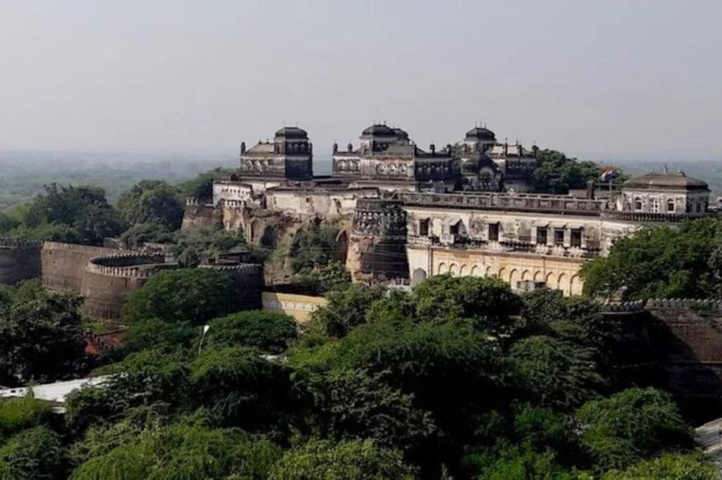
About Jalaun
Jalaun district, located in Uttar Pradesh, India, takes its name from the town of Jalaun, once the seat of a Maratha governor. However, the administrative center of the district is currently situated in the town of Orai.
History
Jalaun District boasts a rich historical tapestry. The region initially flourished under the rule of the Chandelas and later the Muslim rulers of Delhi. The 16th century saw it become part of the Mughal Empire, witnessing significant development. In the 18th century, Jalaun’s fate intertwined with the Marathas, who established their governance, leaving behind a blend of cultural and architectural influences.
The British era marked another chapter, with Jalaun playing a role in the Indian Rebellion of 1857. Following India’s independence in 1947, Jalaun became part of the newly formed state of Uttar Pradesh. The district, through its journey from ancient dynasties to modern times, reflects a mosaic of cultural and historical changes. Its legacy is visible in its architecture, traditions, and the resilience of its people, making Jalaun a district with a story that mirrors the broader narrative of India’s rich history.
Geography:
Jalaun District, part of Uttar Pradesh’s Jhansi Division, covers an area of 4,565 km². As per the 2011 census, it has a population of around 1.69 million, with a density of 370 people per km². Geographically, the district is characterized by the flat plains of Bundelkhand, north of the hilly regions. It’s almost encircled by the Yamuna River to the north, with its tributaries, the Betwa to the south and the Pahuj to the west, forming natural boundaries.
The heart of Jalaun is a vast expanse of cultivated land, notable for its sparse tree cover and dotted with villages. The southern part is a continuous stretch of agriculture. The Non River cuts through the district, creating several small ravines. Surrounding Jalaun are the districts of Etawah and Kanpur to the north across the Yamuna, Hamirpur to the east and southeast, Jhansi to the southeast, and Madhya Pradesh’s Bhind District to the west, across the Pahuj.
Economy:
Jalaun District showcases a predominantly agrarian economy. The fertile plains of Bundelkhand, which encompass the district, are ideal for farming, and as a result, agriculture is the mainstay of the local economy. Farmers in Jalaun primarily cultivate a variety of crops, including wheat, pulses, and oilseeds, leveraging the benefits of the region’s rich soil and favorable climate.
Besides agriculture, small-scale industries contribute to the district’s economic landscape. These industries include manufacturing, handicrafts, and the processing of agricultural products. The district’s markets are bustling with local produce and handicrafts, reflecting the entrepreneurial spirit of its residents.
Jalaun’s economy is also supported by its livestock and dairy sectors, which are integral to rural livelihoods. In recent years, there has been a gradual shift towards diversifying the economy with the introduction of new technologies and practices in agriculture and small industries. This evolution reflects the district’s adaptation to modern economic trends while staying rooted in its traditional economic practices.
Demography
As of the 2011 census, Jalaun District’s population stood at 1,689,974, placing it 296th among India’s 640 districts. Its population density is 366 people per square kilometer. The gender ratio in Jalaun is 865 females to every 1000 males, and the literacy rate is 75.16%. Nearly a quarter of the population, about 24.79%, resides in urban areas. Orai is the largest city in the district, followed by Konch.
Language-wise, 96.64% of the district’s residents primarily speak Hindi. Bundeli, a local dialect, is spoken by 2.01% of the population, while 1.30% speak Urdu as their first language.