Latehar Pincodes
Enter the Pincode or Location Below in the Box
Latehar Pincodes
Latehar Pincodes is your ultimate source for precise postal codes within Latehar’s picturesque district. Nestled in Jharkhand, Latehar boasts a rich cultural heritage and scenic landscapes. The district comprises several tehsils and blocks, fostering vibrant communities and diverse neighborhoods. It’s home to lush forests, enhancing its natural allure. Our platform streamlines your search for accurate postal codes, ensuring seamless mail delivery and package logistics across this stunning region.Latehar Pincodes simplifies locating specific areas, enabling efficient correspondence and navigation through this vibrant district’s varied locales.
Here is a list of Latehar Pincodes
About Latehar District
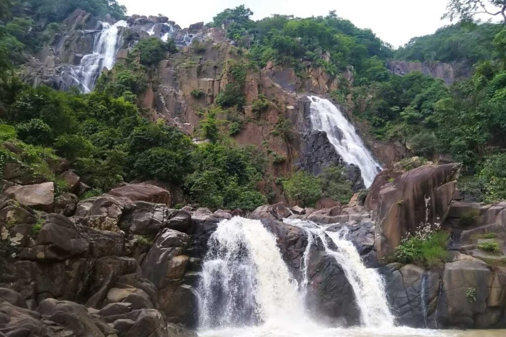
Latehar, headquarters of Latehar district in Jharkhand, epitomizes natural splendor, renowned for its lush forests, mineral reserves, and scenic beauty. Formerly a subdivision under Palamau District since 1924, it gained district status on April 4, 2001, per Jharkhand Government Notification No 946. Positioned in the north-west of Jharkhand within the Palamau Commissionary, Latehar borders Ranchi, Lohardaga, Gumla, Palamu, Chatra districts, and Chhattisgarh. With a vast tribal populace, around 45.54% are indigenous tribes, constituting over 66% of the total population. Spanning 3,622.50 km², the district’s remoteness extends to block headquarters, located over 200 km away. Notably, Jharkhand’s second-largest waterfall graces the lands of Latehar.
History
Palamu’s early history is veiled in legends, its forested terrain keeping it beyond invading armies’ sights, unscathed by neighboring empires in modern Bihar. Indigenous tribes like the Kharwars, Oraons, and Cheros inhabited this region, showcasing a surprisingly advanced civilization despite dense jungles. Inscriptions and artifacts hint at this development. The Oraons centered in Rohtas Garh, part of Shahabad district, potentially extending rule into Palamu. The Cheros, ruling for about 200 years, saw Medni Rai assert dominance over parts of Gaya, Hazaribag, and Surguja. His son, Pratap Rai, erected a distinct fort in Palamu, continuing the legacy of his father’s reign.
Demography
By the 2011 India census, Latehar recorded a population of 864,677, with males comprising 53% and females 47%. The district boasts an average literacy rate of 61%, surpassing the national average of 59.5%. Male literacy stands at 70%, while female literacy is 51%. Within Latehar, 15% of the population is under 6 years old, highlighting a youthful demographic. These statistics reflect the district’s strides in education, with a relatively higher literacy rate compared to the national average, showcasing a commitment to empowering its inhabitants through education and fostering a promising future generation.
Geography
Latehar district is renowned for hosting Jharkhand’s tallest waterfalls—Lodh Falls and Lower Ghaghri Falls, among various others. It boasts Netarhat, a charming hill station captivating visitors with its scenic beauty. The district also houses the esteemed Betla National Park and the Mahuadanr Wolf Sanctuary, both cherished havens for wildlife enthusiasts. Latehar is a treasure trove of natural wonders, offering breathtaking landscapes and diverse ecosystems. Its cascading waterfalls, serene hill station, and vital wildlife reserves make it a coveted destination for nature lovers, adding to the district’s allure and appeal as a haven for natural splendor in Jharkhand.
Economy
In 2006, the Indian government identified Latehar among the 250 most underdeveloped districts out of 640 nationwide. Positioned in Jharkhand, Latehar is a recipient of support through the Backward Regions Grant Fund Programme (BRGF). This initiative aims to uplift districts facing socio-economic challenges, allocating funds for comprehensive development. The district’s inclusion in this program signifies concerted efforts towards bolstering infrastructure, education, and socio-economic growth. Through BRGF assistance, Latehar endeavors to surmount developmental hurdles, fostering progress, and enhancing the quality of life for its residents, marking a dedicated stride towards holistic advancement within the region.