Kargil Pincodes
Enter the Pincode or Location Below in the Box
Kargil Pincodes
Kargil pincodes categorize the diverse landscapes of this region in Ladakh, India. Ranging from 194103 to 194106, these pincodes delineate areas spanning from the vibrant townships to the serene villages. Each pincode symbolizes a specific geographic area, encompassing Kargil’s cultural richness and geographical expanse. The pincodes facilitate efficient mail delivery and geographical classification, crucial in navigating the varied terrain of this scenic and historically significant district.
Here is a list of Kargil Pincodes
About Kargil District
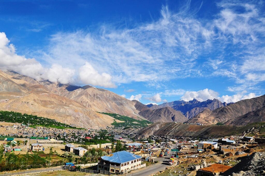
Kargil, alternatively known as Kargyil, stands as a pivotal city within Indian-administered Ladakh, situated in the Kashmir region. Serving as the shared capital of Ladakh, a union territory under Indian administration, it also holds the distinction of being the administrative center of the Kargil district. Notably, it ranks as the second-largest urban settlement in Ladakh, trailing only behind Leh. Positioned approximately 204 kilometers east of Srinagar in Jammu and Kashmir and 234 kilometers west of Leh, Kargil rests alongside the Suru River, close to its merging point with the Wakha Rong river, serving as a primary route to Leh.
History
The First Kashmir War (1947–48) established a ceasefire line, dividing Ladakh into Indian and Pakistani territories. India upgraded Kargil and Leh to districts within Ladakh, mirroring Jammu and Kashmir divisions. Pakistan renamed its portion Baltistan, creating further districts. The Simla Agreement after the 1971 Indo-Pakistani War transformed the ceasefire line into the Line of Control, aiming to prevent armed conflict. In 1999, Pakistani infiltration sparked the Kargil War, spanning 160 km of high ridges overseeing the Srinagar-Leh road. Following intense fighting and diplomatic efforts, Pakistani forces withdrew upon Prime Minister Nawaz Sharif’s visit to the USA, adhering to the Line of Control.
Demography
In the 2011 census, Kargil town counted 16,338 residents, primarily composed of Scheduled Tribes, numbering 11,496. The literacy rate stood at 75%. Islam emerged as the dominant religion, embraced by 77.56% of Kargil’s populace. Hinduism followed with 19.21%, while Buddhism and Sikhism constituted 0.54% and 2.2% respectively. This religious diversity underscores the town’s rich cultural tapestry, showcasing a blend of Islamic and Hindu traditions alongside smaller yet significant Buddhist and Sikh communities within its vibrant social fabric.
Geography
Kargil rests at an altitude averaging 2,676 meters (8,780 feet), nestled by the Suru River (part of the Indus), about 205 kilometers (127 miles) from Srinagar. Positioned across the LOC, facing the Northern Areas, this town boasts a typical Himalayan climate. Summers bring heat during the day, followed by pleasantly cool nights. In contrast, winters endure a lengthy spell of frigidity, with temperatures frequently plummeting below −20 °C (−4 °F). The terrain’s beauty intertwines with the challenging weather, defining Kargil’s allure. Its high elevation not only offers breathtaking vistas but also blankets the region in a wintry embrace for extended periods.
Administration
Kargil is administratively segmented into 12 Niabats and four Sub-Divisions: Kargil, Zanskar, Sankoo, and Shakar-Chiktan, along with seven Tehsils. The Ladakh Autonomous Hill Development Council, formed in 2003, reshaped its structure with 26 elected and 4 nominated Councilors. The Chairman, akin to a Cabinet Minister, oversees the Council’s functions, including passing plans and budgets, and sanctioning projects up to Rs 5 Crores. Additionally, four Executive Councilors hold Deputy Minister rank. The Deputy Commissioner of Kargil, serving as the administrative head and CEO of the Hill Council, manages the administrative framework and upholds law and order.