Pincodes of Murshidabad
Greetings and welcome to the Murshidabad Pincodes directory, your go-to resource for precise postal codes in the historically notable Murshidabad area. Whether you’re a visitor, a business owner, or a resident, our easy-to-use tool can help you quickly obtain precise pincode information. Every town, village, and hamlet in Murshidabad has a postal index number (PIN), which is a special code. PINs are necessary to guarantee timely mail delivery, accurate location tracking, and smooth communication. You can quickly look up pincodes in Murshidabad by name, neighborhood, or other criteria using our directory.
Here is a list of Murshidabad Pincodes
| Location | Pincode | District | State | |
|---|---|---|---|---|
| 1 | Adibasi Beldanga | 742122 | Murshidabad | West Bengal |
| 2 | Adikantanagar | 742227 | Murshidabad | West Bengal |
| 3 | Aheripara | 742226 | Murshidabad | West Bengal |
| 4 | Ahiran | 742234 | Murshidabad | West Bengal |
| 5 | Ajgarpara | 742223 | Murshidabad | West Bengal |
| 6 | Akheriganj | 742135 | Murshidabad | West Bengal |
| 7 | Alampur | 742223 | Murshidabad | West Bengal |
| 8 | Alamsahi | 742224 | Murshidabad | West Bengal |
| 9 | Alugram | 742301 | Murshidabad | West Bengal |
| 10 | Amaipara | 742113 | Murshidabad | West Bengal |
| 11 | Amdahara | 742113 | Murshidabad | West Bengal |
| 12 | Aminabad | 742406 | Murshidabad | West Bengal |
| 13 | Amlai | 742301 | Murshidabad | West Bengal |
| 14 | Amritakunda | 742136 | Murshidabad | West Bengal |
| 15 | Amtala | 742121 | Murshidabad | West Bengal |
| 16 | Amtala (mobile) | 742202 | Murshidabad | West Bengal |
| 17 | Anantapur | 742202 | Murshidabad | West Bengal |
| 18 | Andi | 742168 | Murshidabad | West Bengal |
| 19 | Andulia | 742138 | Murshidabad | West Bengal |
| 20 | Arjunpur | 742231 | Murshidabad | West Bengal |
| 21 | Ashariadaha | 742148 | Murshidabad | West Bengal |
| 22 | Atai | 742157 | Murshidabad | West Bengal |
| 23 | Aurangabad | 742201 | Murshidabad | West Bengal |
| 24 | Ayra | 742147 | Murshidabad | West Bengal |
| 25 | Azimganj | 742122 | Murshidabad | West Bengal |
| 26 | B.Durlavpur | 742302 | Murshidabad | West Bengal |
| 27 | B.Sahazadpur | 742187 | Murshidabad | West Bengal |
| 28 | B.Sherpur | 742301 | Murshidabad | West Bengal |
| 29 | Babultali | 742308 | Murshidabad | West Bengal |
| 30 | Bachra | 742163 | Murshidabad | West Bengal |
| 31 | Badua | 742147 | Murshidabad | West Bengal |
| 32 | Bagdabra | 742212 | Murshidabad | West Bengal |
| 33 | Bagdanga | 742138 | Murshidabad | West Bengal |
| 34 | Bagore | 742136 | Murshidabad | West Bengal |
| 35 | Bahadurpur | 742135 | Murshidabad | West Bengal |
| 36 | Bahadurpur Roypur | 742223 | Murshidabad | West Bengal |
| 37 | Bahagalpur | 742202 | Murshidabad | West Bengal |
| 38 | Bahara | 742138 | Murshidabad | West Bengal |
| 39 | Bajupur Madhupur | 742148 | Murshidabad | West Bengal |
| 40 | Balarampore Colony | 742165 | Murshidabad | West Bengal |
| 41 | Balia | 742237 | Murshidabad | West Bengal |
| 42 | Baligokulpur | 742302 | Murshidabad | West Bengal |
| 43 | Bamnabad | 742306 | Murshidabad | West Bengal |
| 44 | Banjetia | 742102 | Murshidabad | West Bengal |
| 45 | Bansgara | 742148 | Murshidabad | West Bengal |
| 46 | Barala | 742235 | Murshidabad | West Bengal |
| 47 | Barasimul | 742213 | Murshidabad | West Bengal |
| 48 | Barjumla | 742148 | Murshidabad | West Bengal |
| 49 | Barua | 742109 | Murshidabad | West Bengal |
| 50 | Baruipara | 742165 | Murshidabad | West Bengal |
| 51 | Barwan | 742132 | Murshidabad | West Bengal |
| 52 | Basantpur | 742406 | Murshidabad | West Bengal |
| 53 | Basudebkhali | 742187 | Murshidabad | West Bengal |
| 54 | Bazarshaw | 742163 | Murshidabad | West Bengal |
| 55 | Begunbari | 742133 | Murshidabad | West Bengal |
| 56 | Beharia | 742175 | Murshidabad | West Bengal |
| 57 | Beldanga | 742133 | Murshidabad | West Bengal |
| 58 | Belgram | 742168 | Murshidabad | West Bengal |
| 59 | Beniagram | 742212 | Murshidabad | West Bengal |
| 60 | Benipur | 742140 | Murshidabad | West Bengal |
| 61 | Berhampore (wb) | 742101 | Murshidabad | West Bengal |
| 62 | Berhampore Civil court | 742101 | Murshidabad | West Bengal |
| 63 | Berhampore Station road | 742101 | Murshidabad | West Bengal |
| 64 | Bewa | 742212 | Murshidabad | West Bengal |
| 65 | Bezpara Saluadanga | 742134 | Murshidabad | West Bengal |
| 66 | Bhabanipur | 742202 | Murshidabad | West Bengal |
| 67 | Bhabta | 742134 | Murshidabad | West Bengal |
| 68 | Bhadur | 742134 | Murshidabad | West Bengal |
| 69 | Bhagabangola | 742135 | Murshidabad | West Bengal |
| 70 | Bhagabangola Sundarpur | 742135 | Murshidabad | West Bengal |
| 71 | Bhagirathpur | 742406 | Murshidabad | West Bengal |
| 72 | Bhairabpur | 742302 | Murshidabad | West Bengal |
| 73 | Bhalanagar | 742121 | Murshidabad | West Bengal |
| 74 | Bhalkundi | 742157 | Murshidabad | West Bengal |
| 75 | Bhandara | 742113 | Murshidabad | West Bengal |
| 76 | Bharatpur | 742301 | Murshidabad | West Bengal |
| 77 | Bhasai Paikar | 742202 | Murshidabad | West Bengal |
| 78 | Bhattabati | 742149 | Murshidabad | West Bengal |
| 79 | Bhola | 742226 | Murshidabad | West Bengal |
| 80 | Bilaspur | 742303 | Murshidabad | West Bengal |
| 81 | Bilbora Kopra | 742148 | Murshidabad | West Bengal |
| 82 | Bilcolony | 742181 | Murshidabad | West Bengal |
| 83 | Binodia | 742301 | Murshidabad | West Bengal |
| 84 | Bipra Sekhar | 742168 | Murshidabad | West Bengal |
| 85 | Bishannagar | 742133 | Murshidabad | West Bengal |
| 86 | Bishnupur Kalibari | 742102 | Murshidabad | West Bengal |
| 87 | Boaliadanga | 742102 | Murshidabad | West Bengal |
| 88 | Boincuitala | 742302 | Murshidabad | West Bengal |
| 89 | Bokhara | 742226 | Murshidabad | West Bengal |
| 90 | Borderpara | 742308 | Murshidabad | West Bengal |
| 91 | Boyar | 742226 | Murshidabad | West Bengal |
| 92 | Brahmanpara | 742138 | Murshidabad | West Bengal |
| 93 | Brindabanpur | 742406 | Murshidabad | West Bengal |
| 94 | Bundainagar | 742175 | Murshidabad | West Bengal |
| 95 | Chabghati | 742201 | Murshidabad | West Bengal |
| 96 | Chachanda | 742224 | Murshidabad | West Bengal |
| 97 | Chaitanyapur | 742134 | Murshidabad | West Bengal |
| 98 | Chaitpur | 742161 | Murshidabad | West Bengal |
| 99 | Chakshyapur | 742202 | Murshidabad | West Bengal |
| 100 | Chaltia | 742165 | Murshidabad | West Bengal |
| 101 | Chanak | 742181 | Murshidabad | West Bengal |
| 102 | Chandni Chak hat | 742223 | Murshidabad | West Bengal |
| 103 | Chandpur | 742121 | Murshidabad | West Bengal |
| 104 | Char Rajapur | 742306 | Murshidabad | West Bengal |
| 105 | Charmahula | 742405 | Murshidabad | West Bengal |
| 106 | Charmunsipara | 742306 | Murshidabad | West Bengal |
| 107 | Chatai | 742302 | Murshidabad | West Bengal |
| 108 | Chatra | 742302 | Murshidabad | West Bengal |
| 109 | Chhaighari | 742307 | Murshidabad | West Bengal |
| 110 | Chhatina Kandi | 742138 | Murshidabad | West Bengal |
| 111 | Choa | 742182 | Murshidabad | West Bengal |
| 112 | Choapara | 742305 | Murshidabad | West Bengal |
| 113 | Choatore | 742140 | Murshidabad | West Bengal |
| 114 | Chotkalia | 742213 | Murshidabad | West Bengal |
| 115 | Chotobathan | 742104 | Murshidabad | West Bengal |
| 116 | Chourigacha | 742405 | Murshidabad | West Bengal |
| 117 | Chunakhali Nimtala | 742102 | Murshidabad | West Bengal |
| 118 | Cossimbazar Raj | 742102 | Murshidabad | West Bengal |
| 119 | D.L.s.s.j.dham | 742104 | Murshidabad | West Bengal |
| 120 | D.Pareshpur | 742305 | Murshidabad | West Bengal |
| 121 | Dafahat | 742224 | Murshidabad | West Bengal |
| 122 | Dafarpur | 742227 | Murshidabad | West Bengal |
| 123 | Daharpar | 742201 | Murshidabad | West Bengal |
| 124 | Daihatta Road | 742103 | Murshidabad | West Bengal |
| 125 | Dakatiapota | 742174 | Murshidabad | West Bengal |
| 126 | Dakshingram-sabitri | 742235 | Murshidabad | West Bengal |
| 127 | Dakshinkhanda | 713123 | Murshidabad | West Bengal |
| 128 | Dalelpara | 742123 | Murshidabad | West Bengal |
| 129 | Dalua | 742133 | Murshidabad | West Bengal |
| 130 | Dangapara | 742302 | Murshidabad | West Bengal |
| 131 | Dasturhat | 742122 | Murshidabad | West Bengal |
| 132 | Daulatabad | 742302 | Murshidabad | West Bengal |
| 133 | Dayarampur | 742213 | Murshidabad | West Bengal |
| 134 | Debaipur | 742135 | Murshidabad | West Bengal |
| 135 | Debipur | 742123 | Murshidabad | West Bengal |
| 136 | Debkunda | 742133 | Murshidabad | West Bengal |
| 137 | Dechapra | 742401 | Murshidabad | West Bengal |
| 138 | Deonapur | 742202 | Murshidabad | West Bengal |
| 139 | Dhanpatganj | 742226 | Murshidabad | West Bengal |
| 140 | Dhulari | 742308 | Murshidabad | West Bengal |
| 141 | Dhuliyan | 742202 | Murshidabad | West Bengal |
| 142 | Diar Fatepur | 742135 | Murshidabad | West Bengal |
| 143 | Diar Raninagar | 742227 | Murshidabad | West Bengal |
| 144 | Diar Shyampur | 742135 | Murshidabad | West Bengal |
| 145 | Diara | 742122 | Murshidabad | West Bengal |
| 146 | District School board | 742101 | Murshidabad | West Bengal |
| 147 | Dogachi | 742202 | Murshidabad | West Bengal |
| 148 | Dohali Dangapara | 742226 | Murshidabad | West Bengal |
| 149 | Dudsar | 742174 | Murshidabad | West Bengal |
| 150 | Dumkal | 742303 | Murshidabad | West Bengal |
| 151 | Dupukuria | 742163 | Murshidabad | West Bengal |
| 152 | Durgapur | 742187 | Murshidabad | West Bengal |
| 153 | Dutta Barutia | 742401 | Murshidabad | West Bengal |
| 154 | Ekghoria Khanqua | 742173 | Murshidabad | West Bengal |
| 155 | Ekpaharia Sayedpur | 742132 | Murshidabad | West Bengal |
| 156 | Eroali | 742147 | Murshidabad | West Bengal |
| 157 | Etore | 742104 | Murshidabad | West Bengal |
| 158 | Farakka | 742212 | Murshidabad | West Bengal |
| 159 | Farakka Barrage | 742212 | Murshidabad | West Bengal |
| 160 | Farakka Project | 742212 | Murshidabad | West Bengal |
| 161 | Faridpur | 742303 | Murshidabad | West Bengal |
| 162 | Fatepur | 742132 | Murshidabad | West Bengal |
| 163 | Fatullapur | 742223 | Murshidabad | West Bengal |
| 164 | Fulpur | 742135 | Murshidabad | West Bengal |
| 165 | Fultala | 742225 | Murshidabad | West Bengal |
| 166 | Gangadaspara | 742303 | Murshidabad | West Bengal |
| 167 | Gangadhari | 742121 | Murshidabad | West Bengal |
| 168 | Gangaprasad | 742213 | Murshidabad | West Bengal |
| 169 | Gangedda | 742140 | Murshidabad | West Bengal |
| 170 | Gangin | 742223 | Murshidabad | West Bengal |
| 171 | Gankar | 742227 | Murshidabad | West Bengal |
| 172 | Ganthla | 742136 | Murshidabad | West Bengal |
| 173 | Garaimari | 742303 | Murshidabad | West Bengal |
| 174 | Garibpur | 742121 | Murshidabad | West Bengal |
| 175 | Garorah | 742181 | Murshidabad | West Bengal |
| 176 | Gayespur | 742147 | Murshidabad | West Bengal |
| 177 | Gazdharpara | 742102 | Murshidabad | West Bengal |
| 178 | Gaznipur | 742166 | Murshidabad | West Bengal |
| 179 | Ghoramara | 742133 | Murshidabad | West Bengal |
| 180 | Ghorshala | 742229 | Murshidabad | West Bengal |
| 181 | Ghugridanga | 742122 | Murshidabad | West Bengal |
| 182 | Gidgram | 742401 | Murshidabad | West Bengal |
| 183 | Giria | 742230 | Murshidabad | West Bengal |
| 184 | Goaljan | 742188 | Murshidabad | West Bengal |
| 185 | Goas | 742304 | Murshidabad | West Bengal |
| 186 | Gobardhandanga | 742122 | Murshidabad | West Bengal |
| 187 | Gobindapur | 742405 | Murshidabad | West Bengal |
| 188 | Gobor Hati | 742136 | Murshidabad | West Bengal |
| 189 | Godagari | 742305 | Murshidabad | West Bengal |
| 190 | Godapara | 742161 | Murshidabad | West Bengal |
| 191 | Godda Sighari | 742161 | Murshidabad | West Bengal |
| 192 | Godhanpara | 742304 | Murshidabad | West Bengal |
| 193 | Gofurpur | 742231 | Murshidabad | West Bengal |
| 194 | Goghata | 742121 | Murshidabad | West Bengal |
| 195 | Gokarna | 742136 | Murshidabad | West Bengal |
| 196 | Gokul Gobindapur | 742304 | Murshidabad | West Bengal |
| 197 | Gopinathpur | 742149 | Murshidabad | West Bengal |
| 198 | Gopinathpur Madhyapara | 742304 | Murshidabad | West Bengal |
| 199 | Gorabazar | 742101 | Murshidabad | West Bengal |
| 200 | Gramshalika | 742138 | Murshidabad | West Bengal |
| 201 | Gudhia | 742302 | Murshidabad | West Bengal |
| 202 | Gulhatia | 742401 | Murshidabad | West Bengal |
| 203 | Gunanandabati | 742140 | Murshidabad | West Bengal |
| 204 | Gurah | 742181 | Murshidabad | West Bengal |
| 205 | Gurulia | 742147 | Murshidabad | West Bengal |
| 206 | Habaspur | 742179 | Murshidabad | West Bengal |
| 207 | Hanumanta Nagar | 742135 | Murshidabad | West Bengal |
| 208 | Hareknagar | 742177 | Murshidabad | West Bengal |
| 209 | Harekrishnapur | 742305 | Murshidabad | West Bengal |
| 210 | Harhari | 742226 | Murshidabad | West Bengal |
| 211 | Harharia Chak | 742304 | Murshidabad | West Bengal |
| 212 | Haribhanga | 742302 | Murshidabad | West Bengal |
| 213 | Hariharpara | 742166 | Murshidabad | West Bengal |
| 214 | Haripur | 742147 | Murshidabad | West Bengal |
| 215 | Harishchandrapur | 742161 | Murshidabad | West Bengal |
| 216 | Harudanga | 742308 | Murshidabad | West Bengal |
| 217 | Hasanpur | 742302 | Murshidabad | West Bengal |
| 218 | Hastinapur | 742161 | Murshidabad | West Bengal |
| 219 | Hatinagar | 742102 | Murshidabad | West Bengal |
| 220 | Hazarpur Nabagram | 742131 | Murshidabad | West Bengal |
| 221 | Huda Herampur | 742304 | Murshidabad | West Bengal |
| 222 | Indrani | 742157 | Murshidabad | West Bengal |
| 223 | Indraprastha | 742103 | Murshidabad | West Bengal |
| 224 | Islampore | 742304 | Murshidabad | West Bengal |
| 225 | Jadupur | 742405 | Murshidabad | West Bengal |
| 226 | Jafrabad | 742149 | Murshidabad | West Bengal |
| 227 | Jafraganj | 742202 | Murshidabad | West Bengal |
| 228 | Jagaipur | 742121 | Murshidabad | West Bengal |
| 229 | Jagannathpur | 742165 | Murshidabad | West Bengal |
| 230 | Jagtai | 742224 | Murshidabad | West Bengal |
| 231 | Jahankosha | 742149 | Murshidabad | West Bengal |
| 232 | Jajan | 742140 | Murshidabad | West Bengal |
| 233 | Jajriachar Dumuria | 742135 | Murshidabad | West Bengal |
| 234 | Jalangi | 742305 | Murshidabad | West Bengal |
| 235 | Jangipur | 742213 | Murshidabad | West Bengal |
| 236 | Jangipur Barrage | 742223 | Murshidabad | West Bengal |
| 237 | Jarur | 742235 | Murshidabad | West Bengal |
| 238 | Jasohari | 742147 | Murshidabad | West Bengal |
| 239 | Jawhari | 742161 | Murshidabad | West Bengal |
| 240 | Jemo | 742138 | Murshidabad | West Bengal |
| 241 | Jemo Rajbati | 742140 | Murshidabad | West Bengal |
| 242 | Jhikarhati | 742168 | Murshidabad | West Bengal |
| 243 | Jhikra | 742174 | Murshidabad | West Bengal |
| 244 | Jhunka | 742134 | Murshidabad | West Bengal |
| 245 | Jiaganj | 742113 | Murshidabad | West Bengal |
| 246 | Jibanpur | 742135 | Murshidabad | West Bengal |
| 247 | Jibanti | 742136 | Murshidabad | West Bengal |
| 248 | Jinnatpara | 742308 | Murshidabad | West Bengal |
| 249 | Jitpur | 742121 | Murshidabad | West Bengal |
| 250 | Joykrishnapur | 742305 | Murshidabad | West Bengal |
| 251 | Joykrishnapur Gangarampur | 742187 | Murshidabad | West Bengal |
| 252 | Joypur | 742157 | Murshidabad | West Bengal |
| 253 | Juginda | 742406 | Murshidabad | West Bengal |
| 254 | Jugsara | 742132 | Murshidabad | West Bengal |
| 255 | Juranpur | 742406 | Murshidabad | West Bengal |
| 256 | Kabilpur | 742237 | Murshidabad | West Bengal |
| 257 | Kadamtala | 742224 | Murshidabad | West Bengal |
| 258 | Kadkhali | 742163 | Murshidabad | West Bengal |
| 259 | Kagram | 742403 | Murshidabad | West Bengal |
| 260 | Kalabagh | 742213 | Murshidabad | West Bengal |
| 261 | Kaladanga | 742304 | Murshidabad | West Bengal |
| 262 | Kaliganj | 742305 | Murshidabad | West Bengal |
| 263 | Kalitala | 742133 | Murshidabad | West Bengal |
| 264 | Kalitaladiar | 742165 | Murshidabad | West Bengal |
| 265 | Kalukhali | 742135 | Murshidabad | West Bengal |
| 266 | Kamnagar | 742405 | Murshidabad | West Bengal |
| 267 | Kanainagar | 742121 | Murshidabad | West Bengal |
| 268 | Kandi | 742137 | Murshidabad | West Bengal |
| 269 | Kandi Balia | 742138 | Murshidabad | West Bengal |
| 270 | Kandi Bazar | 742137 | Murshidabad | West Bengal |
| 271 | Kandi Bus stand | 742137 | Murshidabad | West Bengal |
| 272 | Kandi Court | 742137 | Murshidabad | West Bengal |
| 273 | Kanfala | 742181 | Murshidabad | West Bengal |
| 274 | Kangali Mondalpara | 742308 | Murshidabad | West Bengal |
| 275 | Kankuria | 742202 | Murshidabad | West Bengal |
| 276 | Kansari Bazar | 742101 | Murshidabad | West Bengal |
| 277 | Kantanagar | 742135 | Murshidabad | West Bengal |
| 278 | Kanthalia | 742405 | Murshidabad | West Bengal |
| 279 | Kantur | 742132 | Murshidabad | West Bengal |
| 280 | Kanupur | 742223 | Murshidabad | West Bengal |
| 281 | Kapasdanga | 742133 | Murshidabad | West Bengal |
| 282 | Karaya | 742237 | Murshidabad | West Bengal |
| 283 | Karna Subarna | 742405 | Murshidabad | West Bengal |
| 284 | Kashiadanga | 742213 | Murshidabad | West Bengal |
| 285 | Kashidanga Mohammadpur | 742157 | Murshidabad | West Bengal |
| 286 | Kashimnagar | 742224 | Murshidabad | West Bengal |
| 287 | Kashipur | 742191 | Murshidabad | West Bengal |
| 288 | Katlamari | 742308 | Murshidabad | West Bengal |
| 289 | Kazipara | 742306 | Murshidabad | West Bengal |
| 290 | Kazisaha | 742133 | Murshidabad | West Bengal |
| 291 | Kedarchandpur | 742133 | Murshidabad | West Bengal |
| 292 | Khagra | 742103 | Murshidabad | West Bengal |
| 293 | Khairamari | 742303 | Murshidabad | West Bengal |
| 294 | Khamer Diar | 742135 | Murshidabad | West Bengal |
| 295 | Khamra | 742213 | Murshidabad | West Bengal |
| 296 | Khandua | 742148 | Murshidabad | West Bengal |
| 297 | Kharati | 742226 | Murshidabad | West Bengal |
| 298 | Kharera | 742401 | Murshidabad | West Bengal |
| 299 | Khargram | 742147 | Murshidabad | West Bengal |
| 300 | Khargram Hospital | 742147 | Murshidabad | West Bengal |
| 301 | Kharjuna | 742168 | Murshidabad | West Bengal |
| 302 | Khatua | 742122 | Murshidabad | West Bengal |
| 303 | Kherur | 742237 | Murshidabad | West Bengal |
| 304 | Khidirpur | 742134 | Murshidabad | West Bengal |
| 305 | Khodarampur | 742213 | Murshidabad | West Bengal |
| 306 | Khosbaspur | 742136 | Murshidabad | West Bengal |
| 307 | Khoshbagh | 742149 | Murshidabad | West Bengal |
| 308 | Khoyra | 742301 | Murshidabad | West Bengal |
| 309 | Kiriteswari | 742104 | Murshidabad | West Bengal |
| 310 | Kirtipur | 742147 | Murshidabad | West Bengal |
| 311 | Kodla | 742405 | Murshidabad | West Bengal |
| 312 | Kolan Radhakantapur | 742113 | Murshidabad | West Bengal |
| 313 | Kolla | 742140 | Murshidabad | West Bengal |
| 314 | Koregram | 742404 | Murshidabad | West Bengal |
| 315 | Krishnapur | 742185 | Murshidabad | West Bengal |
| 316 | Krishnapur Dinupara | 742148 | Murshidabad | West Bengal |
| 317 | Kuchiamora | 742303 | Murshidabad | West Bengal |
| 318 | Kulgachi | 742213 | Murshidabad | West Bengal |
| 319 | Kuli | 742184 | Murshidabad | West Bengal |
| 320 | Kuli Kandi | 742168 | Murshidabad | West Bengal |
| 321 | Kumar Shanda | 742136 | Murshidabad | West Bengal |
| 322 | Kundal | 742168 | Murshidabad | West Bengal |
| 323 | Kunia | 742168 | Murshidabad | West Bengal |
| 324 | Kunjaghata | 742103 | Murshidabad | West Bengal |
| 325 | Kupila | 742303 | Murshidabad | West Bengal |
| 326 | Kurmitola | 742150 | Murshidabad | West Bengal |
| 327 | Kurnnarun | 742161 | Murshidabad | West Bengal |
| 328 | Kurulia | 742132 | Murshidabad | West Bengal |
| 329 | Kushberia | 742406 | Murshidabad | West Bengal |
| 330 | Labanchoa | 742223 | Murshidabad | West Bengal |
| 331 | Lakshminathpur | 742303 | Murshidabad | West Bengal |
| 332 | Lalbagh | 742149 | Murshidabad | West Bengal |
| 333 | Laldighi | 742101 | Murshidabad | West Bengal |
| 334 | Lalgola | 742148 | Murshidabad | West Bengal |
| 335 | Lalkhandiar | 742213 | Murshidabad | West Bengal |
| 336 | Lalpur | 742202 | Murshidabad | West Bengal |
| 337 | Laskarpur | 742000 | Murshidabad | West Bengal |
| 338 | Lochanmati Dangapara | 742166 | Murshidabad | West Bengal |
| 339 | Lochanpur | 742304 | Murshidabad | West Bengal |
| 340 | Lohadaha | 742163 | Murshidabad | West Bengal |
| 341 | Loharpur | 742224 | Murshidabad | West Bengal |
| 342 | Mackenzi Park | 742225 | Murshidabad | West Bengal |
| 343 | Madanpur | 742304 | Murshidabad | West Bengal |
| 344 | Madda | 742176 | Murshidabad | West Bengal |
| 345 | Madhupur | 742121 | Murshidabad | West Bengal |
| 346 | Madhupur Colony | 742101 | Murshidabad | West Bengal |
| 347 | Madhurkul | 742406 | Murshidabad | West Bengal |
| 348 | Mahadebbati | 742172 | Murshidabad | West Bengal |
| 349 | Mahadebnagar | 742232 | Murshidabad | West Bengal |
| 350 | Mahadia | 742138 | Murshidabad | West Bengal |
| 351 | Mahalandi | 742180 | Murshidabad | West Bengal |
| 352 | Mahisar | 742147 | Murshidabad | West Bengal |
| 353 | Mahisasthali | 742178 | Murshidabad | West Bengal |
| 354 | Mahishgram | 742168 | Murshidabad | West Bengal |
| 355 | Mahishmara | 742133 | Murshidabad | West Bengal |
| 356 | Mahula | 742134 | Murshidabad | West Bengal |
| 357 | Mahura Kandi | 742132 | Murshidabad | West Bengal |
| 358 | Mahurul Anantapur | 742136 | Murshidabad | West Bengal |
| 359 | Makhaltore | 742401 | Murshidabad | West Bengal |
| 360 | Malancha | 742202 | Murshidabad | West Bengal |
| 361 | Maliandi | 742161 | Murshidabad | West Bengal |
| 362 | Malibari | 742304 | Murshidabad | West Bengal |
| 363 | Malihati | 742401 | Murshidabad | West Bengal |
| 364 | Mandra | 742161 | Murshidabad | West Bengal |
| 365 | Manigram | 742237 | Murshidabad | West Bengal |
| 366 | Manikahar | 742163 | Murshidabad | West Bengal |
| 367 | Manikchak | 742148 | Murshidabad | West Bengal |
| 368 | Maniknagar | 742133 | Murshidabad | West Bengal |
| 369 | Margram | 742147 | Murshidabad | West Bengal |
| 370 | Maricha | 742304 | Murshidabad | West Bengal |
| 371 | Marut | 742161 | Murshidabad | West Bengal |
| 372 | Masla | 742301 | Murshidabad | West Bengal |
| 373 | Masundi | 742301 | Murshidabad | West Bengal |
| 374 | Maya | 742148 | Murshidabad | West Bengal |
| 375 | Megha Siara | 742226 | Murshidabad | West Bengal |
| 376 | Milki | 742163 | Murshidabad | West Bengal |
| 377 | Mirzapur | 742190 | Murshidabad | West Bengal |
| 378 | Mithipur | 742213 | Murshidabad | West Bengal |
| 379 | Miyan | 742404 | Murshidabad | West Bengal |
| 380 | Mohammadpur | 742121 | Murshidabad | West Bengal |
| 381 | Mohanganj | 742308 | Murshidabad | West Bengal |
| 382 | Mohasail | 742201 | Murshidabad | West Bengal |
| 383 | Moktarpur | 742302 | Murshidabad | West Bengal |
| 384 | Mominpur | 742303 | Murshidabad | West Bengal |
| 385 | Momrejpur | 742202 | Murshidabad | West Bengal |
| 386 | Moregram | 742226 | Murshidabad | West Bengal |
| 387 | Moshimpur | 742163 | Murshidabad | West Bengal |
| 388 | Mridadpur | 742304 | Murshidabad | West Bengal |
| 389 | Muktinagar | 742102 | Murshidabad | West Bengal |
| 390 | Mukundapur | 742187 | Murshidabad | West Bengal |
| 391 | Muniadihi | 742161 | Murshidabad | West Bengal |
| 392 | Muradpur Arji | 742305 | Murshidabad | West Bengal |
| 393 | Murshidabad | 742149 | Murshidabad | West Bengal |
| 394 | Nabadurga | 742168 | Murshidabad | West Bengal |
| 395 | Nabagram | 742181 | Murshidabad | West Bengal |
| 396 | Nabarun | 742236 | Murshidabad | West Bengal |
| 397 | Nabipur | 742308 | Murshidabad | West Bengal |
| 398 | Nagar | 742157 | Murshidabad | West Bengal |
| 399 | Nagra | 742122 | Murshidabad | West Bengal |
| 400 | Nashipur Balagachi | 742286 | Murshidabad | West Bengal |
| 401 | Nashipur Rajbati | 742160 | Murshidabad | West Bengal |
| 402 | Naskarpur | 742224 | Murshidabad | West Bengal |
| 403 | Natial | 742308 | Murshidabad | West Bengal |
| 404 | Naupukuria | 742133 | Murshidabad | West Bengal |
| 405 | Naya Bahadurpur | 742223 | Murshidabad | West Bengal |
| 406 | Nayakharida Babupur | 742135 | Murshidabad | West Bengal |
| 407 | Nayansukh | 742202 | Murshidabad | West Bengal |
| 408 | Nazirpur | 742000 | Murshidabad | West Bengal |
| 409 | Nimgram Beluri | 742226 | Murshidabad | West Bengal |
| 410 | Nimtita | 742224 | Murshidabad | West Bengal |
| 411 | Nimtita Joykrishnapur | 742224 | Murshidabad | West Bengal |
| 412 | Nischintapur | 742165 | Murshidabad | West Bengal |
| 413 | Noapara | 742226 | Murshidabad | West Bengal |
| 414 | Nograjole | 742102 | Murshidabad | West Bengal |
| 415 | Nowda | 742183 | Murshidabad | West Bengal |
| 416 | Nowdapanur | 742102 | Murshidabad | West Bengal |
| 417 | Nowpara Simulia | 742134 | Murshidabad | West Bengal |
| 418 | Ntpc Farakka | 742236 | Murshidabad | West Bengal |
| 419 | Nurpur | 742223 | Murshidabad | West Bengal |
| 420 | Nutan Durgapur | 742304 | Murshidabad | West Bengal |
| 421 | Nutanganj | 742227 | Murshidabad | West Bengal |
| 422 | Nutangram | 742140 | Murshidabad | West Bengal |
| 423 | Nutanpara-raipur | 742165 | Murshidabad | West Bengal |
| 424 | P.T.rasulpur | 742303 | Murshidabad | West Bengal |
| 425 | Padmanavpur | 742166 | Murshidabad | West Bengal |
| 426 | Paharpur | 742148 | Murshidabad | West Bengal |
| 427 | Paikmari | 742304 | Murshidabad | West Bengal |
| 428 | Palitpara | 742163 | Murshidabad | West Bengal |
| 429 | Panchgram | 742181 | Murshidabad | West Bengal |
| 430 | Panchthupi | 742161 | Murshidabad | West Bengal |
| 431 | Par Raghunathpur | 742303 | Murshidabad | West Bengal |
| 432 | Pardiar | 742121 | Murshidabad | West Bengal |
| 433 | Pareshnathpur | 742175 | Murshidabad | West Bengal |
| 434 | Parulia | 742201 | Murshidabad | West Bengal |
| 435 | Pasai | 742227 | Murshidabad | West Bengal |
| 436 | Pasla | 742181 | Murshidabad | West Bengal |
| 437 | Patikabari | 742162 | Murshidabad | West Bengal |
| 438 | Patkeldanga | 742122 | Murshidabad | West Bengal |
| 439 | Pilky | 742237 | Murshidabad | West Bengal |
| 440 | Polsanda | 742157 | Murshidabad | West Bengal |
| 441 | Polsonda More | 742181 | Murshidabad | West Bengal |
| 442 | Pomaipur | 742302 | Murshidabad | West Bengal |
| 443 | Prosadpur | 742401 | Murshidabad | West Bengal |
| 444 | Protappur | 742166 | Murshidabad | West Bengal |
| 445 | Pulinda | 742134 | Murshidabad | West Bengal |
| 446 | Pundi | 742220 | Murshidabad | West Bengal |
| 447 | Purandarpur | 742171 | Murshidabad | West Bengal |
| 448 | Puropara | 742201 | Murshidabad | West Bengal |
| 449 | Radharghat | 742187 | Murshidabad | West Bengal |
| 450 | Raghunathganj | 742225 | Murshidabad | West Bengal |
| 451 | Raghunathganj Bazar | 742225 | Murshidabad | West Bengal |
| 452 | Raghunathpur | 742223 | Murshidabad | West Bengal |
| 453 | Raigram | 742401 | Murshidabad | West Bengal |
| 454 | Rainda | 742187 | Murshidabad | West Bengal |
| 455 | Raipur | 742303 | Murshidabad | West Bengal |
| 456 | Raipur-mirpur | 742121 | Murshidabad | West Bengal |
| 457 | Rajapur | 742306 | Murshidabad | West Bengal |
| 458 | Rajarampur | 742000 | Murshidabad | West Bengal |
| 459 | Rajarampur Monoharpur | 742140 | Murshidabad | West Bengal |
| 460 | Rajdharpara | 742165 | Murshidabad | West Bengal |
| 461 | Rajhat | 742161 | Murshidabad | West Bengal |
| 462 | Rajnagar | 742175 | Murshidabad | West Bengal |
| 463 | Rajput Teghari | 742213 | Murshidabad | West Bengal |
| 464 | Ramchandrapur | 742157 | Murshidabad | West Bengal |
| 465 | Ramdebpur | 742213 | Murshidabad | West Bengal |
| 466 | Rameswarpur | 742134 | Murshidabad | West Bengal |
| 467 | Ramkrishnapur | 742166 | Murshidabad | West Bengal |
| 468 | Ramna Chandpur | 742175 | Murshidabad | West Bengal |
| 469 | Ramna Sekhdighi | 742227 | Murshidabad | West Bengal |
| 470 | Ramnagar Dk | 742308 | Murshidabad | West Bengal |
| 471 | Rampur | 742123 | Murshidabad | West Bengal |
| 472 | Raninagar | 742308 | Murshidabad | West Bengal |
| 473 | Rasorah | 742137 | Murshidabad | West Bengal |
| 474 | Rasulpur | 742181 | Murshidabad | West Bengal |
| 475 | Ratanpur | 742202 | Murshidabad | West Bengal |
| 476 | Roshanbagh | 742164 | Murshidabad | West Bengal |
| 477 | Rukunpur | 742166 | Murshidabad | West Bengal |
| 478 | S.S.sen road | 742101 | Murshidabad | West Bengal |
| 479 | Sabaldaha | 742157 | Murshidabad | West Bengal |
| 480 | Sabdarnagar | 742175 | Murshidabad | West Bengal |
| 481 | Sabitrinagar | 742405 | Murshidabad | West Bengal |
| 482 | Sadal | 742157 | Murshidabad | West Bengal |
| 483 | Sadar Nashipur | 742000 | Murshidabad | West Bengal |
| 484 | Sadekbag | 742113 | Murshidabad | West Bengal |
| 485 | Sadekpur | 742223 | Murshidabad | West Bengal |
| 486 | Sadi Khan diar | 742303 | Murshidabad | West Bengal |
| 487 | Sagardighi | 742226 | Murshidabad | West Bengal |
| 488 | Sagarpara | 742306 | Murshidabad | West Bengal |
| 489 | Sagia | 742000 | Murshidabad | West Bengal |
| 490 | Sahapur | 742301 | Murshidabad | West Bengal |
| 491 | Sahapur-barala | 742122 | Murshidabad | West Bengal |
| 492 | Sahazadpur | 742166 | Murshidabad | West Bengal |
| 493 | Saheb Nagar | 742306 | Murshidabad | West Bengal |
| 494 | Sahebrampur | 742305 | Murshidabad | West Bengal |
| 495 | Sahi Sherpur | 742157 | Murshidabad | West Bengal |
| 496 | Saidabad | 742103 | Murshidabad | West Bengal |
| 497 | Saktipur | 742163 | Murshidabad | West Bengal |
| 498 | Salar | 742401 | Murshidabad | West Bengal |
| 499 | Salinda | 742401 | Murshidabad | West Bengal |
| 500 | Salu | 742401 | Murshidabad | West Bengal |
| 501 | Samsabad | 742226 | Murshidabad | West Bengal |
| 502 | Sankarpur | 742157 | Murshidabad | West Bengal |
| 503 | Sankarpur Dharampur | 742166 | Murshidabad | West Bengal |
| 504 | Sanmatinagar | 742213 | Murshidabad | West Bengal |
| 505 | Sarangpur | 742304 | Murshidabad | West Bengal |
| 506 | Sarbangapur | 742174 | Murshidabad | West Bengal |
| 507 | Sargachi Ashram | 742134 | Murshidabad | West Bengal |
| 508 | Sarkarpara | 742305 | Murshidabad | West Bengal |
| 509 | Sarmastipur | 742404 | Murshidabad | West Bengal |
| 510 | Satitara | 742170 | Murshidabad | West Bengal |
| 511 | Satui | 742405 | Murshidabad | West Bengal |
| 512 | Sayed Kulut | 742301 | Murshidabad | West Bengal |
| 513 | Sehalai | 742301 | Murshidabad | West Bengal |
| 514 | Sekhalipur | 742148 | Murshidabad | West Bengal |
| 515 | Sekhpara | 742308 | Murshidabad | West Bengal |
| 516 | Senai | 742132 | Murshidabad | West Bengal |
| 517 | Senda-jamur | 742235 | Murshidabad | West Bengal |
| 518 | Shibnagar | 742306 | Murshidabad | West Bengal |
| 519 | Shibnagar Laskarpur | 742406 | Murshidabad | West Bengal |
| 520 | Shibrambati | 742161 | Murshidabad | West Bengal |
| 521 | Shimulia | 713123 | Murshidabad | West Bengal |
| 522 | Shyampur Nutanpara | 742135 | Murshidabad | West Bengal |
| 523 | Sijgram | 742301 | Murshidabad | West Bengal |
| 524 | Singer | 742181 | Murshidabad | West Bengal |
| 525 | Singheswari Gouripur | 742122 | Murshidabad | West Bengal |
| 526 | Siteshnagar | 742000 | Murshidabad | West Bengal |
| 527 | Sompara | 742163 | Murshidabad | West Bengal |
| 528 | Sonatikuri | 742175 | Murshidabad | West Bengal |
| 529 | Srikrishnapur | 742405 | Murshidabad | West Bengal |
| 530 | Srimantapur | 742212 | Murshidabad | West Bengal |
| 531 | Sripat Singh college | 742113 | Murshidabad | West Bengal |
| 532 | Sripur | 742166 | Murshidabad | West Bengal |
| 533 | Sujapur | 742134 | Murshidabad | West Bengal |
| 534 | Suki | 742226 | Murshidabad | West Bengal |
| 535 | Sundarpur | 742161 | Murshidabad | West Bengal |
| 536 | Sundipur | 742102 | Murshidabad | West Bengal |
| 537 | Sunuti | 742401 | Murshidabad | West Bengal |
| 538 | Swaruppur | 742166 | Murshidabad | West Bengal |
| 539 | Talgachi | 742149 | Murshidabad | West Bengal |
| 540 | Talgram | 742301 | Murshidabad | West Bengal |
| 541 | Talibpur | 742402 | Murshidabad | West Bengal |
| 542 | Tanti Birol | 742235 | Murshidabad | West Bengal |
| 543 | Tarapur | 742161 | Murshidabad | West Bengal |
| 544 | Targram | 742181 | Murshidabad | West Bengal |
| 545 | Tartipur | 742166 | Murshidabad | West Bengal |
| 546 | Telkar Dafarpur | 742187 | Murshidabad | West Bengal |
| 547 | Tenka Raipur | 742304 | Murshidabad | West Bengal |
| 548 | Tentulia | 742302 | Murshidabad | West Bengal |
| 549 | Tenya | 742404 | Murshidabad | West Bengal |
| 550 | Tezsinghapur | 742304 | Murshidabad | West Bengal |
| 551 | Tikiapara | 742187 | Murshidabad | West Bengal |
| 552 | Tildanga | 742212 | Murshidabad | West Bengal |
| 553 | Tinpukuria | 742202 | Murshidabad | West Bengal |
| 554 | Trimohini | 742175 | Murshidabad | West Bengal |
| 555 | Udaynagar Colony | 742305 | Murshidabad | West Bengal |
| 556 | Ujunia | 742401 | Murshidabad | West Bengal |
| 557 | Upar Fatepur | 742148 | Murshidabad | West Bengal |
| 558 | Uttar Gopinathpur | 742157 | Murshidabad | West Bengal |
About Murshidabad
West Bengal, an Indian state, contains the district of Murshidabad. The area, which is on the left bank of the Ganges river, is incredibly fertile. With a population of 7.103 million (as of the 2011 census), it is the tenth most populous district in India, covering an area of 5,341 sq km (2,062 sq mi). The district’s headquarters are located in Berhampore City. The Nawabs of Bengal ruled from the city of Murshidabad, which gives the district its name. At one time, this city served as the capital of Bengal.
Geography
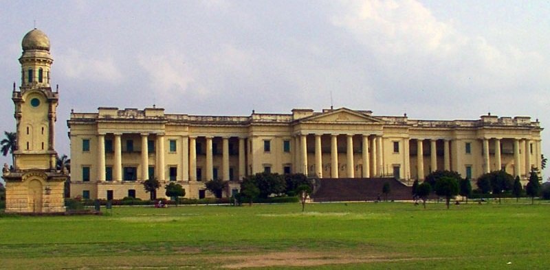
The coordinates of Murshidabad are 24.18°N 88.27°E. The main draw in Murshidabad is Hazarduari Palace and the surrounding locations in the Kila Nizamat neighborhood. The Motijhil neighborhood, Katra Masjid, Fauti Mosque, and Jama Masjid are all within a short distance away. The northern portion of the town is home to a number of attractions (as may be seen in the map alongside). On the other side of the river are a few attractions, including Khushbagh, Rosnaiganj, Baranagar, Kiriteswari Temple, Karnasuvarna, and others.
History
In ancient Bengal, the region was a part of both the Gauda and Vanga kingdoms. The town’s early growth was attributed by the Riyaz-us-Salatin to a trader by the name of Makhsus Khan. The Ain-i-Akbari also discusses the role of the merchant. The region gained notoriety for its sericulture in the seventeenth century. English spies reported in 1621 that there was a lot of silk available in the region. It was incorporated into the Mughal government in the 1660s and was given authority over European businesses in Cossimbazar.
Demography
There were 44,019 people living in Murshidabad as per the 2011 Indian Census, with 22,177 men and 21,842 women. There were 4,414 people in the 0 to 6 age group. In Murshidabad, there were 32,451 literate people, or 73.7% of the total population. Of these, 77.3% of men and 70.1% of women were literate. Murshidabad’s population aged 7 and over had an effective literacy rate of 81.9%, with 86.0% of men and 77.9% of women literate. There were 13,762 members of the Scheduled Castes and 302 members of the Scheduled Tribes. In 2011, there were 9829 homes in Murshidabad.
Climate
The climate in Murshidabad is tropical and semiarid. The monthly mean temperature ranges from 17 °C to 35 °C, with the yearly mean temperature being roughly 27 °C. During dry spells, the maximum temperatures frequently surpass 40 °C in May and June. Summers are hot and muggy, with lows in the low 30s. Winter typically lasts for just two and a half months, with December and January seeing the lowest seasonal lows of 9 to 11 degrees Celsius.
Economy
The majority of individuals rely on agriculture as their primary source of income. Although there are still some silk farms and weaving machinery in use, they are rapidly falling behind the contemporary industry. Murshidabad is renowned for producing high-quality silk. There is a beedi industry as well. This area is home to several of the largest beedi companies in India. The main trading and business partners are Burdwan, Kolkata, and Asansol. An internal water transport link between Dhulian and Rajshahi was discussed, but it hasn’t happened yet between India and Bangladesh.