Pincodes of Peren
Here is a list of Peren Pincodes
| No. | Location | Pincode | District | State |
|---|---|---|---|---|
| 1 | Athibung | 797110 | Peren | Nagaland |
| 2 | Bongkholong | 797110 | Peren | Nagaland |
| 3 | Gaili | 797110 | Peren | Nagaland |
| 4 | Jalukie 'b' | 797110 | Peren | Nagaland |
| 5 | Khelma | 797110 | Peren | Nagaland |
| 6 | Lilen | 797110 | Peren | Nagaland |
| 7 | Mbaulwa | 797101 | Peren | Nagaland |
| 8 | Mhainamtsi | 797110 | Peren | Nagaland |
| 9 | N.Song | 797101 | Peren | Nagaland |
| 10 | Nchongram | 797101 | Peren | Nagaland |
| 11 | New Jalukie | 797110 | Peren | Nagaland |
| 12 | Peren | 797101 | Peren | Nagaland |
| 13 | Samjiuram | 797110 | Peren | Nagaland |
| 14 | Tening | 797101 | Peren | Nagaland |
| 15 | Zalukie | 797110 | Peren | Nagaland |
About Peren
Peren District, nestled in Nagaland, India, emerged in 2003 following the division of Kohima District. Centered around the town of Peren, this district stands as a testament to growth and development. Its inception marked a new chapter, catering to the region’s specific needs and fostering community progress. The district’s formation in 2003 represents a strategic move, enabling more focused governance and attention to the unique cultural and developmental facets within this serene part of Nagaland. With Peren as its nucleus, the district embodies a hub for local governance and initiatives, uplifting the lives of its inhabitants through targeted interventions and provisions.
History
Peren district, once a subdivision of Kohima, gained its autonomy, emerging as an independent district on 24th October 2003. Evolving from its origins as part of Kohima, this transformation marked a pivotal moment in Peren’s history. The declaration of its separate district status signified a significant milestone, empowering the region with its own administrative identity. Since then, Peren has flourished independently, embracing its unique cultural heritage and contributing distinctively to the rich tapestry of Nagaland’s diverse districts.
Demography
In the 2011 census, Peren district reported a population of 95,219, akin to Seychelles’ populace. Positioned 616th among India’s 640 districts, Peren’s sex ratio stands at 917 females per 1000 males, while boasting a commendable literacy rate of 79%. This district in Nagaland embodies a demographic diversity mirroring global comparisons. Amidst its scenic landscapes and cultural richness, Peren’s statistics highlight progress in gender balance and education. Its population aligns with a small nation, reflecting a unique blend of heritage and contemporary growth. These figures underscore Peren’s evolving socio-cultural landscape, offering insights into its demographic fabric and developmental strides.
Geography
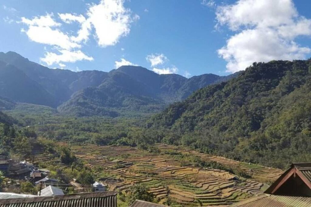
Peren District spans a mountainous terrain with fertile valleys in its northwest and northeast corners, forming the elongated southwestern tip of the state. It hosts key rivers like Tepuiki, Mbeiki (Barak), Ntanki, and others, enhancing its rich landscape. This district revels in a monsoon climate, thanks to its elevation and lush greenery, fostering a temperate, salubrious environment. Winters bring a cold yet pleasant vibe, while summers offer warmth without overwhelming heat. Peren’s geographic diversity, from peaks to plains, cultivates a unique climate, making it an ideal haven for those seeking a blend of natural beauty and comfortable weather.
Administration
Peren district delineates into three subdivisions—Jalukie, Peren, and Tening—each weaving a unique tapestry within Nagaland’s cultural landscape. Comprising seven vibrant blocks, the district showcases diversity through its circle blocks: Jalukie, Ngwalwa, Athibung, Peren, Tening, Kebai-Khelma, and Nsong. These subdivisions and blocks serve as the administrative hubs, fostering growth and development across the region. From the dynamic energy of Jalukie to the serene allure of Peren, and the cultural richness of Tening, each subdivision encapsulates distinct characteristics and contributes to the district’s multifaceted identity. Together, they embody the spirit of Peren, enriching the social and administrative fabric of this captivating district.