Pincodes of Sirohi
Sirohi Pincodes: Explore the diverse range of postal codes in Sirohi, a city teeming with cultural richness and historical significance. Unveil the convenience of locating areas with distinct pin codes facilitating easy navigation and parcel deliveries. From the bustling town center to the serene outskirts, discover the unique identity each pin code offers, aiding in precise addressing and efficient logistics. Unravel the mosaic of Sirohi’s landscape, from 307001 to 307026, each pin code encapsulates a specific region, reflecting the city’s vibrant tapestry. Experience seamless accessibility and accurate location references with Sirohi’s varied pin codes, making your local journeys hassle-free.
Here is a list of Sirohi Pincodes
| No. | Location | Pincode | District | State |
|---|---|---|---|---|
| 1 | A.I.a. aburoad | 307026 | Sirohi | Rajasthan |
| 2 | Abu | 307501 | Sirohi | Rajasthan |
| 3 | Aburoad | 307026 | Sirohi | Rajasthan |
| 4 | Aburoad Bazar | 307026 | Sirohi | Rajasthan |
| 5 | Aburoad Disel shed | 307026 | Sirohi | Rajasthan |
| 6 | Aburoad Gandhi nagar | 307026 | Sirohi | Rajasthan |
| 7 | Achpura | 307510 | Sirohi | Rajasthan |
| 8 | Ajari | 307022 | Sirohi | Rajasthan |
| 9 | Akrabhatta | 307510 | Sirohi | Rajasthan |
| 10 | Alpa | 307028 | Sirohi | Rajasthan |
| 11 | Amlari | 307512 | Sirohi | Rajasthan |
| 12 | Amli | 307025 | Sirohi | Rajasthan |
| 13 | Amthala | 307510 | Sirohi | Rajasthan |
| 14 | Anadra | 307511 | Sirohi | Rajasthan |
| 15 | Andore | 307043 | Sirohi | Rajasthan |
| 16 | Arathwara | 307028 | Sirohi | Rajasthan |
| 17 | Awal | 307026 | Sirohi | Rajasthan |
| 18 | Badgaon | 307027 | Sirohi | Rajasthan |
| 19 | Bagseen | 307043 | Sirohi | Rajasthan |
| 20 | Bahadurpura | 307026 | Sirohi | Rajasthan |
| 21 | Balda | 307001 | Sirohi | Rajasthan |
| 22 | Bant | 307513 | Sirohi | Rajasthan |
| 23 | Barloot | 307801 | Sirohi | Rajasthan |
| 24 | Basan | 307514 | Sirohi | Rajasthan |
| 25 | Basantgarh | 307019 | Sirohi | Rajasthan |
| 26 | Bharja | 307026 | Sirohi | Rajasthan |
| 27 | Bhatana | 307514 | Sirohi | Rajasthan |
| 28 | Bhawari | 307023 | Sirohi | Rajasthan |
| 29 | Bherugarh | 307514 | Sirohi | Rajasthan |
| 30 | Bhev | 307028 | Sirohi | Rajasthan |
| 31 | Bhimana R.s. | 307024 | Sirohi | Rajasthan |
| 32 | Bhula | 307024 | Sirohi | Rajasthan |
| 33 | Bhutgaon | 307801 | Sirohi | Rajasthan |
| 34 | Binanigram | 307025 | Sirohi | Rajasthan |
| 35 | Chadual | 307802 | Sirohi | Rajasthan |
| 36 | Chandela | 307026 | Sirohi | Rajasthan |
| 37 | Chandrawati | 307026 | Sirohi | Rajasthan |
| 38 | Channar | 307026 | Sirohi | Rajasthan |
| 39 | Chhibagaon | 307043 | Sirohi | Rajasthan |
| 40 | Chuli | 307028 | Sirohi | Rajasthan |
| 41 | Dabani | 307511 | Sirohi | Rajasthan |
| 42 | Dak | 307511 | Sirohi | Rajasthan |
| 43 | Dantrai | 307512 | Sirohi | Rajasthan |
| 44 | Dattani | 307026 | Sirohi | Rajasthan |
| 45 | Deldar | 307026 | Sirohi | Rajasthan |
| 46 | Deldear | 307801 | Sirohi | Rajasthan |
| 47 | Delwara | 307501 | Sirohi | Rajasthan |
| 48 | Derri | 307026 | Sirohi | Rajasthan |
| 49 | Dhan | 307512 | Sirohi | Rajasthan |
| 50 | Dhanari | 307023 | Sirohi | Rajasthan |
| 51 | Dhanta | 307001 | Sirohi | Rajasthan |
| 52 | Dhavli | 307026 | Sirohi | Rajasthan |
| 53 | Dhurbana | 307027 | Sirohi | Rajasthan |
| 54 | Dodua | 307001 | Sirohi | Rajasthan |
| 55 | Doytra | 307024 | Sirohi | Rajasthan |
| 56 | Ganka | 307510 | Sirohi | Rajasthan |
| 57 | Girwar | 307026 | Sirohi | Rajasthan |
| 58 | Gohili | 307001 | Sirohi | Rajasthan |
| 59 | Gol | 307801 | Sirohi | Rajasthan |
| 60 | Gulabganj | 307511 | Sirohi | Rajasthan |
| 61 | Haliwara | 307802 | Sirohi | Rajasthan |
| 62 | Hathal | 307511 | Sirohi | Rajasthan |
| 63 | Ishra | 307023 | Sirohi | Rajasthan |
| 64 | Jamburi | 307026 | Sirohi | Rajasthan |
| 65 | Janapur | 307022 | Sirohi | Rajasthan |
| 66 | Jawal | 307801 | Sirohi | Rajasthan |
| 67 | Jayadara | 307026 | Sirohi | Rajasthan |
| 68 | Jeerwal | 307514 | Sirohi | Rajasthan |
| 69 | Jela | 307802 | Sirohi | Rajasthan |
| 70 | Jetawara | 307513 | Sirohi | Rajasthan |
| 71 | Jetpura | 307027 | Sirohi | Rajasthan |
| 72 | Jhadoli | 307022 | Sirohi | Rajasthan |
| 73 | Jhadoliveer | 307801 | Sirohi | Rajasthan |
| 74 | Jkpuram | 307019 | Sirohi | Rajasthan |
| 75 | Jogapura | 307028 | Sirohi | Rajasthan |
| 76 | Jolapur | 307514 | Sirohi | Rajasthan |
| 77 | Joyla | 307028 | Sirohi | Rajasthan |
| 78 | Kachholi | 307023 | Sirohi | Rajasthan |
| 79 | Kalandari | 307802 | Sirohi | Rajasthan |
| 80 | Kermandwara | 307023 | Sirohi | Rajasthan |
| 81 | Kesharpura | 307027 | Sirohi | Rajasthan |
| 82 | Khadat | 307026 | Sirohi | Rajasthan |
| 83 | Khambal | 307001 | Sirohi | Rajasthan |
| 84 | Khandera | 307028 | Sirohi | Rajasthan |
| 85 | Kiverli | 307510 | Sirohi | Rajasthan |
| 86 | Kojra | 307022 | Sirohi | Rajasthan |
| 87 | Krishnaganj | 307001 | Sirohi | Rajasthan |
| 88 | Kyariya | 307026 | Sirohi | Rajasthan |
| 89 | Lass | 307801 | Sirohi | Rajasthan |
| 90 | Lunol | 307514 | Sirohi | Rajasthan |
| 91 | Madia | 307802 | Sirohi | Rajasthan |
| 92 | Magriwara | 307514 | Sirohi | Rajasthan |
| 93 | Makawal | 307026 | Sirohi | Rajasthan |
| 94 | Makroda | 307001 | Sirohi | Rajasthan |
| 95 | Malgaon | 307511 | Sirohi | Rajasthan |
| 96 | Mamawali | 307001 | Sirohi | Rajasthan |
| 97 | Manadar | 307801 | Sirohi | Rajasthan |
| 98 | Mandani | 307801 | Sirohi | Rajasthan |
| 99 | Mandar | 307513 | Sirohi | Rajasthan |
| 100 | Mandwa | 307001 | Sirohi | Rajasthan |
| 101 | Mandwara | 307801 | Sirohi | Rajasthan |
| 102 | Mandwarakhalsa | 307023 | Sirohi | Rajasthan |
| 103 | Mandwaria | 307801 | Sirohi | Rajasthan |
| 104 | Manora | 307801 | Sirohi | Rajasthan |
| 105 | Marol | 307514 | Sirohi | Rajasthan |
| 106 | Mawal | 307026 | Sirohi | Rajasthan |
| 107 | Mermandwara | 307802 | Sirohi | Rajasthan |
| 108 | Mohabbatnagar | 307802 | Sirohi | Rajasthan |
| 109 | Moras | 307022 | Sirohi | Rajasthan |
| 110 | Morli | 307043 | Sirohi | Rajasthan |
| 111 | Morthala | 307026 | Sirohi | Rajasthan |
| 112 | Muderla | 307510 | Sirohi | Rajasthan |
| 113 | Mungthala | 307026 | Sirohi | Rajasthan |
| 114 | Nagani | 307511 | Sirohi | Rajasthan |
| 115 | Nandia | 307022 | Sirohi | Rajasthan |
| 116 | Naradara | 307801 | Sirohi | Rajasthan |
| 117 | Nawara | 307802 | Sirohi | Rajasthan |
| 118 | Nichalagarh | 307026 | Sirohi | Rajasthan |
| 119 | Nimbaj | 307512 | Sirohi | Rajasthan |
| 120 | Nitora | 307023 | Sirohi | Rajasthan |
| 121 | Oda | 307801 | Sirohi | Rajasthan |
| 122 | Ore | 307026 | Sirohi | Rajasthan |
| 123 | Oriya | 307501 | Sirohi | Rajasthan |
| 124 | Paba | 307024 | Sirohi | Rajasthan |
| 125 | Padar | 307514 | Sirohi | Rajasthan |
| 126 | Padiv | 307001 | Sirohi | Rajasthan |
| 127 | Palri M | 307043 | Sirohi | Rajasthan |
| 128 | Pamera | 307511 | Sirohi | Rajasthan |
| 129 | Pehsua | 307022 | Sirohi | Rajasthan |
| 130 | Phungani | 307802 | Sirohi | Rajasthan |
| 131 | Pindwara | 307022 | Sirohi | Rajasthan |
| 132 | Pithapura | 307513 | Sirohi | Rajasthan |
| 133 | Posalia | 307028 | Sirohi | Rajasthan |
| 134 | Positra | 307511 | Sirohi | Rajasthan |
| 135 | Raipur | 307513 | Sirohi | Rajasthan |
| 136 | Rampura | 307001 | Sirohi | Rajasthan |
| 137 | Reodar | 307514 | Sirohi | Rajasthan |
| 138 | Rohida | 307024 | Sirohi | Rajasthan |
| 139 | Rowada | 307028 | Sirohi | Rajasthan |
| 140 | Sangana | 307026 | Sirohi | Rajasthan |
| 141 | Sanpur | 307512 | Sirohi | Rajasthan |
| 142 | Santpur | 307026 | Sirohi | Rajasthan |
| 143 | Sanwara | 307511 | Sirohi | Rajasthan |
| 144 | Sartara | 307802 | Sirohi | Rajasthan |
| 145 | Sarupganj | 307023 | Sirohi | Rajasthan |
| 146 | Shantivan | 307510 | Sirohi | Rajasthan |
| 147 | Sheoganj | 307027 | Sirohi | Rajasthan |
| 148 | Sheoganj Subji mandi | 307027 | Sirohi | Rajasthan |
| 149 | Sildar | 307802 | Sirohi | Rajasthan |
| 150 | Sindrath | 307001 | Sirohi | Rajasthan |
| 151 | Sirodi | 307511 | Sirohi | Rajasthan |
| 152 | Sirohi | 307001 | Sirohi | Rajasthan |
| 153 | Sirohi Bazar | 307001 | Sirohi | Rajasthan |
| 154 | Sirohi Bhatkra | 307001 | Sirohi | Rajasthan |
| 155 | Sirohi Road | 307021 | Sirohi | Rajasthan |
| 156 | Sirohi Sarupvilas | 307001 | Sirohi | Rajasthan |
| 157 | Sivera | 307022 | Sirohi | Rajasthan |
| 158 | Siyawa | 307026 | Sirohi | Rajasthan |
| 159 | Soorpagla | 307026 | Sirohi | Rajasthan |
| 160 | Sorda | 307513 | Sirohi | Rajasthan |
| 161 | Tankiya | 307026 | Sirohi | Rajasthan |
| 162 | Tanwari | 307802 | Sirohi | Rajasthan |
| 163 | Tartoli | 307026 | Sirohi | Rajasthan |
| 164 | Telpur | 307022 | Sirohi | Rajasthan |
| 165 | Udd | 307801 | Sirohi | Rajasthan |
| 166 | Udwaria | 307511 | Sirohi | Rajasthan |
| 167 | Uplagarh | 307026 | Sirohi | Rajasthan |
| 168 | Uthman | 307043 | Sirohi | Rajasthan |
| 169 | Utraj | 307501 | Sirohi | Rajasthan |
| 170 | Valdra | 307001 | Sirohi | Rajasthan |
| 171 | Valoriya | 307024 | Sirohi | Rajasthan |
| 172 | Van | 307043 | Sirohi | Rajasthan |
| 173 | Varada | 307801 | Sirohi | Rajasthan |
| 174 | Varli | 307022 | Sirohi | Rajasthan |
| 175 | Varman | 307514 | Sirohi | Rajasthan |
| 176 | Vasa | 307024 | Sirohi | Rajasthan |
| 177 | Vasda | 307026 | Sirohi | Rajasthan |
| 178 | Vatera | 307024 | Sirohi | Rajasthan |
| 179 | Vellangari | 307001 | Sirohi | Rajasthan |
| 180 | Verwara | 307022 | Sirohi | Rajasthan |
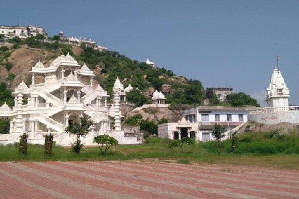
About Sirohi
Nestled in southern Rajasthan, Sirohi city serves as the administrative hub of Sirohi District. Once the princely state’s capital, it was under the reign of the Deora Chauhan Rajput rulers. The city boasts the accolade of securing the top spot in Rajasthan’s 33 districts for the “Swachha Bharat Abhiyaan” in 2014. Accessible through the nearby Sirohi Road railway station, this city embodies a blend of heritage and modernity. Its rich history, coupled with commendable cleanliness initiatives, marks Sirohi as a beacon of cultural legacy and progressive initiatives in western India’s scenic landscape.
History
In 1405, Rao Sobhaji established Shivpuri on Siranwa Hill’s eastern incline. However, Shivpuri now remains a relic. By 1425, Sobhaji’s heir, Sehastramal (or Sainsmal), erected a fortress on the hill’s same eastern slope. This stronghold evolved into Sirohi’s current town and served as his capital, marking the genesis of present-day Sirohi.
FAQs
What is Sirohi famous for?
Sirohi, known as "Dev Nagari," boasts numerous ancient temples. Renowned for crafting double-edged swords since the Chauhan Deora reign till 1947.
What is the population of Sirohi district?
Sirohi, known as "Dev Nagari," boasts numerous ancient temples. Renowned for crafting double-edged swords since the Chauhan Deora reign till 1947.
Which temple is famous in Sirohi Rajasthan?
Sarneshwar temple, honoring Lord Shiv, rests on Siranwa hill's western slope. A revered site for the Deora Clan of Chauhans in Sirohi, potentially crafted during Parmar Dynasty's reign.
What is the religion of Sirohi?
As per the official 2011 census and updated 2023 population data, Hindus form the predominant majority in Sirohi, comprising 96.16% of the district's 1,036,346 population.
What are the tribes in Sirohi?
The region hosts diverse ethnicities like Bhil, Damor, Damriya, Kathodi, and more. Among them, the Garasia predominantly reside within the forests here.