Pincodes of Theni
Theni Pincodes cover a range of locations within the quaint district of Theni, Tamil Nadu, India. Theni, well-known for its scenic surroundings, agricultural importance, and rich cultural legacy, presents a lovely fusion of rustic charm and history. Discover pure rivers, verdant hills, and ancient temples situated amidst stunning scenery. Access to the center of this area, where farming, spirituality, and the peaceful natural surroundings coexist peacefully, is made possible by Theni Pincodes. These pincodes offer an insightful journey into the heart of Theni’s rustic beauty, whether you’re trekking in the Western Ghats, touring historic shrines, or taking in the local way of life.
Here is a list of Theni Pincodes
| No. | Location | Pincode | District | State |
|---|---|---|---|---|
| 1 | A.Vadipatti | 625602 | Theni | Tamil Nadu |
| 2 | Agamalai | 625605 | Theni | Tamil Nadu |
| 3 | Alagapuri | 625523 | Theni | Tamil Nadu |
| 4 | Allinagaram | 625531 | Theni | Tamil Nadu |
| 5 | Ammapatti | 625512 | Theni | Tamil Nadu |
| 6 | Ammatchiapuram | 625531 | Theni | Tamil Nadu |
| 7 | Anaikaraipatti | 625582 | Theni | Tamil Nadu |
| 8 | Anamalayanpatti | 625526 | Theni | Tamil Nadu |
| 9 | Annanji | 625531 | Theni | Tamil Nadu |
| 10 | Appipatti | 625515 | Theni | Tamil Nadu |
| 11 | Athankaraipatti | 625517 | Theni | Tamil Nadu |
| 12 | Aundipatti | 625512 | Theni | Tamil Nadu |
| 13 | B.Ammapatti | 625528 | Theni | Tamil Nadu |
| 14 | B.Meenakshipuram | 625582 | Theni | Tamil Nadu |
| 15 | Bangalamedu | 625531 | Theni | Tamil Nadu |
| 16 | Bodidasanpatti | 625536 | Theni | Tamil Nadu |
| 17 | Bodimettu | 625582 | Theni | Tamil Nadu |
| 18 | Bodinayakanur | 625513 | Theni | Tamil Nadu |
| 19 | Bodinayakanur Bazar | 625513 | Theni | Tamil Nadu |
| 20 | Bodinayakanur North | 625513 | Theni | Tamil Nadu |
| 21 | Bodinayakanur R.s. | 625513 | Theni | Tamil Nadu |
| 22 | Bomminayakanpatti | 625602 | Theni | Tamil Nadu |
| 23 | Buthipuram | 625531 | Theni | Tamil Nadu |
| 24 | C.Pudupatti | 625556 | Theni | Tamil Nadu |
| 25 | Central Station | 625582 | Theni | Tamil Nadu |
| 26 | Chinnakattalai | 625527 | Theni | Tamil Nadu |
| 27 | Chinnamanur | 625515 | Theni | Tamil Nadu |
| 28 | Chinnamanur Bazar | 625515 | Theni | Tamil Nadu |
| 29 | Chinnaovalapuram | 625515 | Theni | Tamil Nadu |
| 30 | Cumbum | 625516 | Theni | Tamil Nadu |
| 31 | Cumbum West | 625516 | Theni | Tamil Nadu |
| 32 | Devadanapatti | 625602 | Theni | Tamil Nadu |
| 33 | Dharmapuri | 625520 | Theni | Tamil Nadu |
| 34 | Endapuli | 625604 | Theni | Tamil Nadu |
| 35 | Erasakkanayakanur | 625515 | Theni | Tamil Nadu |
| 36 | Erumalainayakanpatti | 625602 | Theni | Tamil Nadu |
| 37 | Ethakovil | 625536 | Theni | Tamil Nadu |
| 38 | G.Kallupatti | 625203 | Theni | Tamil Nadu |
| 39 | G.Usilampatti | 625517 | Theni | Tamil Nadu |
| 40 | Gandamanayakanur | 625517 | Theni | Tamil Nadu |
| 41 | Gandhinagar (cumbum) | 625516 | Theni | Tamil Nadu |
| 42 | Genguvarpatti | 625203 | Theni | Tamil Nadu |
| 43 | Gokilapuram | 625526 | Theni | Tamil Nadu |
| 44 | Gopalapuram | 625534 | Theni | Tamil Nadu |
| 45 | Govindagaram | 625517 | Theni | Tamil Nadu |
| 46 | Gudalur | 625518 | Theni | Tamil Nadu |
| 47 | Gullapuram | 625562 | Theni | Tamil Nadu |
| 48 | Hanumanthanpatti | 625533 | Theni | Tamil Nadu |
| 49 | Highwavys | 625519 | Theni | Tamil Nadu |
| 50 | Jangalpatti | 625520 | Theni | Tamil Nadu |
| 51 | Jeevanagar | 625513 | Theni | Tamil Nadu |
| 52 | Jeyamangalam | 625603 | Theni | Tamil Nadu |
| 53 | Kadamalaikundu | 625579 | Theni | Tamil Nadu |
| 54 | Kamarajapuram | 625582 | Theni | Tamil Nadu |
| 55 | Kamatchipuram | 625520 | Theni | Tamil Nadu |
| 56 | Kamayakoundanpatti | 625521 | Theni | Tamil Nadu |
| 57 | Kanniappapillaipatti | 625512 | Theni | Tamil Nadu |
| 58 | Kanniservaipatti | 625515 | Theni | Tamil Nadu |
| 59 | Karunagamuthanpatti | 625516 | Theni | Tamil Nadu |
| 60 | Keelagudalur | 625518 | Theni | Tamil Nadu |
| 61 | Kodangipatti | 625547 | Theni | Tamil Nadu |
| 62 | Koduvilarpatti | 625534 | Theni | Tamil Nadu |
| 63 | Koilpatti | 625562 | Theni | Tamil Nadu |
| 64 | Kombai | 625522 | Theni | Tamil Nadu |
| 65 | Kombaitholu | 625579 | Theni | Tamil Nadu |
| 66 | Koolayanur | 625515 | Theni | Tamil Nadu |
| 67 | Kothaloothu | 625512 | Theni | Tamil Nadu |
| 68 | Kothapatti | 625512 | Theni | Tamil Nadu |
| 69 | Kottagudi | 625582 | Theni | Tamil Nadu |
| 70 | Kottur | 625534 | Theni | Tamil Nadu |
| 71 | Kovilparai | 625579 | Theni | Tamil Nadu |
| 72 | Krishnampatti | 625530 | Theni | Tamil Nadu |
| 73 | Kujjanur | 625515 | Theni | Tamil Nadu |
| 74 | Kullappagoundanpatti | 625516 | Theni | Tamil Nadu |
| 75 | Kumizhantholu | 625579 | Theni | Tamil Nadu |
| 76 | Kunnur | 625531 | Theni | Tamil Nadu |
| 77 | Kuppinayakanpatti | 625520 | Theni | Tamil Nadu |
| 78 | Kurangani | 625582 | Theni | Tamil Nadu |
| 79 | Lakshminayakanpatti | 625530 | Theni | Tamil Nadu |
| 80 | Lakshmipuram | 625523 | Theni | Tamil Nadu |
| 81 | Manalar | 625519 | Theni | Tamil Nadu |
| 82 | Manjalar Dam | 625602 | Theni | Tamil Nadu |
| 83 | Marikundu | 625517 | Theni | Tamil Nadu |
| 84 | Markeyankottai | 625552 | Theni | Tamil Nadu |
| 85 | Mayiladumparai | 625579 | Theni | Tamil Nadu |
| 86 | Megamalai | 625515 | Theni | Tamil Nadu |
| 87 | Melachokkanathapuram | 625582 | Theni | Tamil Nadu |
| 88 | Melasindalachery | 625524 | Theni | Tamil Nadu |
| 89 | Melmangalam | 625603 | Theni | Tamil Nadu |
| 90 | Moolakadai | 625579 | Theni | Tamil Nadu |
| 91 | Mottanuthu | 625512 | Theni | Tamil Nadu |
| 92 | Murugamalainagar | 625605 | Theni | Tamil Nadu |
| 93 | Muthulapuram | 625515 | Theni | Tamil Nadu |
| 94 | Nagalapuram | 625528 | Theni | Tamil Nadu |
| 95 | Nallakaruppanpatti | 625604 | Theni | Tamil Nadu |
| 96 | Narayanathevanpatti | 625521 | Theni | Tamil Nadu |
| 97 | Odaipatti | 625540 | Theni | Tamil Nadu |
| 98 | Okkaraipatti | 625517 | Theni | Tamil Nadu |
| 99 | P.Dharmathupatti | 625536 | Theni | Tamil Nadu |
| 100 | Palacombai | 625512 | Theni | Tamil Nadu |
| 101 | Palanichettipatti | 625531 | Theni | Tamil Nadu |
| 102 | Pallavarayanpatti | 625524 | Theni | Tamil Nadu |
| 103 | Pannaipuram | 625524 | Theni | Tamil Nadu |
| 104 | Periyakulam | 625601 | Theni | Tamil Nadu |
| 105 | Periyakulam Bazaar | 625601 | Theni | Tamil Nadu |
| 106 | Periyakulam East | 625604 | Theni | Tamil Nadu |
| 107 | Periyakulam Public office | 625601 | Theni | Tamil Nadu |
| 108 | Periyar Project | 625525 | Theni | Tamil Nadu |
| 109 | Poomalaikundu | 625520 | Theni | Tamil Nadu |
| 110 | Poosanuthu | 625579 | Theni | Tamil Nadu |
| 111 | Pottipuram | 625528 | Theni | Tamil Nadu |
| 112 | Pulikuthi | 625524 | Theni | Tamil Nadu |
| 113 | Pullimankombai | 625536 | Theni | Tamil Nadu |
| 114 | Rajadhani | 625512 | Theni | Tamil Nadu |
| 115 | Rajagopalanpatti | 625536 | Theni | Tamil Nadu |
| 116 | Rasingapuram | 625528 | Theni | Tamil Nadu |
| 117 | Rengasamudram | 625562 | Theni | Tamil Nadu |
| 118 | Rosanampatti | 625512 | Theni | Tamil Nadu |
| 119 | Royappanpatti | 625526 | Theni | Tamil Nadu |
| 120 | Sankarapuram | 625530 | Theni | Tamil Nadu |
| 121 | Saruthupatti | 625523 | Theni | Tamil Nadu |
| 122 | Sathakoilpatti | 625602 | Theni | Tamil Nadu |
| 123 | Seelayampatti | 625515 | Theni | Tamil Nadu |
| 124 | Seepalakottai | 625540 | Theni | Tamil Nadu |
| 125 | Shunmugasundarapuram | 625512 | Theni | Tamil Nadu |
| 126 | Silamalai | 625528 | Theni | Tamil Nadu |
| 127 | Sillamarathupatti | 625528 | Theni | Tamil Nadu |
| 128 | Silvarpatti | 625602 | Theni | Tamil Nadu |
| 129 | Sindalacherry | 625530 | Theni | Tamil Nadu |
| 130 | Siraparai | 625579 | Theni | Tamil Nadu |
| 131 | Srirengapuram | 625534 | Theni | Tamil Nadu |
| 132 | Subburajnagar | 625582 | Theni | Tamil Nadu |
| 133 | Sukkangalpatti | 625540 | Theni | Tamil Nadu |
| 134 | Surulipatti | 625516 | Theni | Tamil Nadu |
| 135 | Suruliyar Lower camp | 625525 | Theni | Tamil Nadu |
| 136 | T.Kallipatti | 625605 | Theni | Tamil Nadu |
| 137 | T.Meenatchipuram | 625530 | Theni | Tamil Nadu |
| 138 | T.Nagar (theni) | 625531 | Theni | Tamil Nadu |
| 139 | T.Subbulapuram | 625536 | Theni | Tamil Nadu |
| 140 | T.V.renganathapuram | 625536 | Theni | Tamil Nadu |
| 141 | Tadichery | 625534 | Theni | Tamil Nadu |
| 142 | Tamarakulam | 625605 | Theni | Tamil Nadu |
| 143 | Thamminayakanpatti | 625530 | Theni | Tamil Nadu |
| 144 | Thangammalpuram | 625579 | Theni | Tamil Nadu |
| 145 | Thekkampatti | 625517 | Theni | Tamil Nadu |
| 146 | Theni | 625531 | Theni | Tamil Nadu |
| 147 | Theni East | 625531 | Theni | Tamil Nadu |
| 148 | Theppampatti | 625512 | Theni | Tamil Nadu |
| 149 | Thevaram | 625530 | Theni | Tamil Nadu |
| 150 | Thimmarasanayakanur | 625536 | Theni | Tamil Nadu |
| 151 | Thullukuttinayakanur | 625705 | Theni | Tamil Nadu |
| 152 | Thummagundu | 625579 | Theni | Tamil Nadu |
| 153 | U.Ammapatti | 625533 | Theni | Tamil Nadu |
| 154 | Upparpatti | 625534 | Theni | Tamil Nadu |
| 155 | Uppukottai | 625534 | Theni | Tamil Nadu |
| 156 | Uthamapalayam | 625533 | Theni | Tamil Nadu |
| 157 | Uthamapalayam Bazar | 625533 | Theni | Tamil Nadu |
| 158 | Uthamapalayam West | 625533 | Theni | Tamil Nadu |
| 159 | Vadagarai | 625601 | Theni | Tamil Nadu |
| 160 | Vadugapatti | 625603 | Theni | Tamil Nadu |
| 161 | Vaigaidamsite | 625562 | Theni | Tamil Nadu |
| 162 | Vaigaiproject | 625562 | Theni | Tamil Nadu |
| 163 | Varadharajnagar | 625562 | Theni | Tamil Nadu |
| 164 | Varushanadu | 625579 | Theni | Tamil Nadu |
| 165 | Veerapandi | 625534 | Theni | Tamil Nadu |
| 166 | Vellaiyammalpuram | 625540 | Theni | Tamil Nadu |
| 167 | Venkatachalapuram | 625572 | Theni | Tamil Nadu |
| 168 | Venniar Estate | 625538 | Theni | Tamil Nadu |
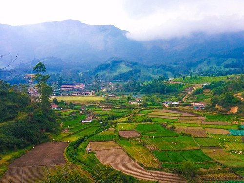
About Theni
There are 38 districts in the Indian state of Tamil Nadu, including Theni District. The area is next to the Madurai district and is well-protected by the picturesque hill locks. The district office is located in the town of Theni. The district is naturally divided into two sections: the hilly areas, which include parts of Theni, Bodinayakanur, Periyakulam, Uthamapalayam, and Andipatti taluks, and the Cumbum valley, which is located in Uthamapalayam taluk. The hilly areas are characterized by dense vegetation and perennial streams that emerge from the hills on the western side.
History
According to G.O. Ms. No. 679 Revenue Department dated July 7, 1996, the former Madurai District was divided to form the Theni District. Following the split, two new Taluks Theni and Bodinayakanur and a new Revenue Division with its headquarters located in Uthamapalayam were established, effective January 1, 1997. Up until December 31, 1996, Theni Municipal Town served only as the headquarters of Firka. On January 1, 1997, Theni Municipal Town became the Taluk and District headquarters following the creation of the new District.
Geography
At the base of the Western Ghats, the 2,889 km2 (1,115 sq mi) district is located between 9′ 39′ and 10′ 30′ North latitude and between 77′ 00′ and 78′ 30′ East longitude. Location center: 10°04′N 77°45′E. The district is bordered to the north by the Dindigul District, to the east by the Madurai District, to the southwest by the Virudhunagar District, and to the west by the Idukki district of Kerala State.
Climate
The plains see minimum temperatures of 15 °C (59 °F) and highest temperatures of 40 °C (104 °F). Temperatures in the hills can vary from 4-5 °C (39–41 °F) to 25 °C (77 °F). The region is renowned for its lakes, hills, and pleasant weather.
Economy
Theni district’s economy is primarily based on agriculture. The district’s land area utilised for agriculture is 40.33%. Sugarcane (1,201,221), cotton 95,360 (561 bales of 170 kg lint each), rice (paddy) 66,093, millets and other cereals 57,081, pulses 6,677, groundnut 4,021 and gingelly 325 were the main crops produced (in tonnes) in 2005–2006. Other major produce of the district includes silk, bananas, coconuts, tea, coffee, cardamom, grapes, and mangoes. despite the fact that this area has a strong economy. The world’s highest tea plantation is in Kolukkumalai, which is situated in the Theni district at the summit of the Western Ghats.
Demography
53.81% of the 1,245,899 people living in the Theni district were urban dwellers, and the district had a sex ratio of 991 females for every 1,000 males, which was much higher than the 929 national average. There were 59,661 children under the age of six in all, made up of 57,788 girls and 61,873 boys. Scheduled Tribes made up 0.15% and 20.72% of the population, respectively, of Scheduled Castes. The district’s average literacy rate was 69.84%, while the national average was 72.99%. In all, there were 338,112 households in the district.