Pincodes of Thoubal
Here is a list of Thoubal Pincodes
| No. | Location | Pincode | District | State |
|---|---|---|---|---|
| 1 | Aimol Kodamphai | 795135 | Thoubal | Manipur |
| 2 | Andro | 795149 | Thoubal | Manipur |
| 3 | Angbrashu | 795135 | Thoubal | Manipur |
| 4 | Angtha | 795149 | Thoubal | Manipur |
| 5 | Arapyi | 795130 | Thoubal | Manipur |
| 6 | Arong Nongmaikhong | 795103 | Thoubal | Manipur |
| 7 | Athokpam | 795138 | Thoubal | Manipur |
| 8 | Athokpam Khunou | 795138 | Thoubal | Manipur |
| 9 | Bongbal Khullen | 795149 | Thoubal | Manipur |
| 10 | Bongli | 795135 | Thoubal | Manipur |
| 11 | Chairen | 795101 | Thoubal | Manipur |
| 12 | Chajing Pt ii | 795130 | Thoubal | Manipur |
| 13 | Changamdabi | 795149 | Thoubal | Manipur |
| 14 | Charangpat | 795138 | Thoubal | Manipur |
| 15 | Chaton | 795135 | Thoubal | Manipur |
| 16 | Chelhep | 795135 | Thoubal | Manipur |
| 17 | Cherapur | 795148 | Thoubal | Manipur |
| 18 | Elangkhangpokpi | 795103 | Thoubal | Manipur |
| 19 | Haokha | 795138 | Thoubal | Manipur |
| 20 | Haokhongching | 795149 | Thoubal | Manipur |
| 21 | Haoreibi Mayai leikai | 795130 | Thoubal | Manipur |
| 22 | Heinganglok | 795149 | Thoubal | Manipur |
| 23 | Heinoumakhong | 795130 | Thoubal | Manipur |
| 24 | Heirok Part 2 | 795148 | Thoubal | Manipur |
| 25 | Herok Part 1 | 795148 | Thoubal | Manipur |
| 26 | Hivanalam | 795103 | Thoubal | Manipur |
| 27 | Hulkap | 795149 | Thoubal | Manipur |
| 28 | Irong Tangkhul | 795149 | Thoubal | Manipur |
| 29 | Irong Thokchom (t/c/d) | 795138 | Thoubal | Manipur |
| 30 | Jul Bangching | 795101 | Thoubal | Manipur |
| 31 | K M college | 795103 | Thoubal | Manipur |
| 32 | K. molnam | 795101 | Thoubal | Manipur |
| 33 | Kakching | 795103 | Thoubal | Manipur |
| 34 | Kakching Khunou | 795103 | Thoubal | Manipur |
| 35 | Kalikalok | 795103 | Thoubal | Manipur |
| 36 | Kambang Khunou | 795135 | Thoubal | Manipur |
| 37 | Kamu Tampak | 795149 | Thoubal | Manipur |
| 38 | Kamu Tongam | 795149 | Thoubal | Manipur |
| 39 | Kamuching | 795149 | Thoubal | Manipur |
| 40 | Karongthel | 795148 | Thoubal | Manipur |
| 41 | Kasom Khullen | 795149 | Thoubal | Manipur |
| 42 | Keibung Mamang | 795138 | Thoubal | Manipur |
| 43 | Keirak | 795103 | Thoubal | Manipur |
| 44 | Khambathel | 795101 | Thoubal | Manipur |
| 45 | Khangabok | 795138 | Thoubal | Manipur |
| 46 | Khangbaram | 795135 | Thoubal | Manipur |
| 47 | Kharou Khullen | 795135 | Thoubal | Manipur |
| 48 | Khekmanedbo | 795138 | Thoubal | Manipur |
| 49 | Khoibu | 795135 | Thoubal | Manipur |
| 50 | Khoirom | 795149 | Thoubal | Manipur |
| 51 | Khongjom | 795148 | Thoubal | Manipur |
| 52 | Khonglou Vaiphei (t/c/d) | 795149 | Thoubal | Manipur |
| 53 | Khongnangpheisani | 795101 | Thoubal | Manipur |
| 54 | Khousat (t/c/d) | 795135 | Thoubal | Manipur |
| 55 | Khudei Khunou | 795103 | Thoubal | Manipur |
| 56 | Khunbi | 795135 | Thoubal | Manipur |
| 57 | Kiyam Shiphai | 795138 | Thoubal | Manipur |
| 58 | Kshetri Leikai | 795138 | Thoubal | Manipur |
| 59 | Laiching Khongsang | 795135 | Thoubal | Manipur |
| 60 | Lairabokhong | 795130 | Thoubal | Manipur |
| 61 | Lamkang Khunou | 795135 | Thoubal | Manipur |
| 62 | Lamlong Khullen | 795135 | Thoubal | Manipur |
| 63 | Lamlong Khunou | 795135 | Thoubal | Manipur |
| 64 | Langmeidon | 795103 | Thoubal | Manipur |
| 65 | Leibi | 795135 | Thoubal | Manipur |
| 66 | Leingangching | 795103 | Thoubal | Manipur |
| 67 | Lembakhul | 795138 | Thoubal | Manipur |
| 68 | Lilong | 795130 | Thoubal | Manipur |
| 69 | Liwachangning | 795135 | Thoubal | Manipur |
| 70 | Longja | 795101 | Thoubal | Manipur |
| 71 | Louremba | 795149 | Thoubal | Manipur |
| 72 | Lungthar | 795149 | Thoubal | Manipur |
| 73 | M Bongmol | 795101 | Thoubal | Manipur |
| 74 | Machi | 795135 | Thoubal | Manipur |
| 75 | Mahou Tera | 795101 | Thoubal | Manipur |
| 76 | Mairembam | 795103 | Thoubal | Manipur |
| 77 | Mantak | 795103 | Thoubal | Manipur |
| 78 | Mayang Imphal | 795132 | Thoubal | Manipur |
| 79 | Minou Khunjao | 795135 | Thoubal | Manipur |
| 80 | Moijing | 795138 | Thoubal | Manipur |
| 81 | Molhang | 795135 | Thoubal | Manipur |
| 82 | Mollen (t/c/d) | 795149 | Thoubal | Manipur |
| 83 | Moltek | 795135 | Thoubal | Manipur |
| 84 | Nambasi | 795149 | Thoubal | Manipur |
| 85 | Narum | 795135 | Thoubal | Manipur |
| 86 | Nodoom Bazar | 795103 | Thoubal | Manipur |
| 87 | Nongpok Sekmai | 795149 | Thoubal | Manipur |
| 88 | Nungei | 795130 | Thoubal | Manipur |
| 89 | Okram Wangmataba | 795138 | Thoubal | Manipur |
| 90 | Pangaltabi | 795103 | Thoubal | Manipur |
| 91 | Phoudel | 795138 | Thoubal | Manipur |
| 92 | Phouoibi | 795149 | Thoubal | Manipur |
| 93 | Phunalmaring | 795130 | Thoubal | Manipur |
| 94 | Phundrei | 795148 | Thoubal | Manipur |
| 95 | Poirou Khongjil | 795138 | Thoubal | Manipur |
| 96 | Puleilokpi | 795148 | Thoubal | Manipur |
| 97 | Purum Pantha | 795103 | Thoubal | Manipur |
| 98 | Sabaltongba | 795138 | Thoubal | Manipur |
| 99 | Saibhom | 795135 | Thoubal | Manipur |
| 100 | Salungpham | 795148 | Thoubal | Manipur |
| 101 | Samaram | 795148 | Thoubal | Manipur |
| 102 | Sangaikot | 795101 | Thoubal | Manipur |
| 103 | Sangaiyumpham | 795148 | Thoubal | Manipur |
| 104 | Sapam Salai | 795148 | Thoubal | Manipur |
| 105 | Saram Patong | 795149 | Thoubal | Manipur |
| 106 | Serou | 795101 | Thoubal | Manipur |
| 107 | Shahumphai | 795101 | Thoubal | Manipur |
| 108 | Sita | 795135 | Thoubal | Manipur |
| 109 | Soichang | 795149 | Thoubal | Manipur |
| 110 | Songjang | 795135 | Thoubal | Manipur |
| 111 | Sora | 795103 | Thoubal | Manipur |
| 112 | Tekcham | 795148 | Thoubal | Manipur |
| 113 | Tentha | 795148 | Thoubal | Manipur |
| 114 | Thamnapokpi | 795135 | Thoubal | Manipur |
| 115 | Thiyamkonjil | 795130 | Thoubal | Manipur |
| 116 | Thoubal | 795138 | Thoubal | Manipur |
| 117 | Thoubal Block (t/c/d) | 795138 | Thoubal | Manipur |
| 118 | Thoubal Khunou | 795138 | Thoubal | Manipur |
| 119 | Thoubal Leisangthem | 795138 | Thoubal | Manipur |
| 120 | Thoubal Ningombam | 795138 | Thoubal | Manipur |
| 121 | Tokpaching | 795103 | Thoubal | Manipur |
| 122 | Tollen | 795148 | Thoubal | Manipur |
| 123 | Top Chingtha | 795149 | Thoubal | Manipur |
| 124 | Turelahnabi | 795130 | Thoubal | Manipur |
| 125 | Urup | 795130 | Thoubal | Manipur |
| 126 | Wabagai | 795103 | Thoubal | Manipur |
| 127 | Waikhong | 795103 | Thoubal | Manipur |
| 128 | Wangbal | 795138 | Thoubal | Manipur |
| 129 | Wangjing | 795148 | Thoubal | Manipur |
| 130 | Wangoo Laipham | 795103 | Thoubal | Manipur |
| 131 | Yairipok | 795149 | Thoubal | Manipur |
| 132 | Yairipok Tulihal | 795149 | Thoubal | Manipur |
| 133 | Yambem Laxmi bazar | 795149 | Thoubal | Manipur |
About Thoubal District
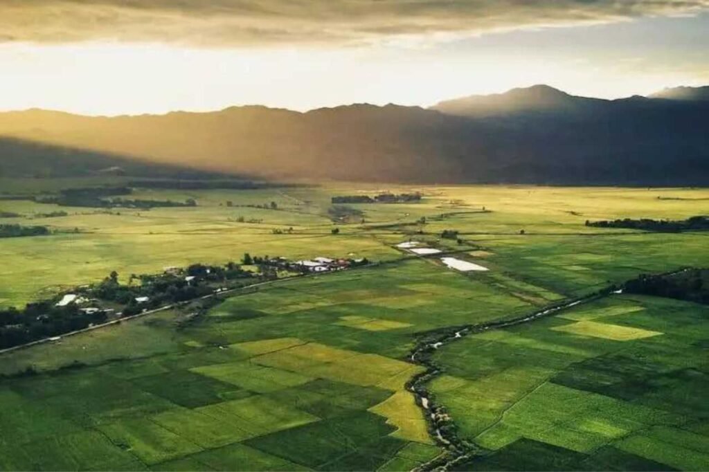
Thoubal, located in the Thoubal district of the Indian state of Manipur, serves as both a town and a municipal council comprising 18 wards. As the district’s headquarters, it derives its name from ‘Athouba,’ signifying brave and courageous individuals, a reflection of its local population. Among the larger towns in Manipur, Thoubal boasts a serene environment with abundant lakes, rivers, lush paddy fields, and gardens. Additionally, it holds strategic significance as the Trans-Asian highway (AH1) traverses through, acting as a gateway to South-East Asia. Thoubal enjoys excellent connectivity to neighboring areas such as Imphal, Kakching, Moreh, and Yairipok.
History
In May 1983, the establishment of this district marked its inception when the Thoubal sub-division, previously part of the former Manipur Central District (later known as Imphal district), was reallocated to form a distinct administrative region. Subsequently, in November 1983, Thoubal district underwent a division into two separate sub-divisions, namely Thoubal and Kakching, encompassing Kakching and Waikhong Tahsils. Currently, Thoubal district consists of three sub-divisions: Thoubal, Lilong, and Kakching, each contributing to the administrative and territorial makeup of the district.
Demography
As per the 2011 census, Thoubal district in India had a population of 422,168, akin to the nation of Malta, ranking 555th out of 640 districts. The district boasted a population density of 818 individuals per square kilometer (2,120/sq mi) and experienced a 15.48% population growth from 2001 to 2011. Thoubal exhibited a sex ratio of 1006 females per 1000 males, with a literacy rate of 76.66%. Following the separation of Kakching district, the remaining Thoubal district had a population of 286,687, with a sex ratio of 1002 females per 1000 males. Approximately 35.82% of the population resided in urban areas, and Manipuri was the predominant language, spoken by 99.35% of the populace. Scheduled Castes and Scheduled Tribes constituted 0.43% and 0.23% of the population, respectively.
Geography
The district encompasses the majority of the eastern portion of the Manipur Valley, forming an irregular triangular shape oriented with its base to the north. Its geographic coordinates range between 23° 45′ – 24° 45′ North latitudes and 93° 45′ – 94° 15′ East longitudes, placing it in the hilly terrain of northeastern India. The district’s average elevation stands at approximately 790 meters above sea level, characterized by a landscape adorned with a scattering of low-lying hillocks and hills. Among these natural features, Punam Hill stands out, boasting an elevation of 1009 meters above sea level, contributing to the district’s unique topography.