Pincodes of Ujjain
Ujjain district, located in the Indian state of Madhya Pradesh, is known for its cultural and historical significance. It is home to the holy city of Ujjain, a prominent pilgrimage destination for Hindus. Ujjain district encompasses a rich heritage, including temples, ghats, and festivals. The district is identified by various pincodes. Ujjain pincodes help in postal services and location identification.
Here is a list of Ujjain Pincodes
| No. | Location | Pincode | District | State |
|---|---|---|---|---|
| 1 | Aajdawada | 456776 | Ujjain | Madhya Pradesh |
| 2 | Aajmabad | 456441 | Ujjain | Madhya Pradesh |
| 3 | Akasoda | 456222 | Ujjain | Madhya Pradesh |
| 4 | Akya jagir | 456224 | Ujjain | Madhya Pradesh |
| 5 | Alot Jagir | 456221 | Ujjain | Madhya Pradesh |
| 6 | Amla | 456771 | Ujjain | Madhya Pradesh |
| 7 | Amodiya | 456006 | Ujjain | Madhya Pradesh |
| 8 | Asawata | 456771 | Ujjain | Madhya Pradesh |
| 9 | Aslavada | 456337 | Ujjain | Madhya Pradesh |
| 10 | Badagaon | 456776 | Ujjain | Madhya Pradesh |
| 11 | Badkummed | 456661 | Ujjain | Madhya Pradesh |
| 12 | Baghera | 456770 | Ujjain | Madhya Pradesh |
| 13 | Baledi | 456222 | Ujjain | Madhya Pradesh |
| 14 | Baloda Lakkha | 456776 | Ujjain | Madhya Pradesh |
| 15 | Bamnapati | 456222 | Ujjain | Madhya Pradesh |
| 16 | Banbana | 456335 | Ujjain | Madhya Pradesh |
| 17 | Bangred | 456771 | Ujjain | Madhya Pradesh |
| 18 | Bappiya | 456440 | Ujjain | Madhya Pradesh |
| 19 | Barkheda buzurg | 456443 | Ujjain | Madhya Pradesh |
| 20 | Barkheda pitramal | 456335 | Ujjain | Madhya Pradesh |
| 21 | Barkheda Madan | 456221 | Ujjain | Madhya Pradesh |
| 22 | Barnagar | 456771 | Ujjain | Madhya Pradesh |
| 23 | Barnagar bunglow | 456771 | Ujjain | Madhya Pradesh |
| 24 | Barnagar Town | 456771 | Ujjain | Madhya Pradesh |
| 25 | Batlawdi | 456224 | Ujjain | Madhya Pradesh |
| 26 | Bedavan | 456221 | Ujjain | Madhya Pradesh |
| 27 | Berchha | 456440 | Ujjain | Madhya Pradesh |
| 28 | Bhainsoda | 456224 | Ujjain | Madhya Pradesh |
| 29 | Bhatisuda | 456331 | Ujjain | Madhya Pradesh |
| 30 | Bhatkhedi | 456224 | Ujjain | Madhya Pradesh |
| 31 | Bhatpachlana | 456313 | Ujjain | Madhya Pradesh |
| 32 | Bhikampur | 456313 | Ujjain | Madhya Pradesh |
| 33 | Bichrod | 456665 | Ujjain | Madhya Pradesh |
| 34 | Birakhedi | 456771 | Ujjain | Madhya Pradesh |
| 35 | Birlagram nagda | 456331 | Ujjain | Madhya Pradesh |
| 36 | Bolasa | 456664 | Ujjain | Madhya Pradesh |
| 37 | Buranabad | 456224 | Ujjain | Madhya Pradesh |
| 38 | Chadawad | 456665 | Ujjain | Madhya Pradesh |
| 39 | Chandesara | 456664 | Ujjain | Madhya Pradesh |
| 40 | Chapakhedi | 456224 | Ujjain | Madhya Pradesh |
| 41 | Chapaner | 456224 | Ujjain | Madhya Pradesh |
| 42 | Chikli | 456222 | Ujjain | Madhya Pradesh |
| 43 | Chintaman Jawasia | 456006 | Ujjain | Madhya Pradesh |
| 44 | Chirola | 456313 | Ujjain | Madhya Pradesh |
| 45 | Chirola chhota | 456313 | Ujjain | Madhya Pradesh |
| 46 | Chitavad | 456443 | Ujjain | Madhya Pradesh |
| 47 | Dangwada | 456222 | Ujjain | Madhya Pradesh |
| 48 | Delchi buzurg | 456440 | Ujjain | Madhya Pradesh |
| 49 | Dhabla hardu | 456550 | Ujjain | Madhya Pradesh |
| 50 | Dharakheda | 456443 | Ujjain | Madhya Pradesh |
| 51 | Dungarkheda | 456550 | Ujjain | Madhya Pradesh |
| 52 | Durgapura | 456331 | Ujjain | Madhya Pradesh |
| 53 | Etawa | 456668 | Ujjain | Madhya Pradesh |
| 54 | Ghattia | 456550 | Ujjain | Madhya Pradesh |
| 55 | Ghinoda | 456224 | Ujjain | Madhya Pradesh |
| 56 | Ghonsla | 456550 | Ujjain | Madhya Pradesh |
| 57 | Ghudawan | 456222 | Ujjain | Madhya Pradesh |
| 58 | Gogakheda | 456441 | Ujjain | Madhya Pradesh |
| 59 | Goyalabujurg | 456006 | Ujjain | Madhya Pradesh |
| 60 | Harnawada | 456222 | Ujjain | Madhya Pradesh |
| 61 | Harsodhan | 456661 | Ujjain | Madhya Pradesh |
| 62 | Hatai | 456335 | Ujjain | Madhya Pradesh |
| 63 | Indokh | 456441 | Ujjain | Madhya Pradesh |
| 64 | Ingoria | 456222 | Ujjain | Madhya Pradesh |
| 65 | Jagoti | 456550 | Ujjain | Madhya Pradesh |
| 66 | Jahagirpur | 456337 | Ujjain | Madhya Pradesh |
| 67 | Jalodia | 456771 | Ujjain | Madhya Pradesh |
| 68 | Jalwa | 456550 | Ujjain | Madhya Pradesh |
| 69 | Jawasia Kumar | 456770 | Ujjain | Madhya Pradesh |
| 70 | Jethal | 456006 | Ujjain | Madhya Pradesh |
| 71 | Jharda | 456441 | Ujjain | Madhya Pradesh |
| 72 | Jhitarkhedi | 456550 | Ujjain | Madhya Pradesh |
| 73 | Jhutawad | 456440 | Ujjain | Madhya Pradesh |
| 74 | Kachnariya | 456664 | Ujjain | Madhya Pradesh |
| 75 | Kachria | 456441 | Ujjain | Madhya Pradesh |
| 76 | Kadoudiya | 456668 | Ujjain | Madhya Pradesh |
| 77 | Kagdikaradia | 456006 | Ujjain | Madhya Pradesh |
| 78 | Kaliadeh | 456006 | Ujjain | Madhya Pradesh |
| 79 | Kaluheda | 456006 | Ujjain | Madhya Pradesh |
| 80 | Kamthana | 456313 | Ujjain | Madhya Pradesh |
| 81 | Kanardi | 456770 | Ujjain | Madhya Pradesh |
| 82 | Kanasia | 456770 | Ujjain | Madhya Pradesh |
| 83 | Kanwas | 456224 | Ujjain | Madhya Pradesh |
| 84 | Kapeli | 456668 | Ujjain | Madhya Pradesh |
| 85 | Karedimataji | 456770 | Ujjain | Madhya Pradesh |
| 86 | Karohan | 456006 | Ujjain | Madhya Pradesh |
| 87 | Kathbarode | 456770 | Ujjain | Madhya Pradesh |
| 88 | Kaytha | 456665 | Ujjain | Madhya Pradesh |
| 89 | Kesaria | 456224 | Ujjain | Madhya Pradesh |
| 90 | Keson | 456550 | Ujjain | Madhya Pradesh |
| 91 | Khachraud | 456224 | Ujjain | Madhya Pradesh |
| 92 | Khachraud Rs | 456224 | Ujjain | Madhya Pradesh |
| 93 | Khajuria | 456770 | Ujjain | Madhya Pradesh |
| 94 | Khandoda | 456222 | Ujjain | Madhya Pradesh |
| 95 | Kharsod Khurd | 456222 | Ujjain | Madhya Pradesh |
| 96 | Kharsodkalan | 456313 | Ujjain | Madhya Pradesh |
| 97 | Khedakhajuria | 456443 | Ujjain | Madhya Pradesh |
| 98 | Khedavada | 456776 | Ujjain | Madhya Pradesh |
| 99 | Kundikheda | 456441 | Ujjain | Madhya Pradesh |
| 100 | Lalgarh | 456441 | Ujjain | Madhya Pradesh |
| 101 | Lekoda | 456006 | Ujjain | Madhya Pradesh |
| 102 | Lekoda Anjana | 456337 | Ujjain | Madhya Pradesh |
| 103 | Lohana | 456771 | Ujjain | Madhya Pradesh |
| 104 | Lotiyajunarda | 456441 | Ujjain | Madhya Pradesh |
| 105 | Madawda | 456313 | Ujjain | Madhya Pradesh |
| 106 | Mahu | 456443 | Ujjain | Madhya Pradesh |
| 107 | Mahudi | 456550 | Ujjain | Madhya Pradesh |
| 108 | Makdavan | 456337 | Ujjain | Madhya Pradesh |
| 109 | Makdone | 456668 | Ujjain | Madhya Pradesh |
| 110 | Makla | 456441 | Ujjain | Madhya Pradesh |
| 111 | Malikhedi | 456550 | Ujjain | Madhya Pradesh |
| 112 | Matana kalan | 456664 | Ujjain | Madhya Pradesh |
| 113 | Mehatvas | 456331 | Ujjain | Madhya Pradesh |
| 114 | Mehidpur | 456443 | Ujjain | Madhya Pradesh |
| 115 | Mehidpur bazar | 456443 | Ujjain | Madhya Pradesh |
| 116 | Mehidpur road | 456440 | Ujjain | Madhya Pradesh |
| 117 | Molana | 456771 | Ujjain | Madhya Pradesh |
| 118 | Nagda | 456335 | Ujjain | Madhya Pradesh |
| 119 | Nagda town | 456335 | Ujjain | Madhya Pradesh |
| 120 | Nainawad | 456770 | Ujjain | Madhya Pradesh |
| 121 | Nalva | 456222 | Ujjain | Madhya Pradesh |
| 122 | Nanded | 456668 | Ujjain | Madhya Pradesh |
| 123 | Nandiyasi | 456313 | Ujjain | Madhya Pradesh |
| 124 | Narsingarh | 456313 | Ujjain | Madhya Pradesh |
| 125 | Narwar | 456664 | Ujjain | Madhya Pradesh |
| 126 | Nauganwa | 456664 | Ujjain | Madhya Pradesh |
| 127 | Navakheda | 456006 | Ujjain | Madhya Pradesh |
| 128 | Nayapura | 456006 | Ujjain | Madhya Pradesh |
| 129 | Nazarpur | 456550 | Ujjain | Madhya Pradesh |
| 130 | Nimboda | 456222 | Ujjain | Madhya Pradesh |
| 131 | Nogaova | 456665 | Ujjain | Madhya Pradesh |
| 132 | Pachlasi | 456224 | Ujjain | Madhya Pradesh |
| 133 | Palduna | 456771 | Ujjain | Madhya Pradesh |
| 134 | Palsoda Makdavan | 456337 | Ujjain | Madhya Pradesh |
| 135 | Panbihar | 456006 | Ujjain | Madhya Pradesh |
| 136 | Panthpiplai | 456006 | Ujjain | Madhya Pradesh |
| 137 | Parsoli | 456550 | Ujjain | Madhya Pradesh |
| 138 | Paslod | 456221 | Ujjain | Madhya Pradesh |
| 139 | Pat | 456550 | Ujjain | Madhya Pradesh |
| 140 | Peerjhalar | 456771 | Ujjain | Madhya Pradesh |
| 141 | Pipliahama | 456006 | Ujjain | Madhya Pradesh |
| 142 | Piploda baghla | 456337 | Ujjain | Madhya Pradesh |
| 143 | Piploda dwarkadhish | 456664 | Ujjain | Madhya Pradesh |
| 144 | Piplu | 456771 | Ujjain | Madhya Pradesh |
| 145 | Ratadia | 456006 | Ujjain | Madhya Pradesh |
| 146 | Rnayarapeer | 456441 | Ujjain | Madhya Pradesh |
| 147 | Rohil khurd | 456335 | Ujjain | Madhya Pradesh |
| 148 | Roopakhedi | 456668 | Ujjain | Madhya Pradesh |
| 149 | Rui | 456006 | Ujjain | Madhya Pradesh |
| 150 | Run Kheda | 456224 | Ujjain | Madhya Pradesh |
| 151 | Runija | 456776 | Ujjain | Madhya Pradesh |
| 152 | Rupeta | 456335 | Ujjain | Madhya Pradesh |
| 153 | Sagwali | 456440 | Ujjain | Madhya Pradesh |
| 154 | Samgi | 456770 | Ujjain | Madhya Pradesh |
| 155 | Sandla | 456337 | Ujjain | Madhya Pradesh |
| 156 | Semliya | 456443 | Ujjain | Madhya Pradesh |
| 157 | Shakkar khedi | 456443 | Ujjain | Madhya Pradesh |
| 158 | Shrivatsa | 456224 | Ujjain | Madhya Pradesh |
| 159 | Sijavta | 456222 | Ujjain | Madhya Pradesh |
| 160 | Sodang | 456006 | Ujjain | Madhya Pradesh |
| 161 | Sumrakheda | 456665 | Ujjain | Madhya Pradesh |
| 162 | Sundarabad | 456776 | Ujjain | Madhya Pradesh |
| 163 | Suwasa | 456337 | Ujjain | Madhya Pradesh |
| 164 | Tajpur | 456661 | Ujjain | Madhya Pradesh |
| 165 | Takwasa | 456006 | Ujjain | Madhya Pradesh |
| 166 | Talod | 456006 | Ujjain | Madhya Pradesh |
| 167 | Tarana | 456665 | Ujjain | Madhya Pradesh |
| 168 | Tarana town | 456665 | Ujjain | Madhya Pradesh |
| 169 | Tilawad | 456668 | Ujjain | Madhya Pradesh |
| 170 | Tulaheda | 456550 | Ujjain | Madhya Pradesh |
| 171 | Tutiya khedi | 456440 | Ujjain | Madhya Pradesh |
| 172 | Ujjain | 456001 | Ujjain | Madhya Pradesh |
| 173 | Ujjain bherugarh | 456003 | Ujjain | Madhya Pradesh |
| 174 | Ujjain chhota sarafa | 456006 | Ujjain | Madhya Pradesh |
| 175 | Ujjain city | 456006 | Ujjain | Madhya Pradesh |
| 176 | Ujjain danigate | 456006 | Ujjain | Madhya Pradesh |
| 177 | Ujjain desai nagar | 456010 | Ujjain | Madhya Pradesh |
| 178 | Ujjain factory | 456001 | Ujjain | Madhya Pradesh |
| 179 | Ujjain govt. engg. college | 456010 | Ujjain | Madhya Pradesh |
| 180 | Ujjain gujrati samaj | 456006 | Ujjain | Madhya Pradesh |
| 181 | Ujjain kothi | 456010 | Ujjain | Madhya Pradesh |
| 182 | Ujjain m.l.nagar | 456010 | Ujjain | Madhya Pradesh |
| 183 | Ujjain madhonagar | 456010 | Ujjain | Madhya Pradesh |
| 184 | Ujjain pandariba | 456006 | Ujjain | Madhya Pradesh |
| 185 | Ujjain qumri marg | 456006 | Ujjain | Madhya Pradesh |
| 186 | Ujjain rishi nagar | 456010 | Ujjain | Madhya Pradesh |
| 187 | Ujjain shri mahakal | 456006 | Ujjain | Madhya Pradesh |
| 188 | Ujjain sindhi colony | 456010 | Ujjain | Madhya Pradesh |
| 189 | Ujjain Daulatganj | 456001 | Ujjain | Madhya Pradesh |
| 190 | Ujjain Vikram university | 456010 | Ujjain | Madhya Pradesh |
| 191 | Ujjainiya | 456550 | Ujjain | Madhya Pradesh |
| 192 | Undasa | 456006 | Ujjain | Madhya Pradesh |
| 193 | Unhel | 456221 | Ujjain | Madhya Pradesh |
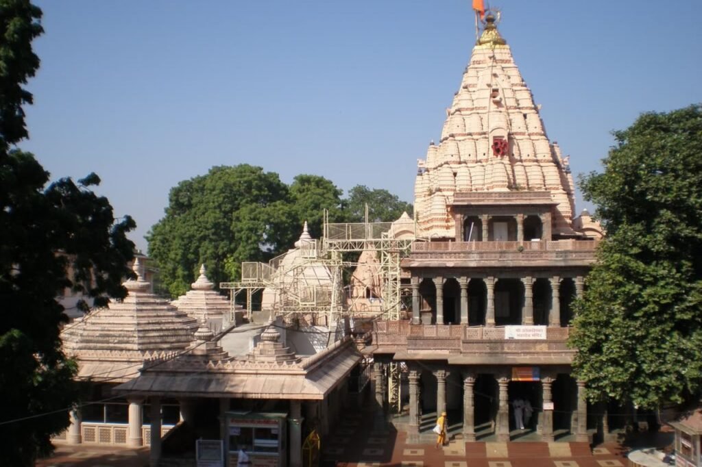
About Ujjain
Ujjain district, situated in central India, is a part of Madhya Pradesh. The district is known for its historic city, Ujjain, which serves as the district headquarters. Covering an area of 6,091 square kilometers, it had a population of 19,86,864 as per the 2011 census, marking a 16.12% growth from its 2001 population of 17,10,982.
History:
Ujjain district in Madhya Pradesh has a rich history dating back centuries. It’s most famous for its association with ancient Indian culture, spirituality, and learning. Ujjain, the district’s center, has been a hub of religious and scholarly activities.
In ancient times, it was known as Avanti and was a significant center for trade and culture. It’s mentioned in Hindu scriptures and was a prominent place for pilgrimage.
During the Mauryan and Gupta empires, Ujjain flourished as a center of learning and astronomy. It’s also known for the Kumbh Mela, a massive religious gathering held every 12 years.
In more recent history, Ujjain was under the rule of various dynasties and empires, including the Marathas and the British. Today, it stands as a blend of its rich past and modern development.
Geography:
Ujjain district is situated in the heart of India, in the state of Madhya Pradesh. It covers an area of approximately 6,091 square kilometers. The district’s geography is characterized by its relatively flat terrain with the Malwa Plateau gently sloping towards the south.
Forests are limited in this district, and the landscape mainly consists of agricultural fields, urban areas, and small hills. The district is intersected by the Kshipra River, which is considered holy and plays a significant role in the religious life of the region. The river flows through Ujjain city and is known for the grand Kumbh Mela held on its banks.
Ujjain district is part of the Malwa region and is known for its fertile agricultural land. The climate is generally hot and dry in the summer, with a monsoon season bringing rainfall from June to September. This district’s geography reflects its historical and cultural importance, especially as a center of Hindu pilgrimage and tradition.
Demographics:
In 2011, Ujjain District had a total population of 1,986,864 people, making it the 233rd most populous district in India. The district is relatively dense, with 326 people living in every square kilometer of land. In terms of gender, there were 954 females for every 1000 males.
The literacy rate in Ujjain was 73.55%, indicating that a significant portion of the population can read and write. About 39.22% of the people lived in urban areas, while the rest resided in rural regions.
Regarding languages spoken, Malvi was the most commonly used language, spoken by 47.58% of the population. Hindi was also widely spoken, with 47.30% of the people using it as their primary language. Other languages like Urdu, Gujarati, Marathi, and Sindhi were spoken by smaller percentages of the population.
Administration:
Following the 2008 delimitation of parliamentary and legislative assembly constituencies, Ujjain district is now divided into eight Vidhan Sabha constituencies: Nagada-Khachrod, Mahidpur, Tarana, Ghatiya, Ujjain Dakshin, Ujjain Uttar, and Badnagar, with some parts coming from Ratlam District. It has been reserved for candidates belonging to the Scheduled Castes since 1966.