Pincode of Mangalagiri
The historic town of Mangalagiri in Andhra Pradesh, India, is denoted by the pincode 522503. Mangalagiri, well-known for its historic temples, cultural significance, and expansive vistas, presents an alluring fusion of heritage and unspoiled beauty. Discover tranquil lakes, verdant hills, and centuries-old shrines that showcase the town’s breathtaking scenery and rich history. Access to the center of this cultural treasure, where spirituality, tradition, and breathtaking scenery coexist peacefully, is made possible by the Mangalagiri Pincode 522503. These pincodes provide an enriching excursion into Mangalagiri’s cultural and scenic attractiveness, whether you choose to climb the famous hilltop temple, immerse yourself in native traditions, or simply enjoy the expansive vistas.
Here is a list of Mangalagiri Pincode
| No. | Location | Pincode | District | State |
|---|---|---|---|---|
| 1 | Mangalagiri | 522503 | Guntur | Andhra Pradesh |
About Mangalagiri
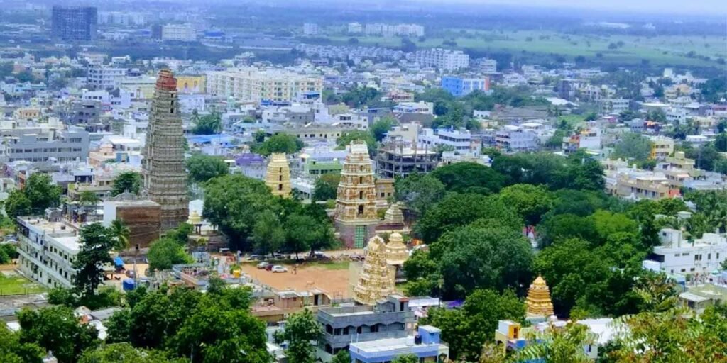
Mangalagiri is a significant Vijayawada suburb located in the Guntur district of the Andhra Pradesh state in India. The town is a component of both the Tenali revenue division and the Mangalagiri Tadepalli Municipal Corporation. It is a portion of the Capital Region of Andhra Pradesh. It is located between Vijayawada and Guntur on National Highway 16. Mangalagiri Tadepalli Municipal Corporation is the result of the merger of ten villages: Chinakakani, Kaza, Nutakki, Chinavadlapudi, Pedavadlapudi, Ramachandrapuram, Atamakuru, Nowluru, Yerrabalem, Nidamarru, and Bethapudi. The court case pertaining to the village merger is now pending.
History
It is dated 1520 and tells of Kondavidu’s capture in 1515 from the Gajapati lords of Kalinga (old Odisha) by Timmarusu, the general of Sri Krishnadevaraya. Inscriptions on four sides of a different stone next to the Garudalvar temple chronicle grants made in 1538 under the reign of Sadasiva Raya of the Vijayanagara Empire. The majestic gopuram of the temple at the base of the hill was built between 1807 and 1809 by Raja Vasireddy Venkatadri Nayudu. This temple is a prime example of ancient Vishwakarma sthapathis’ architectural and artistic techniques.
Geography
The coordinates of Mangalagiri are 16.43°N 80.55°E. Its average elevation is 95.4 feet, or 29.08 meters.By road, it is situated 30 km (19 km) to the north west of Tenali, 15 km (9.3 mi) south west of Vijayawada, and 22 km (14 mi) northeast of the district capital, Guntur. It is situated in a steep area. Under Seismic Zone 3, it is located.
Climate
Mangalagiri has a tropical climate. March through May are the hottest months, and December through January are the coolest. It experiences north-east monsoons in mid-December and south-west monsoons from July to October. 50–60 cm (20–24 in) of rain falls on average each year. There is a range of 44–46 °C (111–115 °F) in the summer and 22–23 °C (72–73 °F) in the winter.
Demography
19,137 homes and 73,613 people lived in the town as per the 2011 Indian Census. The overall population is made up of 37,081 females and 36,532 men, or 1015 females for every 1000 males. 7,706 children, or 979 per 1000, are in the 0–6 age range. Of them, 3,894 are males and 3,812 are girls. Out of 50,197 literates, the average literacy rate is 76.16%, which is substantially higher than the state average of 67.41%.
Tourism
Situated in Mangalagiri, the Lakshmi Narasimha Temple is the dwelling place of Lord Vishnu, who took on the form of Thotadri. The Narasimha Swamy temples are three in number. One example of Indian rock-cut architecture is the Undavalli caves, which are situated in Undavalli. Built in the 4th and 5th centuries, the historic caverns are perched on hillsides with sweeping views of the Krishna River.
King Vishnukundina is connected to the Undavalli Cave Temples, which are devoted to Ananta Padmanabha Swamy and Narasimha Swamy. Located in Namburu, the Hinkar Thirtha Jain Temple is the most expansive Jain temple in the area, drawing numerous Jains from all regions of the state.