Pincodes of Warangal
The Warangal Pincodes include an extensive range of areas, ranging from the bustling 506369 to the historic 506002 located in the central region of Telangana, India. These codes grant access to Warangal’s educational institutions, historical significance, and rich cultural legacy. Discover famous sites like the Warangal Fort, savor the local cuisine, and take in the vivid arts and crafts of the city. Warangal Pincodes provide access to the heart of this area, where modernism and history coexist together. These pincodes offer a fascinating trip into the center of Warangal, making it an alluring location for locals and visitors alike, whether you’re looking to explore historic temples or pursue educational possibilities.
Here is a list of Warangal Pincodes
| No. | Location | Pincode | District | State |
|---|---|---|---|---|
| 1 | Aanole | 506310 | Warangal | Telangana |
| 2 | Abadighanpur | 506144 | Warangal | Telangana |
| 3 | Abbaipalem | 506315 | Warangal | Telangana |
| 4 | Abbapur | 506343 | Warangal | Telangana |
| 5 | Abdulnagaram | 506145 | Warangal | Telangana |
| 6 | Adavikamalapur | 506169 | Warangal | Telangana |
| 7 | Agapet | 506324 | Warangal | Telangana |
| 8 | Agricultur Research station | 506007 | Warangal | Telangana |
| 9 | Ainapur | 506355 | Warangal | Telangana |
| 10 | Akinepalli | 506366 | Warangal | Telangana |
About Warangal
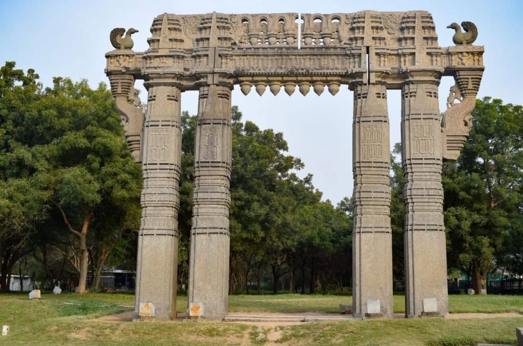
The district headquarters of Warangal district is located in Warangal, a city in the Indian state of Telangana. With 704,570 residents according to the 2011 Indian Census and a total area of 406 square kilometer, it is the second-biggest city in Telangana. The Kakatiya dynasty, which was founded in 1163, had Warangal as its capital. The Kakatiyas left behind landmarks such as lakes, temples, fortifications, and stone gates that have contributed to the city’s current status as a well-liked tourist destination. Warangal is sometimes referred to as Telangana’s cultural capital, and the state administration placed the Kakatiya Kala Thoranam in the state’s logo.
History
The Kakatiya dynasty’s former capital was Warangal. Numerous monarchs, including Rudradeva, Mahadeva, Ganapathideva, Prataparudra, Beta Raja I, Prola Raja I, Beta Raja II, Prola Raja III, and Rani Rudrama Devi, the only female ruler of the Telugu region, ruled over it.
The Kakatiya Dynasty was founded by Beta Raja I, who ruled the kingdom for thirty years before his son Prola Raja I took over and moved the capital to Hanamkonda. Warangal replaced Hanamkonda as the capital city during Ganapathideva’s reign. Warangal was hailed in Kakatiya Period inscriptions as the best city in the Telugu region up to the ocean’s edge.
Geography
The coordinates of Warangal are 18.0°N 79.58°E. It is 266 meters above sea level on average. Situated in the eastern sector of the Deccan Plateau, the area is characterized by granite rocks and hill formations, leaving it desolate and reliant on seasonal rains for farming. Since there are no significant rivers in the area, the city depends on the Kakatiya Canal, which rises from the Sriram Sagar Project, to supply its water needs.
Warangal, which is in Telangana’s semi-arid region, experiences mostly hot, dry weather. March marks the beginning of summer, which peaks in May with average highs in the region of 42 °C. The monsoon, which brings with it roughly 550 mm of precipitation, begins in June and lasts until September.
Demography
The population of the city was 627,449 as per the 2011 Indian Census, and it has since grown to 830,281. With 83% of the population practicing Hinduism, it is the predominant religion in Warangal. At 14%, Islam is the largest minority. There are tiny Buddhist, Jewish, and Christian groups.
Economy
Along with other Indian towns like Gandhinagar and Kozhikode, Warangal has experienced a sharp increase in urbanization from 19% to 28% as per the 2011 census. The primary economic activity is agriculture, which depends primarily on seasonal rainfall and the monsoon. The main crops are wheat, cotton, mangoes, and paddy. The Godavari lift irrigation system, which is intended to raise water from the Godavari river to irrigate drought-prone Telangana districts, helps Warangal.
Culture
The term “Warangalites” is frequently used to describe the city’s citizens. The Ramappa Temple, the Thousand Pillar Temple, and the Warangal Fort are all included on the UNESCO list of World Heritage Sites. The other noteworthy locations of different religions are Bhadrakali Temple, Padmakshi Temple, Mettu Gutta, Govinda Rajula Gutta, Roman Catholic Diocese of Warangal, Kazipet Dargah, Ursu Gutta, and Erragattu Gutta.
The lakes that are famous for tourism are Dharmasagar Lake, Waddepally Lake, and Bhadrakali Lake. The country’s first and largest Geo-Bio-Diversity cultural park, featuring promenades, historic caves, suspension bridges, natural pathways, nesting grounds, and ecological reserves, is being created around Bhadrakali Temple Lake.